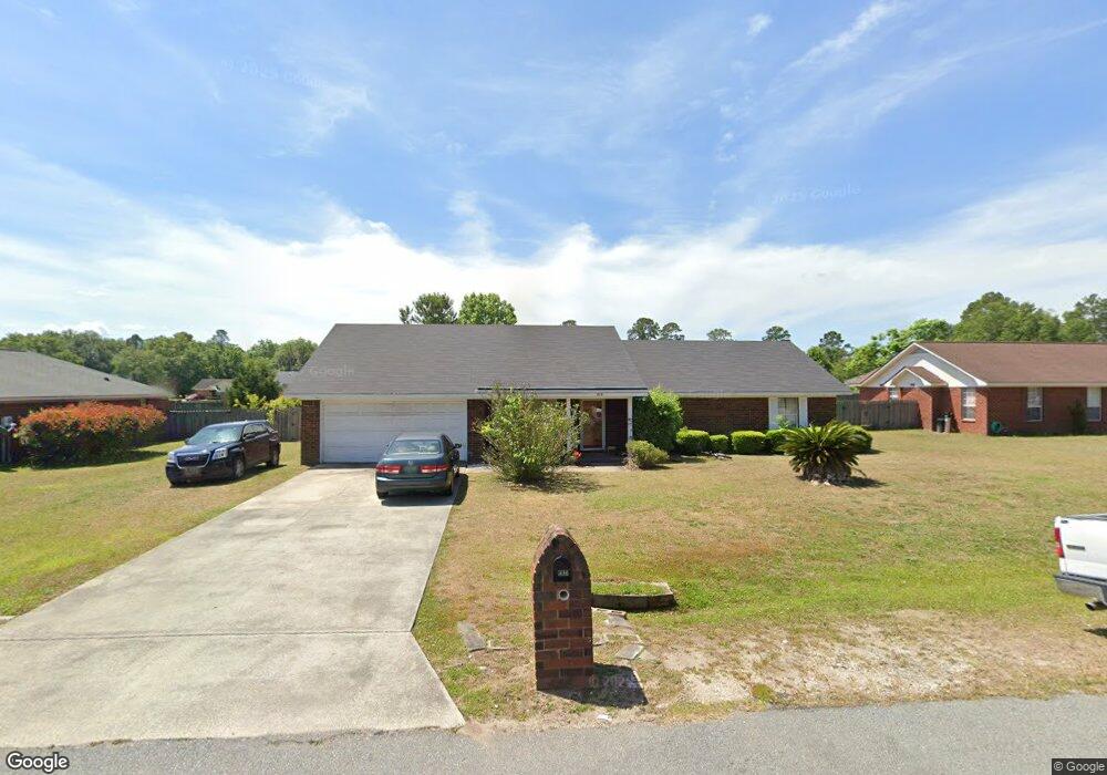
215 Stephanie Dr Allenhurst, GA 31301
Estimated Value: $237,000 - $251,000
3
Beds
2
Baths
1,663
Sq Ft
$146/Sq Ft
Est. Value
About This Home
This home is located at 215 Stephanie Dr, Allenhurst, GA 31301 and is currently estimated at $242,326, approximately $145 per square foot. 215 Stephanie Dr is a home located in Liberty County with nearby schools including Frank Long Elementary School, Lewis Frasier Middle School, and Liberty County High School.
Ownership History
Date
Name
Owned For
Owner Type
Purchase Details
Closed on
Feb 3, 2020
Sold by
Barnes Rodney N
Bought by
Barnes Deborah
Current Estimated Value
Purchase Details
Closed on
Dec 14, 2007
Sold by
Barnes Rodney N
Bought by
Barnes Deborah
Home Financials for this Owner
Home Financials are based on the most recent Mortgage that was taken out on this home.
Original Mortgage
$148,117
Interest Rate
6.21%
Mortgage Type
VA
Purchase Details
Closed on
Dec 30, 1999
Sold by
Roc Enterprises
Bought by
Chapman Barry S
Purchase Details
Closed on
Mar 15, 1996
Bought by
Roc Enterprises
Create a Home Valuation Report for This Property
The Home Valuation Report is an in-depth analysis detailing your home's value as well as a comparison with similar homes in the area
Home Values in the Area
Average Home Value in this Area
Purchase History
| Date | Buyer | Sale Price | Title Company |
|---|---|---|---|
| Barnes Deborah | -- | -- | |
| Barnes Deborah | -- | -- | |
| Barnes Rodney N | $145,000 | -- | |
| Chapman Barry S | $81,900 | -- | |
| Roc Enterprises | $13,000 | -- |
Source: Public Records
Mortgage History
| Date | Status | Borrower | Loan Amount |
|---|---|---|---|
| Previous Owner | Barnes Rodney N | $148,117 |
Source: Public Records
Tax History Compared to Growth
Tax History
| Year | Tax Paid | Tax Assessment Tax Assessment Total Assessment is a certain percentage of the fair market value that is determined by local assessors to be the total taxable value of land and additions on the property. | Land | Improvement |
|---|---|---|---|---|
| 2024 | $2,612 | $74,174 | $14,000 | $60,174 |
| 2023 | $2,612 | $68,434 | $10,000 | $58,434 |
| 2022 | $2,012 | $56,878 | $10,000 | $46,878 |
| 2021 | $1,828 | $52,267 | $10,000 | $42,267 |
| 2020 | $1,705 | $48,916 | $10,000 | $38,916 |
| 2019 | $1,680 | $49,405 | $10,000 | $39,405 |
| 2018 | $1,678 | $49,894 | $10,000 | $39,894 |
| 2017 | $2,138 | $50,383 | $10,000 | $40,383 |
| 2016 | $1,596 | $50,871 | $10,000 | $40,871 |
| 2015 | $1,689 | $48,830 | $10,000 | $38,830 |
| 2014 | $1,689 | $53,060 | $10,000 | $43,060 |
| 2013 | -- | $50,603 | $10,000 | $40,603 |
Source: Public Records
Map
Nearby Homes
- 166 Stephanie Dr
- 480 Mccumber Dr
- 619 Mccumber Dr
- 100 Mccumber Dr
- 996 Dunlevie Rd
- 89 Salette St
- 0 & 1 Denise Ln
- 7.22 AC Dunlevie Rd
- 0 W Oglethorpe Hwy
- 534 Deer Meadow Way
- 685 Deer Meadow Way
- 256 Deer Meadow Way
- 1118 Buckhead Loop
- 684 Deer Meadow Way
- 514 Deer Meadow Way
- 554 Deer Meadow Way
- 704 Deer Meadow Way
- 575 Deer Meadow Way
- 593 Deer Meadow Way
- 662 Deer Meadow Way
- 235 Stephanie Dr
- 439 Mccumber Dr
- 459 Mccumber Dr
- 419 Mccumber Dr
- 175 Stephanie Dr
- 226 Stephanie Dr
- 206 Stephanie Dr
- 165 Stephanie Dr
- 479 Mccumber Dr
- 246 Stephanie Dr
- 186 Stephanie Dr
- 155 Stephanie Dr
- 273 Stephanie Dr
- 266 Stephanie Dr
- 499 Mccumber Dr Unit LOT 97
- 19 Annette Ln
- 460 Mccumber Dr
- 420 Mccumber Dr
- 151 Tempest Ln
- 169 Tempest Ln