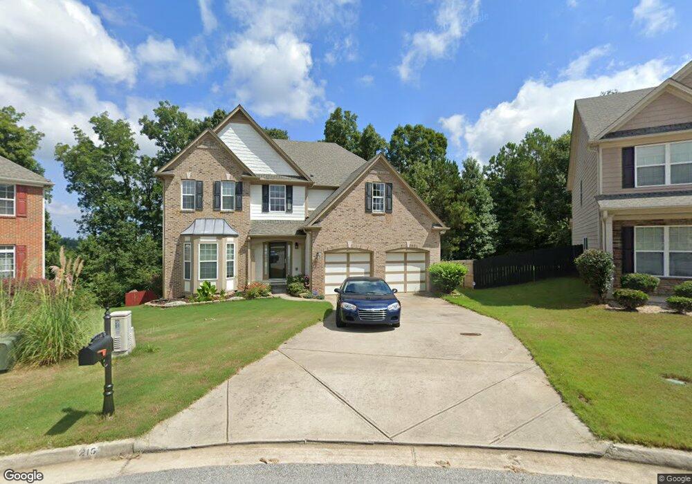
215 Tralee Cir Fairburn, GA 30213
Estimated Value: $398,870 - $469,000
4
Beds
3
Baths
3,218
Sq Ft
$133/Sq Ft
Est. Value
About This Home
This home is located at 215 Tralee Cir, Fairburn, GA 30213 and is currently estimated at $429,468, approximately $133 per square foot. 215 Tralee Cir is a home located in Fulton County with nearby schools including Renaissance Middle School, Langston Hughes High School, and Landmark Christian School.
Ownership History
Date
Name
Owned For
Owner Type
Purchase Details
Closed on
Dec 21, 2011
Sold by
French Amber Maria
Bought by
Barnes Rodney B
Current Estimated Value
Home Financials for this Owner
Home Financials are based on the most recent Mortgage that was taken out on this home.
Original Mortgage
$163,000
Outstanding Balance
$111,824
Interest Rate
4.07%
Mortgage Type
VA
Estimated Equity
$317,644
Purchase Details
Closed on
Nov 16, 2007
Sold by
Arlington Builders Llc
Bought by
French Jason and French Amber
Home Financials for this Owner
Home Financials are based on the most recent Mortgage that was taken out on this home.
Original Mortgage
$262,480
Interest Rate
6.32%
Mortgage Type
New Conventional
Create a Home Valuation Report for This Property
The Home Valuation Report is an in-depth analysis detailing your home's value as well as a comparison with similar homes in the area
Home Values in the Area
Average Home Value in this Area
Purchase History
| Date | Buyer | Sale Price | Title Company |
|---|---|---|---|
| Barnes Rodney B | $163,000 | -- | |
| French Jason | $262,500 | -- |
Source: Public Records
Mortgage History
| Date | Status | Borrower | Loan Amount |
|---|---|---|---|
| Open | Barnes Rodney B | $163,000 | |
| Previous Owner | French Jason | $262,480 |
Source: Public Records
Tax History Compared to Growth
Tax History
| Year | Tax Paid | Tax Assessment Tax Assessment Total Assessment is a certain percentage of the fair market value that is determined by local assessors to be the total taxable value of land and additions on the property. | Land | Improvement |
|---|---|---|---|---|
| 2025 | $563 | $151,360 | $42,160 | $109,200 |
| 2023 | $4,417 | $156,480 | $42,160 | $114,320 |
| 2022 | $1,683 | $123,080 | $25,680 | $97,400 |
| 2021 | $1,666 | $98,920 | $14,320 | $84,600 |
| 2020 | $1,676 | $97,760 | $14,160 | $83,600 |
| 2019 | $3,021 | $96,040 | $13,920 | $82,120 |
| 2018 | $2,034 | $93,800 | $13,600 | $80,200 |
| 2017 | $1,627 | $68,800 | $14,400 | $54,400 |
| 2016 | $1,617 | $68,800 | $14,400 | $54,400 |
| 2015 | $2,702 | $68,800 | $14,400 | $54,400 |
| 2014 | $1,320 | $55,800 | $14,080 | $41,720 |
Source: Public Records
Map
Nearby Homes
- 5253 Rosewood Place
- 326 Cog Hill Dr
- 5212 Rosewood Place Unit 2
- 5212 Rosewood Place
- 809 Belfry Terrace
- 6004 Diamond Ln
- 1005 Belfry Terrace
- 5389 Rosewood Place
- 6608 Oak Hill Pass
- 440 Village Ln
- 6540 Muirfield Point
- 452 Village Ln
- 482 Village Ln
- 488 Village Ln
- 5095 Lower Elm St
- 5124 Lower Elm St
- 222 Park Ln
- 225 Park Ln
- 219 Park Ln
- 211 Tralee Cir
- 218 Tralee Cir
- 207 Tralee Cir
- 0 Tralee Cir Unit 7010854
- 0 Tralee Cir Unit 7582281
- 214 Tralee Cir
- 210 Tralee Cir
- 6223 Baltusrol Trace
- 6219 Baltusrol Trace
- 206 Tralee Cir
- 6215 Baltusrol Trace
- 6231 Baltusrol Trace
- 6217 Baltusrol Trace
- 6207 Baltusrol Trace
- 6235 Baltusrol Trace
- 6211 Baltusrol Trace
- 6203 Baltusrol Trace
- 6239 Baltusrol Terrace
- 6239 Baltusrol Trace
- 6239 Baltustrol Trace