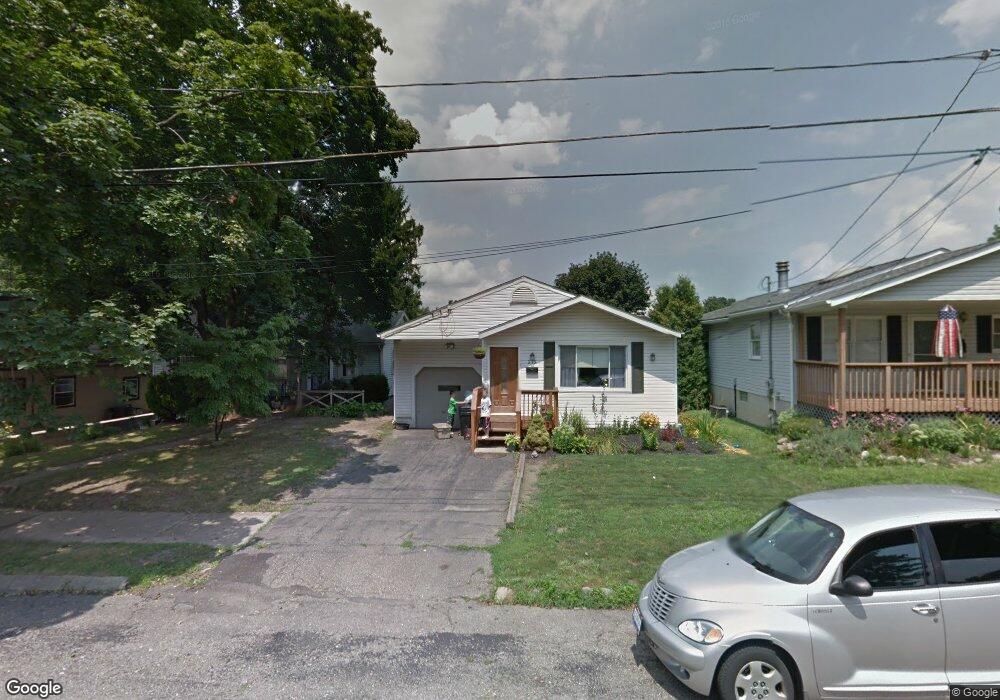
215 W Way St Barberton, OH 44203
North Barberton NeighborhoodEstimated Value: $149,386 - $164,000
3
Beds
1
Bath
1,225
Sq Ft
$127/Sq Ft
Est. Value
About This Home
This home is located at 215 W Way St, Barberton, OH 44203 and is currently estimated at $156,097, approximately $127 per square foot. 215 W Way St is a home located in Summit County with nearby schools including Barberton Middle School, Barberton Intermediate School 3-5, and Barberton High School.
Ownership History
Date
Name
Owned For
Owner Type
Purchase Details
Closed on
Jan 5, 2016
Sold by
Kurilko Todd M and Kurilko Todd M
Bought by
Kurilko Heather L
Current Estimated Value
Home Financials for this Owner
Home Financials are based on the most recent Mortgage that was taken out on this home.
Original Mortgage
$85,402
Interest Rate
3.62%
Mortgage Type
FHA
Purchase Details
Closed on
Aug 21, 2001
Sold by
Kurilko Albert H and Kurilko Carole
Bought by
Kurilko Todd M and Kurilko Heather L
Home Financials for this Owner
Home Financials are based on the most recent Mortgage that was taken out on this home.
Original Mortgage
$85,360
Interest Rate
7.28%
Purchase Details
Closed on
Nov 8, 1996
Sold by
Est Betty Kirk
Bought by
Kurilko Albert H and Kurilko Carole
Create a Home Valuation Report for This Property
The Home Valuation Report is an in-depth analysis detailing your home's value as well as a comparison with similar homes in the area
Home Values in the Area
Average Home Value in this Area
Purchase History
| Date | Buyer | Sale Price | Title Company |
|---|---|---|---|
| Kurilko Heather L | -- | None Available | |
| Kurilko Todd M | $88,000 | Midland Commerce Group | |
| Kurilko Albert H | $26,500 | -- |
Source: Public Records
Mortgage History
| Date | Status | Borrower | Loan Amount |
|---|---|---|---|
| Previous Owner | Kurilko Heather L | $85,402 | |
| Previous Owner | Kurilko Todd M | $85,360 |
Source: Public Records
Tax History Compared to Growth
Tax History
| Year | Tax Paid | Tax Assessment Tax Assessment Total Assessment is a certain percentage of the fair market value that is determined by local assessors to be the total taxable value of land and additions on the property. | Land | Improvement |
|---|---|---|---|---|
| 2025 | $1,850 | $36,029 | $8,029 | $28,000 |
| 2024 | $1,850 | $36,029 | $8,029 | $28,000 |
| 2023 | $1,850 | $36,029 | $8,029 | $28,000 |
| 2022 | $1,401 | $23,674 | $5,250 | $18,424 |
| 2021 | $1,400 | $23,674 | $5,250 | $18,424 |
| 2020 | $1,370 | $23,670 | $5,250 | $18,420 |
| 2019 | $1,657 | $25,930 | $4,620 | $21,310 |
| 2018 | $1,633 | $25,930 | $4,620 | $21,310 |
| 2017 | $1,610 | $25,930 | $4,620 | $21,310 |
| 2016 | $1,613 | $25,930 | $4,620 | $21,310 |
| 2015 | $1,610 | $25,930 | $4,620 | $21,310 |
| 2014 | $1,601 | $25,930 | $4,620 | $21,310 |
| 2013 | $1,627 | $27,320 | $4,620 | $22,700 |
Source: Public Records
Map
Nearby Homes
- 645 Madison Ave
- 690 Saint Clair Ave
- 103 Mitchell St
- 44 W Summit St
- 0 Wooster Rd N
- 613 Wooster Rd N
- 146 Hermann St
- 213 Hermann St
- 30 W Hiram St
- 818 N Summit St
- 250 Evergreen St
- 137 Hermann St
- 277 Glenn St
- 1924 Caroline Ave
- 1960 Newton St
- 412 Grandview Ave
- 143 Glenn St
- 320 Lincoln Ave Unit 322
- 46 Brown St
- 0 Romig Ave