Estimated Value: $273,000 - $311,659
3
Beds
2
Baths
1,852
Sq Ft
$160/Sq Ft
Est. Value
About This Home
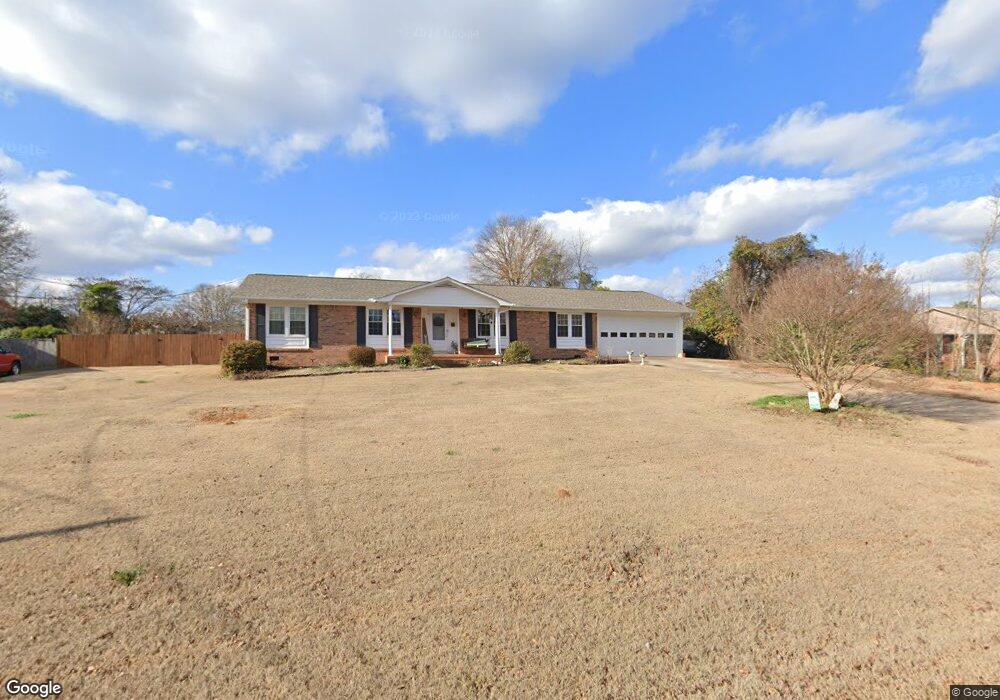
This home is located at 215 Wilson Rd, Greer, SC 29650 and is currently estimated at $295,665, approximately $159 per square foot. 215 Wilson Rd is a home located in Greenville County with nearby schools including Woodland Elementary School, Riverside Middle School, and Greer High School.
Ownership History
Date
Name
Owned For
Owner Type
Purchase Details
Closed on
Aug 24, 2023
Sold by
Dorn Dorothy M
Bought by
Gordon Michael and Gordon Janice
Current Estimated Value
Home Financials for this Owner
Home Financials are based on the most recent Mortgage that was taken out on this home.
Original Mortgage
$165,750
Outstanding Balance
$161,439
Interest Rate
6.96%
Mortgage Type
New Conventional
Estimated Equity
$134,226
Purchase Details
Closed on
Nov 9, 2007
Sold by
Dorn David W
Bought by
Dorn David W and Dorn Dorothy M
Home Financials for this Owner
Home Financials are based on the most recent Mortgage that was taken out on this home.
Original Mortgage
$135,000
Interest Rate
6.26%
Mortgage Type
Purchase Money Mortgage
Create a Home Valuation Report for This Property
The Home Valuation Report is an in-depth analysis detailing your home's value as well as a comparison with similar homes in the area
Home Values in the Area
Average Home Value in this Area
Purchase History
| Date | Buyer | Sale Price | Title Company |
|---|---|---|---|
| Gordon Michael | $221,000 | None Listed On Document | |
| Dorn David W | -- | None Available | |
| Dorn David W | -- | None Available |
Source: Public Records
Mortgage History
| Date | Status | Borrower | Loan Amount |
|---|---|---|---|
| Open | Gordon Michael | $165,750 | |
| Previous Owner | Dorn David W | $135,000 |
Source: Public Records
Tax History
| Year | Tax Paid | Tax Assessment Tax Assessment Total Assessment is a certain percentage of the fair market value that is determined by local assessors to be the total taxable value of land and additions on the property. | Land | Improvement |
|---|---|---|---|---|
| 2025 | $4,059 | $14,710 | $2,120 | $12,590 |
| 2024 | $4,059 | $12,800 | $1,980 | $10,820 |
| 2023 | $3,877 | $6,190 | $880 | $5,310 |
| 2022 | $880 | $6,190 | $880 | $5,310 |
| 2021 | $881 | $6,190 | $880 | $5,310 |
| 2020 | $888 | $5,910 | $880 | $5,030 |
| 2019 | $602 | $5,910 | $880 | $5,030 |
| 2018 | $600 | $5,910 | $880 | $5,030 |
| 2017 | $600 | $5,910 | $880 | $5,030 |
| 2016 | $567 | $147,820 | $22,000 | $125,820 |
| 2015 | $567 | $147,820 | $22,000 | $125,820 |
| 2014 | $575 | $149,670 | $22,000 | $127,670 |
Source: Public Records
Map
Nearby Homes
- 130 Marthawood Ln
- 402 Teresa Gem Ln
- 32 Country Dale Dr
- 912 S Main St
- 7 Country Dale Dr
- 209 Springdale Ave
- 211 Buncombe St
- 103 Hickory Rock Ln
- 125 Circle Dr
- 123 Circle Dr
- 202 Roscoe Dr
- 10 Bobo St
- 600 S Main St
- 304 Hickory Rock Ln
- 0 Golf St
- 214 Waverton Dr
- 00 Carey Ave
- 0 Carey Ave
- 303 Pennsylvania Ave
- 4 Jones Creek Cir
Your Personal Tour Guide
Ask me questions while you tour the home.