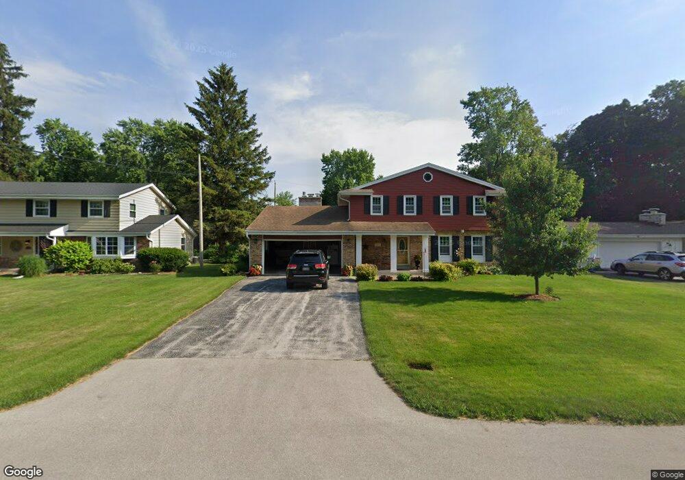
21515 Astolat Dr Brookfield, WI 53045
Estimated Value: $502,540 - $554,000
4
Beds
3
Baths
2,174
Sq Ft
$243/Sq Ft
Est. Value
About This Home
This home is located at 21515 Astolat Dr, Brookfield, WI 53045 and is currently estimated at $528,385, approximately $243 per square foot. 21515 Astolat Dr is a home located in Waukesha County with nearby schools including Brookfield Elementary School, Wisconsin Hills Middle School, and Brookfield Central High School.
Ownership History
Date
Name
Owned For
Owner Type
Purchase Details
Closed on
Sep 15, 2003
Sold by
Wing Elaine
Bought by
Below David S and Below Milene
Current Estimated Value
Home Financials for this Owner
Home Financials are based on the most recent Mortgage that was taken out on this home.
Original Mortgage
$185,000
Interest Rate
6.23%
Mortgage Type
Balloon
Purchase Details
Closed on
Sep 6, 1994
Sold by
Wing James D
Bought by
Wing Elaine and Elaine Wing Revocable Trust
Create a Home Valuation Report for This Property
The Home Valuation Report is an in-depth analysis detailing your home's value as well as a comparison with similar homes in the area
Home Values in the Area
Average Home Value in this Area
Purchase History
| Date | Buyer | Sale Price | Title Company |
|---|---|---|---|
| Below David S | $275,000 | Priority Title Corporation | |
| Wing Elaine | -- | -- |
Source: Public Records
Mortgage History
| Date | Status | Borrower | Loan Amount |
|---|---|---|---|
| Closed | Below David S | $185,000 |
Source: Public Records
Tax History
| Year | Tax Paid | Tax Assessment Tax Assessment Total Assessment is a certain percentage of the fair market value that is determined by local assessors to be the total taxable value of land and additions on the property. | Land | Improvement |
|---|---|---|---|---|
| 2024 | $4,331 | $392,400 | $125,000 | $267,400 |
| 2023 | $4,328 | $392,400 | $125,000 | $267,400 |
| 2022 | $4,491 | $318,000 | $110,000 | $208,000 |
| 2021 | $4,753 | $318,000 | $110,000 | $208,000 |
| 2020 | $4,972 | $318,000 | $110,000 | $208,000 |
| 2019 | $4,771 | $318,000 | $110,000 | $208,000 |
| 2018 | $4,542 | $294,500 | $110,000 | $184,500 |
| 2017 | $4,552 | $294,500 | $110,000 | $184,500 |
| 2016 | $4,618 | $294,500 | $110,000 | $184,500 |
| 2015 | $4,595 | $294,500 | $110,000 | $184,500 |
| 2014 | $4,766 | $294,500 | $110,000 | $184,500 |
| 2013 | $4,766 | $294,500 | $110,000 | $184,500 |
Source: Public Records
Map
Nearby Homes
- 2465 Lionel Ct
- 2550 Harmony Cir
- 2570 Gaywood Ct
- 1930 Cotton Tail Ln
- 21965 W North Ave
- N28W22131 Indianwood Ct
- W224N2507 Ridgewood Ln
- N29W22090 Kathryn Ct
- W221N3075 Greenwood Ct
- 1365 Poplar Ridge Ct
- Lt118 Berwick Ct
- Lt120 Berwick Ct
- Lt116 Berwick Ct
- Lt114 Berwick Ct
- 1825 Derrin Ln
- 1775 Derrin Ln
- 20300 Yorktown Ct
- 1045 Lansdowne Ct Unit V39
- 1040 Lansdowne Ct Unit V6
- 19775 Trilby Ct
- 21545 Astolat Dr
- 21485 Astolat Dr
- 21510 Lancelot Dr
- 21540 Lancelot Dr
- 21480 Lancelot Dr
- 21565 Astolat Dr
- 21455 Astolat Dr
- 21510 Astolat Dr
- 21540 Astolat Dr
- 21480 Astolat Dr
- 21560 Lancelot Dr
- 21450 Lancelot Dr
- 21560 Astolat Dr
- 21595 Astolat Dr
- 21435 Astolat Dr
- 21450 Astolat Dr
- 21590 Lancelot Dr
- 21430 Lancelot Dr
- 21590 Astolat Dr
- 21625 Astolat Dr
Your Personal Tour Guide
Ask me questions while you tour the home.