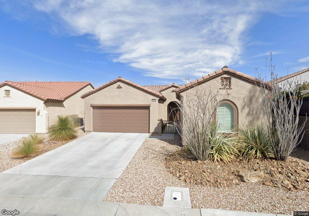
2154 Lewiston Place Henderson, NV 89044
Sun City Anthem NeighborhoodEstimated Value: $489,000 - $546,106
3
Beds
3
Baths
1,496
Sq Ft
$344/Sq Ft
Est. Value
About This Home
This home is located at 2154 Lewiston Place, Henderson, NV 89044 and is currently estimated at $514,777, approximately $344 per square foot. 2154 Lewiston Place is a home located in Clark County with nearby schools including Shirley & Bill Wallin Elementary School, Del E. Webb Middle School, and Liberty High School.
Ownership History
Date
Name
Owned For
Owner Type
Purchase Details
Closed on
Feb 28, 2006
Sold by
Del Webb Communities Inc
Bought by
Mersch Joseph and Mersch Janann
Current Estimated Value
Home Financials for this Owner
Home Financials are based on the most recent Mortgage that was taken out on this home.
Original Mortgage
$150,000
Outstanding Balance
$82,188
Interest Rate
6.04%
Mortgage Type
Fannie Mae Freddie Mac
Estimated Equity
$432,589
Create a Home Valuation Report for This Property
The Home Valuation Report is an in-depth analysis detailing your home's value as well as a comparison with similar homes in the area
Home Values in the Area
Average Home Value in this Area
Purchase History
| Date | Buyer | Sale Price | Title Company |
|---|---|---|---|
| Mersch Joseph | $332,836 | Lawyers Title |
Source: Public Records
Mortgage History
| Date | Status | Borrower | Loan Amount |
|---|---|---|---|
| Open | Mersch Joseph | $150,000 |
Source: Public Records
Tax History
| Year | Tax Paid | Tax Assessment Tax Assessment Total Assessment is a certain percentage of the fair market value that is determined by local assessors to be the total taxable value of land and additions on the property. | Land | Improvement |
|---|---|---|---|---|
| 2026 | $2,935 | $149,850 | $52,080 | $97,770 |
| 2025 | $2,849 | $150,250 | $50,400 | $99,850 |
| 2024 | $2,766 | $150,250 | $50,400 | $99,850 |
| 2023 | $2,766 | $140,930 | $47,250 | $93,680 |
| 2022 | $2,686 | $125,385 | $39,200 | $86,185 |
| 2021 | $2,608 | $115,390 | $33,950 | $81,440 |
| 2020 | $2,529 | $114,031 | $33,600 | $80,431 |
| 2019 | $2,455 | $110,964 | $31,500 | $79,464 |
| 2018 | $2,384 | $106,475 | $29,750 | $76,725 |
| 2017 | $3,072 | $105,034 | $28,000 | $77,034 |
| 2016 | $2,257 | $100,371 | $22,750 | $77,621 |
| 2015 | $2,251 | $92,139 | $15,750 | $76,389 |
| 2014 | $2,186 | $86,063 | $12,250 | $73,813 |
Source: Public Records
Map
Nearby Homes
- 2222 Bensley St
- 2167 Gunnison Place
- 2239 Shadow Canyon Dr
- 2203 Bannerwood St
- 2188 Bannerwood St
- 2181 Silent Echoes Dr
- 2159 Bensley St
- 2151 Bannerwood St
- 2148 Shadow Canyon Dr
- 2232 Canyonville Dr
- 2182 Sandstone Cliffs Dr
- 2175 Sandstone Cliffs Dr
- 2312 Perrysburg Dr
- 2348 Kalkaska Dr
- 2154 Burtonsville Dr
- 2240 Cordaville Dr
- 2258 Sandstone Cliffs Dr
- 2404 Anderson Park Dr
- 2100 Burtonsville Dr
- 2146 Idaho Falls Dr
- 2158 Lewiston Place
- 2251 Waynesboro Ct
- 2255 Waynesboro Ct
- 2162 Lewiston Place
- 2153 Cedar River Ct
- 2157 Cedar River Ct
- 2157 Cedar River Ct
- 2155 Lewiston Place
- 2161 Cedar River Ct
- 2163 Lewiston Place
- 2151 Lewiston Place
- 2247 Waynesboro Ct
- 2147 Lewiston Place
- 2143 Lewiston Place
- 2251 Bannerwood St
- 2259 Bannerwood St
- 2248 Waynesboro Ct
- 2256 Waynesboro Ct
- 2162 Gunnison Place Unit 1
- 2162 Gunnison Place
Your Personal Tour Guide
Ask me questions while you tour the home.