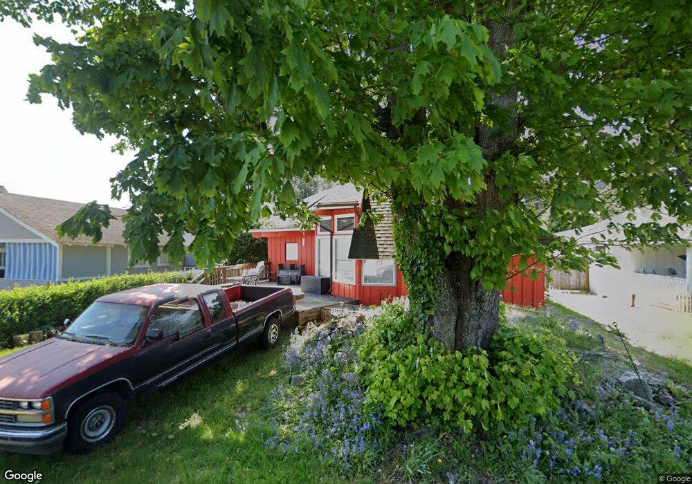
2155 Cedar St Point Roberts, WA 98281
Estimated Value: $433,339 - $454,000
4
Beds
1
Bath
1,216
Sq Ft
$365/Sq Ft
Est. Value
About This Home
This home is located at 2155 Cedar St, Point Roberts, WA 98281 and is currently estimated at $443,835, approximately $364 per square foot. 2155 Cedar St is a home located in Whatcom County with nearby schools including Point Roberts Primary School, Blaine Middle School, and Blaine High School.
Ownership History
Date
Name
Owned For
Owner Type
Purchase Details
Closed on
Jul 30, 2003
Sold by
Gauvin Glen A and Gauvin Kathleen A
Bought by
Evans Edward and Evans Frances
Current Estimated Value
Purchase Details
Closed on
Mar 22, 2000
Sold by
Associates Financial Svcs Of America Inc
Bought by
Gauvin Glen A and Gauvin Kathleen
Home Financials for this Owner
Home Financials are based on the most recent Mortgage that was taken out on this home.
Original Mortgage
$77,200
Interest Rate
7.75%
Purchase Details
Closed on
Jan 10, 2000
Sold by
Chernochan Robert A
Bought by
Associates Financial Svcs America Inc
Create a Home Valuation Report for This Property
The Home Valuation Report is an in-depth analysis detailing your home's value as well as a comparison with similar homes in the area
Home Values in the Area
Average Home Value in this Area
Purchase History
| Date | Buyer | Sale Price | Title Company |
|---|---|---|---|
| Evans Edward | -- | Whatcom Land Title | |
| Gauvin Glen A | $96,500 | First American Title Ins | |
| Associates Financial Svcs America Inc | $90,000 | Charter Title Corporation |
Source: Public Records
Mortgage History
| Date | Status | Borrower | Loan Amount |
|---|---|---|---|
| Previous Owner | Gauvin Glen A | $77,200 |
Source: Public Records
Tax History
| Year | Tax Paid | Tax Assessment Tax Assessment Total Assessment is a certain percentage of the fair market value that is determined by local assessors to be the total taxable value of land and additions on the property. | Land | Improvement |
|---|---|---|---|---|
| 2025 | $2,958 | $359,866 | $127,733 | $232,133 |
| 2024 | $2,854 | $356,297 | $126,473 | $229,824 |
| 2023 | $2,854 | $344,799 | $114,975 | $229,824 |
| 2022 | $2,668 | $314,885 | $105,000 | $209,885 |
| 2021 | $2,657 | $266,770 | $100,320 | $166,450 |
| 2020 | $2,645 | $247,006 | $92,888 | $154,118 |
| 2019 | $2,453 | $236,934 | $89,100 | $147,834 |
| 2018 | $2,343 | $213,001 | $80,100 | $132,901 |
| 2017 | $2,032 | $203,428 | $76,500 | $126,928 |
| 2016 | $2,075 | $199,439 | $75,000 | $124,439 |
| 2015 | $2,207 | $198,020 | $72,458 | $125,562 |
| 2014 | -- | $207,014 | $75,750 | $131,264 |
| 2013 | -- | $198,012 | $72,750 | $125,262 |
Source: Public Records
Map
Nearby Homes
- 103 Goodman Rd
- 0 3 73 Acres Derby Ave
- 0 15 Whalen Dr
- 19 Whalen Dr
- 251 Elizabeth Dr
- 1928 Sanders Ct Unit 2
- 2138 Benson Rd
- 1871 Johnson Rd
- 0 Deer Rd
- 6 Weasel Run Rd
- 1 Mill Rd
- 2 Mill Rd
- 245 Shady Glen Ave
- 25 Roosevelt Way
- 1774 Centennial Place
- 2045 Apa Rd
- 125 Park Dr
- 1940 Apa Rd
- 2202 Seabright Loop
- 58 Seabright Loop
Your Personal Tour Guide
Ask me questions while you tour the home.