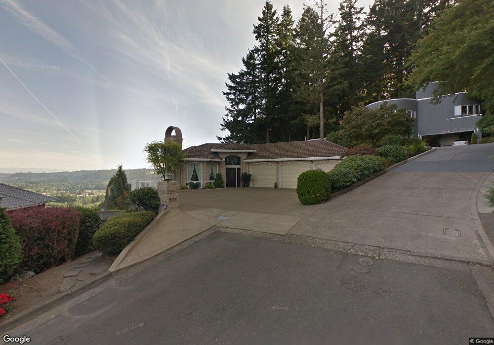
2155 Ridge Pointe Dr Lake Oswego, OR 97034
Palisades NeighborhoodEstimated Value: $1,313,586 - $2,007,000
3
Beds
3
Baths
3,396
Sq Ft
$477/Sq Ft
Est. Value
About This Home
This home is located at 2155 Ridge Pointe Dr, Lake Oswego, OR 97034 and is currently estimated at $1,618,647, approximately $476 per square foot. 2155 Ridge Pointe Dr is a home located in Clackamas County with nearby schools including Westridge Elementary School, Lakeridge Middle School, and Lakeridge High School.
Ownership History
Date
Name
Owned For
Owner Type
Purchase Details
Closed on
Jul 17, 2000
Sold by
Budden Moir M and Budden Sarojini S
Bought by
Budden Moir Mahendrakumar and Budden Sarojini Sylvia
Current Estimated Value
Purchase Details
Closed on
Sep 1, 1988
Bought by
Budden Moir Mahendrakumar Trustee
Create a Home Valuation Report for This Property
The Home Valuation Report is an in-depth analysis detailing your home's value as well as a comparison with similar homes in the area
Home Values in the Area
Average Home Value in this Area
Purchase History
| Date | Buyer | Sale Price | Title Company |
|---|---|---|---|
| Budden Moir Mahendrakumar | -- | -- | |
| Budden Moir Mahendrakumar Trustee | $76,000 | -- |
Source: Public Records
Tax History Compared to Growth
Tax History
| Year | Tax Paid | Tax Assessment Tax Assessment Total Assessment is a certain percentage of the fair market value that is determined by local assessors to be the total taxable value of land and additions on the property. | Land | Improvement |
|---|---|---|---|---|
| 2025 | $14,836 | $774,234 | -- | -- |
| 2024 | $14,440 | $751,684 | -- | -- |
| 2023 | $14,440 | $729,791 | $0 | $0 |
| 2022 | $13,600 | $708,535 | $0 | $0 |
| 2021 | $12,560 | $687,899 | $0 | $0 |
| 2020 | $12,245 | $667,864 | $0 | $0 |
| 2019 | $11,943 | $648,412 | $0 | $0 |
| 2018 | $11,357 | $629,526 | $0 | $0 |
| 2017 | $10,959 | $611,190 | $0 | $0 |
| 2016 | $9,975 | $593,388 | $0 | $0 |
| 2015 | $9,637 | $576,105 | $0 | $0 |
| 2014 | $9,513 | $559,325 | $0 | $0 |
Source: Public Records
Map
Nearby Homes
- 2306 Mayors Ln
- 17958 Saint Clair Dr
- 17901 Hillside Dr
- 1849 Cloverleaf Rd
- 17349 Banyan Ln
- 17677 Westview Dr
- 17360 Alpine Way
- 12 Dover Way
- 2627 Park Rd
- 1951 Greentree Rd
- 6 Westminster Dr
- 18815 Hilltop Rd
- 17422 Blue Heron Rd
- 2255 Glen Haven Rd
- 3140 SW Childs Rd
- 17035 Westview Dr
- 1931 Park Forest Ct
- 16878 Canyon Dr
- 17447 Blue Heron Rd
- 1550 Shadow Wood Dr
- 2145 Ridge Pointe Dr
- 18483 Ray Ridge Dr
- 18493 Ray Ridge Dr
- 2135 Ridge Pointe Dr
- 2125 Ridge Pointe Dr
- 18470 Ray Ridge Dr
- 18480 Ray Ridge Dr
- 18460 Ray Ridge Dr
- 18490 Ray Ridge Dr
- 18503 Ray Ridge Dr
- 18500 Ray Ridge Dr
- 2115 Ridge Pointe Dr
- 2110 Ridge Pointe Dr
- 1961 Cheryl Ct
- 1949 Cheryl Ct
- 1973 Cheryl Ct
- 1937 Cheryl Ct
- 2100 Ridge Pointe Dr
- 1972 Cheryl Ct
- 2105 Ridge Pointe Dr