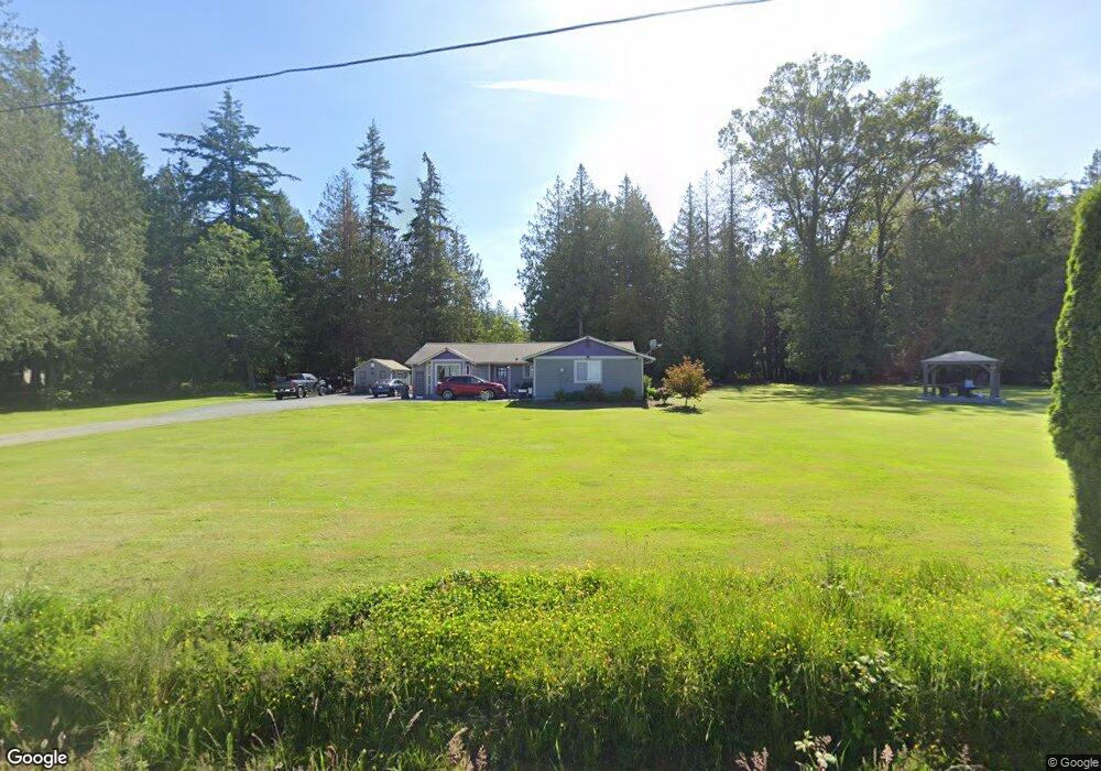
21567 Bulson Rd Mount Vernon, WA 98274
Estimated Value: $621,000 - $778,000
3
Beds
2
Baths
1,765
Sq Ft
$404/Sq Ft
Est. Value
About This Home
This home is located at 21567 Bulson Rd, Mount Vernon, WA 98274 and is currently estimated at $713,451, approximately $404 per square foot. 21567 Bulson Rd is a home located in Skagit County with nearby schools including Conway School.
Ownership History
Date
Name
Owned For
Owner Type
Purchase Details
Closed on
Nov 19, 2018
Sold by
Collart Gary Lee and Collart Beverley Ann
Bought by
Parker Elizabeth Marie Knight
Current Estimated Value
Home Financials for this Owner
Home Financials are based on the most recent Mortgage that was taken out on this home.
Original Mortgage
$295,250
Outstanding Balance
$259,082
Interest Rate
4.7%
Mortgage Type
New Conventional
Estimated Equity
$454,369
Create a Home Valuation Report for This Property
The Home Valuation Report is an in-depth analysis detailing your home's value as well as a comparison with similar homes in the area
Home Values in the Area
Average Home Value in this Area
Purchase History
| Date | Buyer | Sale Price | Title Company |
|---|---|---|---|
| Parker Elizabeth Marie Knight | $341,100 | Chicago Title |
Source: Public Records
Mortgage History
| Date | Status | Borrower | Loan Amount |
|---|---|---|---|
| Open | Parker Elizabeth Marie Knight | $295,250 |
Source: Public Records
Tax History Compared to Growth
Tax History
| Year | Tax Paid | Tax Assessment Tax Assessment Total Assessment is a certain percentage of the fair market value that is determined by local assessors to be the total taxable value of land and additions on the property. | Land | Improvement |
|---|---|---|---|---|
| 2024 | $5,307 | $631,700 | $279,900 | $351,800 |
| 2023 | $5,307 | $584,000 | $261,600 | $322,400 |
| 2022 | $4,691 | $605,400 | $263,600 | $341,800 |
| 2021 | $4,694 | $469,500 | $201,200 | $268,300 |
| 2020 | $4,378 | $434,800 | $0 | $0 |
| 2019 | $3,717 | $404,000 | $0 | $0 |
| 2018 | $4,195 | $347,600 | $0 | $0 |
| 2017 | $4,090 | $331,600 | $0 | $0 |
| 2016 | $3,947 | $325,700 | $136,700 | $189,000 |
| 2015 | $3,558 | $304,100 | $127,700 | $176,400 |
| 2013 | $3,638 | $253,600 | $0 | $0 |
Source: Public Records
Map
Nearby Homes
- 19687 Trophy Ln
- 22414 Bulson Rd
- 20616 Bulson Rd
- 22539 Fieldstone Ln
- 0 Milltown Crossing Rd Unit NWM2358059
- 18520 Main St
- 23158 Bonnieview Rd
- 21314 Starbird Rd
- 20519 Benson Ridge Ln
- 20434 Benson Ridge
- 20555 Benson Ridge
- 18524 Swanson Ln
- 17406 Fir Island Rd
- 33020 84th Ave NW
- 32210 68th Ave NW
- 3723 324th St NW
- 0 XX 00
- 5707 316th St NW
- 31614 60th Ave NW
- 23330 State Route 534
- 20036 English Rd
- 21614 Bulson Rd
- 21629 Bulson Rd
- 20100 English Rd
- 21496 Bulson Rd
- 20134 English Rd
- 20152 English Rd
- 21777 Bulson Rd
- 20095 English Rd
- 20209 English Rd
- 21368 Bulson Rd
- 20226 English Rd
- 21781 Bulson Rd
- 21818 Bulson Rd
- 20249 English Rd
- 21622 Bulson Rd
- 21815 Bulson Rd
- 21326 Bulson Rd
- 21618 Bulson Rd
- 20282 English Rd