
Seller's Agent in 2012
Darrin Kelleher
Cascade Hasson SIR
(541) 788-0029
29 Total Sales
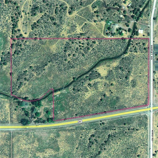
20.40 acres zoned EFU within the proposed Urban Growth Boundary.
Last Agent to Sell the Property
Cascade Hasson SIR License #200712093 Listed on: 05/15/2012
| Date | Buyer | Sale Price | Title Company |
|---|---|---|---|
| Eastside Bend Llc | $1,000,000 | Western Title & Escrow | |
| Desertscape Highway 20 North Llc | -- | None Available |
| Date | Status | Borrower | Loan Amount |
|---|---|---|---|
| Closed | Eastside Bend Llc | $915,000 |
| Date | Event | Price | List to Sale | Price per Sq Ft |
|---|---|---|---|---|
| 09/13/2012 09/13/12 | Sold | $408,000 | 0.0% | -- |
| 05/15/2012 05/15/12 | Pending | -- | -- | -- |
| 05/15/2012 05/15/12 | For Sale | $408,000 | -- | -- |
| Year | Tax Paid | Tax Assessment Tax Assessment Total Assessment is a certain percentage of the fair market value that is determined by local assessors to be the total taxable value of land and additions on the property. | Land | Improvement |
|---|---|---|---|---|
| 2025 | $1,899 | $114,680 | $114,680 | -- |
| 2024 | $1,820 | $111,340 | $111,340 | -- |
| 2023 | $1,719 | $108,100 | $108,100 | $0 |
| 2022 | $2,069 | $132,740 | $0 | $0 |
| 2021 | $2,081 | $128,880 | $0 | $0 |
| 2020 | $1,973 | $128,880 | $0 | $0 |
| 2019 | $1,917 | $125,130 | $0 | $0 |
| 2018 | $1,862 | $121,490 | $0 | $0 |
| 2017 | $1,813 | $117,960 | $0 | $0 |
| 2016 | $1,728 | $114,530 | $0 | $0 |
| 2015 | $1,679 | $111,200 | $0 | $0 |
| 2014 | $1,628 | $107,970 | $0 | $0 |
Seller's Agent in 2012
Darrin Kelleher
Cascade Hasson SIR
(541) 788-0029
29 Total Sales
Seller Co-Listing Agent in 2012
Angela Mombert
RE/MAX
(541) 408-3543
186 Total Sales
Source: Oregon Datashare
MLS Number: 201203941
APN: 125140
Disclaimer: Certain information contained herein is derived from information provided by parties other than Homes.com. All information provided is deemed reliable, but is not guaranteed to be accurate and should be independently verified.
![]() © 2026 Oregon Datashare (KCAR | MLSCO | SOMLS). All rights reserved. The data relating to real estate for sale on this web site comes in part from the Internet Data Exchange Program of the Oregon Datashare. Real estate listings held by IDX Brokerage firms other than Ten-X are marked with the Internet Data Exchange logo or the Internet Data Exchange thumbnail logo and detailed information about them includes the name of the listing Brokers. Information provided is for consumers' personal, non-commercial use and may not be used for any purpose other than to identify prospective properties the viewer may be interested in purchasing. The consumer will not copy, retransmit nor redistribute any of the content from this website. Information provided is deemed reliable, but not guaranteed.
© 2026 Oregon Datashare (KCAR | MLSCO | SOMLS). All rights reserved. The data relating to real estate for sale on this web site comes in part from the Internet Data Exchange Program of the Oregon Datashare. Real estate listings held by IDX Brokerage firms other than Ten-X are marked with the Internet Data Exchange logo or the Internet Data Exchange thumbnail logo and detailed information about them includes the name of the listing Brokers. Information provided is for consumers' personal, non-commercial use and may not be used for any purpose other than to identify prospective properties the viewer may be interested in purchasing. The consumer will not copy, retransmit nor redistribute any of the content from this website. Information provided is deemed reliable, but not guaranteed.