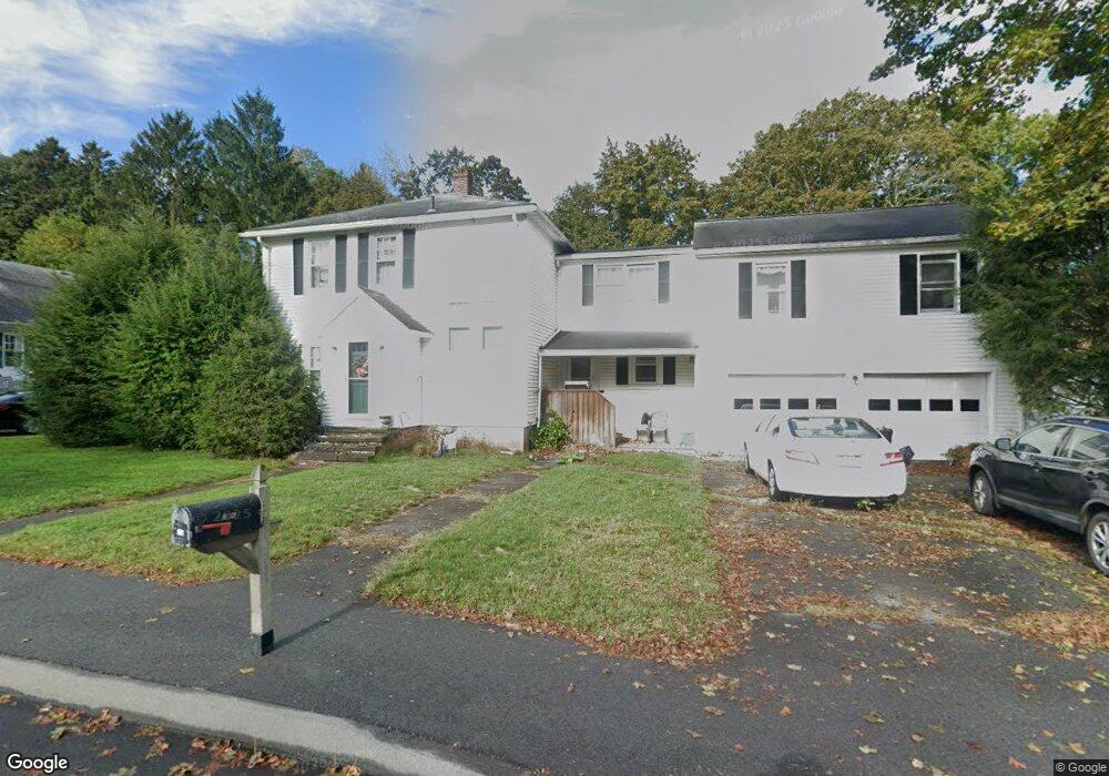
216 Andrews St North Dighton, MA 02764
Estimated Value: $581,000 - $659,000
4
Beds
3
Baths
2,588
Sq Ft
$239/Sq Ft
Est. Value
About This Home
This home is located at 216 Andrews St, North Dighton, MA 02764 and is currently estimated at $618,917, approximately $239 per square foot. 216 Andrews St is a home located in Bristol County with nearby schools including Dighton-Rehoboth Regional High School and Our Lady of Lourdes School.
Ownership History
Date
Name
Owned For
Owner Type
Purchase Details
Closed on
May 12, 2010
Sold by
Hubbard William F
Bought by
Hubbard Leeanne
Current Estimated Value
Purchase Details
Closed on
Mar 9, 2010
Sold by
Brezinski Donna L
Bought by
Hubbard William F
Home Financials for this Owner
Home Financials are based on the most recent Mortgage that was taken out on this home.
Original Mortgage
$130,000
Interest Rate
5%
Mortgage Type
Purchase Money Mortgage
Create a Home Valuation Report for This Property
The Home Valuation Report is an in-depth analysis detailing your home's value as well as a comparison with similar homes in the area
Home Values in the Area
Average Home Value in this Area
Purchase History
| Date | Buyer | Sale Price | Title Company |
|---|---|---|---|
| Hubbard Leeanne | -- | -- | |
| Hubbard William F | $40,190 | -- |
Source: Public Records
Mortgage History
| Date | Status | Borrower | Loan Amount |
|---|---|---|---|
| Previous Owner | Hubbard William F | $130,000 |
Source: Public Records
Tax History Compared to Growth
Tax History
| Year | Tax Paid | Tax Assessment Tax Assessment Total Assessment is a certain percentage of the fair market value that is determined by local assessors to be the total taxable value of land and additions on the property. | Land | Improvement |
|---|---|---|---|---|
| 2025 | $6,359 | $506,300 | $113,900 | $392,400 |
| 2024 | $6,241 | $456,200 | $113,900 | $342,300 |
| 2023 | $5,859 | $420,300 | $113,900 | $306,400 |
| 2022 | $5,592 | $391,300 | $111,100 | $280,200 |
| 2021 | $5,293 | $356,900 | $100,000 | $256,900 |
| 2020 | $5,325 | $355,500 | $112,100 | $243,400 |
| 2019 | $4,909 | $327,500 | $112,100 | $215,400 |
| 2018 | $4,593 | $308,900 | $95,000 | $213,900 |
| 2017 | $4,277 | $286,300 | $110,600 | $175,700 |
| 2016 | $4,226 | $277,500 | $113,900 | $163,600 |
| 2015 | $4,005 | $270,600 | $117,300 | $153,300 |
| 2014 | $3,986 | $261,700 | $117,300 | $144,400 |
Source: Public Records
Map
Nearby Homes
- 0 Andrews St
- 238 Andrews St
- 698 School St Unit 698
- 221 Summer St
- 0 Summer St
- 233-R Summer St
- 876 Autumn St
- 343 Forest St
- 441 Forest St
- 810 Tremont St
- 1472 Somerset Ave
- 1026 Tremont St
- 322 Dighton Ave
- 15 Shetland Rd
- 154 Appaloosa Way
- 410 Warner Blvd Unit A
- 969 Somerset Ave
- 58 Lawton St
- 4 A Lawton St Unit A
- 38 Cranesbill Rd