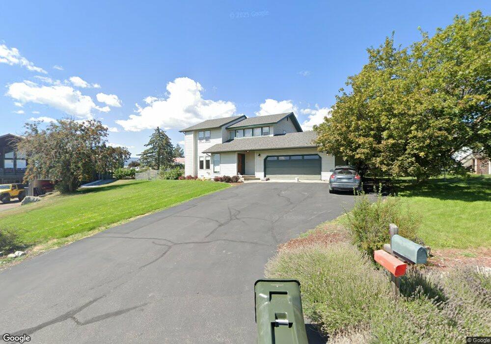
216 Apple Tree Cir Kalispell, MT 59901
Estimated Value: $530,803 - $626,000
3
Beds
3
Baths
1,982
Sq Ft
$286/Sq Ft
Est. Value
About This Home
This home is located at 216 Apple Tree Cir, Kalispell, MT 59901 and is currently estimated at $565,951, approximately $285 per square foot. 216 Apple Tree Cir is a home located in Flathead County with nearby schools including Lillian Peterson School, Kalispell Middle School, and Flathead High School.
Ownership History
Date
Name
Owned For
Owner Type
Purchase Details
Closed on
Jan 31, 2025
Sold by
Hensler Michael E
Bought by
Hensler Michael E and Krautbauer Elizabeth M
Current Estimated Value
Purchase Details
Closed on
Jul 8, 2019
Sold by
Williams James S and Williams Melora A
Bought by
Hensler Michael E
Home Financials for this Owner
Home Financials are based on the most recent Mortgage that was taken out on this home.
Original Mortgage
$125,000
Interest Rate
4%
Mortgage Type
New Conventional
Create a Home Valuation Report for This Property
The Home Valuation Report is an in-depth analysis detailing your home's value as well as a comparison with similar homes in the area
Purchase History
| Date | Buyer | Sale Price | Title Company |
|---|---|---|---|
| Hensler Michael E | -- | None Listed On Document | |
| Hensler Michael E | -- | None Available |
Source: Public Records
Mortgage History
| Date | Status | Borrower | Loan Amount |
|---|---|---|---|
| Previous Owner | Hensler Michael E | $125,000 |
Source: Public Records
Tax History
| Year | Tax Paid | Tax Assessment Tax Assessment Total Assessment is a certain percentage of the fair market value that is determined by local assessors to be the total taxable value of land and additions on the property. | Land | Improvement |
|---|---|---|---|---|
| 2025 | $2,096 | $532,200 | $0 | $0 |
| 2024 | $2,862 | $448,300 | $0 | $0 |
| 2023 | $3,771 | $448,300 | $0 | $0 |
| 2022 | $2,813 | $330,900 | $0 | $0 |
| 2021 | $2,949 | $330,900 | $0 | $0 |
| 2020 | $2,513 | $272,200 | $0 | $0 |
| 2019 | $2,240 | $241,400 | $0 | $0 |
| 2018 | $2,178 | $224,800 | $0 | $0 |
| 2017 | $2,188 | $224,800 | $0 | $0 |
| 2016 | $1,772 | $199,700 | $0 | $0 |
| 2015 | $1,801 | $199,700 | $0 | $0 |
| 2014 | $1,725 | $114,692 | $0 | $0 |
Source: Public Records
Map
Nearby Homes
- 120 Midale St
- 539 Hun Ln
- 1695 Whalebone Dr
- 185 Hidden Waters Ln
- 170 Aspen Loop
- 270 Westland Dr
- 200 Aspen Loop
- 2845 Farm To Market Rd
- 2130 Farm To Market Rd
- 28 W Ashley Hills Dr
- 408 Needlegrass Ln
- 413 Needlegrass Ln
- 425 Needlegrass Ln
- 417 Needlegrass Ln
- 405 Needlegrass Ln
- 404 Needlegrass Ln
- 1264 Morning Eagle Dr
- 255 Triple Creek Dr
- 1272 Morning Eagle Dr
- 803 2 Mile Dr
- 212 Apple Tree Cir
- 220 Apple Tree Cir
- 217 W Spring Creek Rd
- 208 Apple Tree Cir
- 217 Apple Tree Cir
- 494 Yodelin Ridge Rd
- 479 Yodelin Ridge Rd
- 213 W Springcreek Rd
- 213 Apple Tree Cir
- 489 Yodelin Ridge Rd
- 211 W Springcreek Rd
- 469 Yodelin Ridge Rd
- 204 Apple Tree Cir
- 209 Apple Tree Cir
- 499 Yodelin Ridge Rd
- 205 Apple Tree Cir
- 390 Yodelin Ridge Rd
- 200 Apple Tree Cir
- 470 Meadow Hills Dr
- 460 Meadow Hills Dr
Your Personal Tour Guide
Ask me questions while you tour the home.