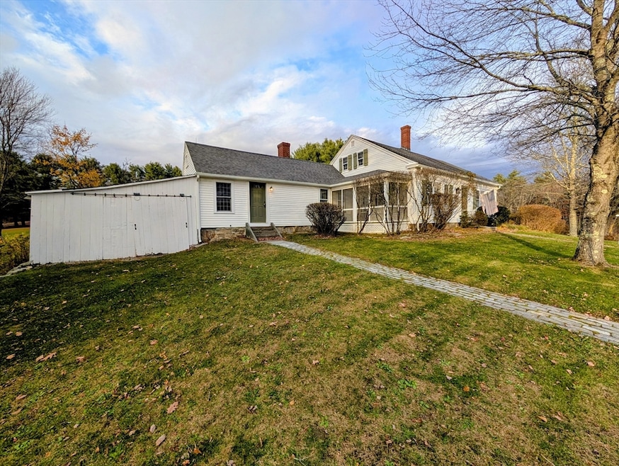

216 Brookfield Rd Charlton, MA 01507
Estimated payment $2,755/month
Highlights
- Golf Course Community
- Medical Services
- Open Floorplan
- Horses Allowed On Property
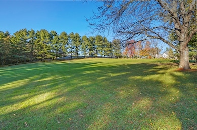
- 3 Acre Lot
- Custom Closet System
About This Home
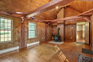
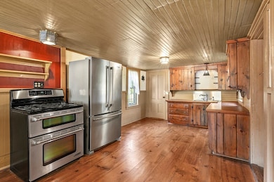
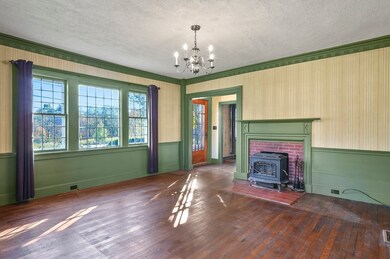
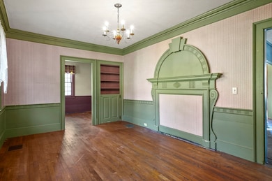
Lovingly maintained & renovated antique home was originally built around 1796! "The Sunset Hill Home" has many orig. features w/ modern updates to the electrical, framing, roof, plumbing, well & heating systems. Warm welcome into cathedral family room with pine floors & woodstove or main foyer with tin ceiling. Country kitchen w/ pantry & separate laundry room. Stone hearth remains in DR & has access to a screened porch. The main BR has incredible built in headboard & w.i.c. w/ a 2nd room that could be a nursery, office or BR. The 2nd floor has 2 rooms. This corner lot to desirable Jennings Dr subdivision has a beautiful, large yard, dotted with fruit trees, an established asparagus patch & raspberry bushes. Pretty stone walls & Cobblestone walks. Title 5 is done & a high-tech UV light filter was added to the well. Rare crown molding & built-in headboard! Plan time for showings to appreciate the care this home has had. This unique home is in move-in condition! Quick close.
Home Details
Home Type
- Single Family
Est. Annual Taxes
- $4,820
Year Built
- Built in 1791 | Remodeled
Lot Details
- 3 Acre Lot
- Stone Wall
- Corner Lot
- Fruit Trees
- Garden
Parking
- 1 Car Detached Garage
- Workshop in Garage
- Stone Driveway
- Unpaved Parking
- Open Parking
- Off-Street Parking
Home Design
- Cape Cod Architecture
- Colonial Architecture
- Federal Architecture
- Post and Beam
- Antique Architecture
- Farmhouse Style Home
- Stone Foundation
- Frame Construction
- Blown-In Insulation
- Shingle Roof
Interior Spaces
- 2,264 Sq Ft Home
- Open Floorplan
- Crown Molding
- Wainscoting
- Beamed Ceilings
- Cathedral Ceiling
- Wood Burning Stove
- Flue
- Family Room with Fireplace
- 3 Fireplaces
- Home Office
- Screened Porch
- Attic Access Panel
- Storm Windows
Kitchen
- Country Kitchen
- Stove
- Range
- Laminate Countertops
Flooring
- Wood
- Pine Flooring
- Vinyl
Bedrooms and Bathrooms
- 3 Bedrooms
- Primary Bedroom on Main
- Custom Closet System
- Walk-In Closet
- 1 Full Bathroom
- Pedestal Sink
- Bathtub
Laundry
- Laundry Room
- Laundry on main level
- Dryer
- Washer
Unfinished Basement
- Walk-Out Basement
- Partial Basement
- Interior and Exterior Basement Entry
- Sump Pump
- Dirt Floor
- Block Basement Construction
- Crawl Space
Outdoor Features
- Bulkhead
- Patio
- Outdoor Storage
- Rain Gutters
Location
- Property is near public transit
- Property is near schools
Schools
- Char Elementary School
- Charlton Middle School
- Shepherd Hl/Bp High School
Horse Facilities and Amenities
- Horses Allowed On Property
Utilities
- Forced Air Heating and Cooling System
- 1 Cooling Zone
- Wood Insert Heater
- 5 Heating Zones
- Heating System Uses Oil
- Pellet Stove burns compressed wood to generate heat
- Electric Baseboard Heater
- Generator Hookup
- 100 Amp Service
- Power Generator
- Water Treatment System
- Private Water Source
- Water Heater
- Private Sewer
Listing and Financial Details
- Legal Lot and Block 13 / A
- Assessor Parcel Number M:0015 B:000A L:0000013,1477939
Community Details
Overview
- No Home Owners Association
- Sunset Hill Farm Subdivision
Amenities
- Medical Services
- Shops
- Coin Laundry
Recreation
- Golf Course Community
Map
Home Values in the Area
Average Home Value in this Area
Tax History
| Year | Tax Paid | Tax Assessment Tax Assessment Total Assessment is a certain percentage of the fair market value that is determined by local assessors to be the total taxable value of land and additions on the property. | Land | Improvement |
|---|---|---|---|---|
| 2025 | $4,820 | $433,100 | $89,500 | $343,600 |
| 2024 | $4,682 | $412,900 | $86,100 | $326,800 |
| 2023 | $4,525 | $371,800 | $80,700 | $291,100 |
| 2022 | $3,671 | $276,200 | $78,700 | $197,500 |
| 2021 | $3,759 | $250,400 | $76,900 | $173,500 |
| 2020 | $3,651 | $244,400 | $70,900 | $173,500 |
| 2019 | $3,610 | $244,400 | $70,900 | $173,500 |
| 2018 | $3,299 | $244,400 | $70,900 | $173,500 |
| 2017 | $2,957 | $209,700 | $64,900 | $144,800 |
| 2016 | $2,890 | $209,700 | $64,900 | $144,800 |
| 2015 | $2,814 | $209,700 | $64,900 | $144,800 |
| 2014 | $2,647 | $209,100 | $69,200 | $139,900 |
Property History
| Date | Event | Price | List to Sale | Price per Sq Ft |
|---|---|---|---|---|
| 11/11/2025 11/11/25 | Pending | -- | -- | -- |
| 11/05/2025 11/05/25 | Price Changed | $446,900 | -6.9% | $197 / Sq Ft |
| 10/10/2025 10/10/25 | For Sale | $479,900 | -- | $212 / Sq Ft |
Purchase History
| Date | Type | Sale Price | Title Company |
|---|---|---|---|
| Quit Claim Deed | -- | None Available | |
| Quit Claim Deed | -- | None Available | |
| Deed | $170,000 | -- | |
| Deed | $170,000 | -- |
Mortgage History
| Date | Status | Loan Amount | Loan Type |
|---|---|---|---|
| Previous Owner | $150,000 | No Value Available | |
| Previous Owner | $150,000 | Purchase Money Mortgage |
Source: MLS Property Information Network (MLS PIN)
MLS Number: 73442233
APN: CHAR-000015-A000000-000013
Disclaimer: Certain information contained herein is derived from information provided by parties other than Homes.com. All information provided is deemed reliable, but is not guaranteed to be accurate and should be independently verified.
![]() The property listing data and information, or the Images, set forth herein were provided to MLS Property Information Network, Inc. from third party sources, including sellers, lessors and public records, and were compiled by MLS Property Information Network, Inc. The property listing data and information, and the Images, are for the personal, non-commercial use of consumers having a good faith interest in purchasing or leasing listed properties of the type displayed to them and may not be used for any purpose other than to identify prospective properties which such consumers may have a good faith interest in purchasing or leasing. MLS Property Information Network, Inc. and its subscribers disclaim any and all representations and warranties as to the accuracy of the property listing data and information, or as to the accuracy of any of the Images, set forth herein.
The property listing data and information, or the Images, set forth herein were provided to MLS Property Information Network, Inc. from third party sources, including sellers, lessors and public records, and were compiled by MLS Property Information Network, Inc. The property listing data and information, and the Images, are for the personal, non-commercial use of consumers having a good faith interest in purchasing or leasing listed properties of the type displayed to them and may not be used for any purpose other than to identify prospective properties which such consumers may have a good faith interest in purchasing or leasing. MLS Property Information Network, Inc. and its subscribers disclaim any and all representations and warranties as to the accuracy of the property listing data and information, or as to the accuracy of any of the Images, set forth herein.
- 204 Brookfield Rd
- 45 Jennings Rd
- 49 Jennings Rd
- 48 Jennings Rd
- 38 N Sullivan Rd
- Lot 3 0 N Sullivan Rd
- Lot 6 0 N Sullivan Rd
- Lot 5 0 N Sullivan Rd
- Lot 4 0 N Sullivan Rd
- 29, 31, 33 Ladd Rd
- 6 S Sullivan Rd
- 68 - 74 Sturbridge Rd
- Lot 0 N Sturbridge Rd
- 208 Sunset Dr
- 150 Podunk Rd
- 38 Stevens Park Rd
- 3 Cranberry Meadow Shore Rd
- 0 Worcester Rd
- 28 Southbridge Rd Unit 402
- 5 Carpenter Hill Rd
