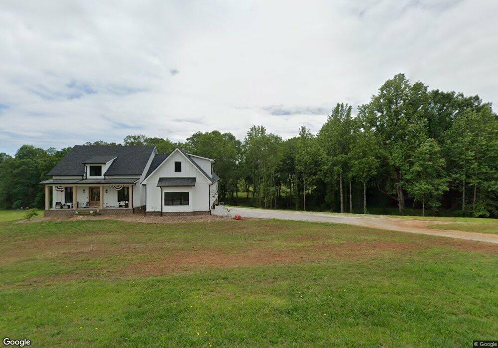
216 Brookridge Dr West Union, SC 29696
Estimated Value: $547,000 - $735,000
3
Beds
2
Baths
4,562
Sq Ft
$139/Sq Ft
Est. Value
About This Home
This home is located at 216 Brookridge Dr, West Union, SC 29696 and is currently estimated at $634,025, approximately $138 per square foot. 216 Brookridge Dr is a home with nearby schools including Walhalla Elementary School, Walhalla Middle School, and Walhalla High School.
Ownership History
Date
Name
Owned For
Owner Type
Purchase Details
Closed on
Jul 31, 2020
Sold by
Crowe Jason M
Bought by
Crowe Jason M and Crowe Courtney
Current Estimated Value
Purchase Details
Closed on
Feb 5, 2020
Sold by
Crowe Jack M and Crowe Teresa H
Bought by
Crowe Jason M
Purchase Details
Closed on
Nov 6, 2017
Sold by
Crowe Randy H and Crowe Angela D
Bought by
Crowe Jack M and Crowe Teresa H
Purchase Details
Closed on
Aug 14, 2008
Sold by
Honea Tony Lane
Bought by
Crowe Randy H and Crowe Angela D
Create a Home Valuation Report for This Property
The Home Valuation Report is an in-depth analysis detailing your home's value as well as a comparison with similar homes in the area
Home Values in the Area
Average Home Value in this Area
Purchase History
| Date | Buyer | Sale Price | Title Company |
|---|---|---|---|
| Crowe Jason M | -- | None Available | |
| Crowe Jason M | -- | None Available | |
| Crowe Jack M | $30,000 | None Available | |
| Crowe Randy H | $55,000 | -- |
Source: Public Records
Tax History
| Year | Tax Paid | Tax Assessment Tax Assessment Total Assessment is a certain percentage of the fair market value that is determined by local assessors to be the total taxable value of land and additions on the property. | Land | Improvement |
|---|---|---|---|---|
| 2025 | $2,011 | $19,174 | $1,410 | $17,764 |
| 2024 | $2,011 | $19,174 | $1,410 | $17,764 |
| 2023 | $2,038 | $19,174 | $1,410 | $17,764 |
| 2022 | $6,267 | $19,174 | $1,410 | $17,764 |
| 2021 | $483 | $1,410 | $1,410 | $0 |
| 2020 | $483 | $0 | $0 | $0 |
| 2019 | $483 | $0 | $0 | $0 |
| 2018 | $470 | $0 | $0 | $0 |
| 2017 | $712 | $0 | $0 | $0 |
| 2016 | $712 | $0 | $0 | $0 |
| 2015 | -- | $0 | $0 | $0 |
| 2014 | -- | $3,312 | $3,312 | $0 |
| 2013 | -- | $0 | $0 | $0 |
Source: Public Records
Map
Nearby Homes
- Lot 7 Winstead Rd
- 130 Raleighs Ln
- 621 Burns Mill Rd
- 115 Blue Ridge Riding Club Rd
- 00 Eleanore Dr
- 437 Burns Mill Rd
- 108 Cranes Crossing Dr
- 00 Heaven View Dr
- 665 Brc Dr
- 130 Russet Rd
- 132 Russet Rd
- 147 White Oak St
- 229 Cub Cove Dr
- 000 Wolf Stake Church Rd
- 00 Fox Run Rd
- 323 Fox Run Rd
- Lot 57 Fox Run Rd
- 221 Cub Cove Dr
- 302 Meadowlark Ln
- 106 Madison Dr
- 215 Brookridge Dr
- 214 Brookridge Dr
- 217 Brookridge Dr
- 218 Brookridge Dr
- 131 Brookside Dr
- 127 Brookside Dr
- 212 Brookridge Dr
- 219 Brookridge Dr
- 111 Brookside Dr
- 145 Brookside Dr
- 361 Winstead Rd
- 2327 N Highway 11
- 210 Brookridge Dr
- 349 Winstead Rd Unit LOT H
- 209 Brookridge Dr
- 359 Winstead Rd
- 137 Brookside Dr
- 341 Winstead Rd Unit LOT G
- 341 Winstead Rd
- 205 Brookridge Dr
Your Personal Tour Guide
Ask me questions while you tour the home.