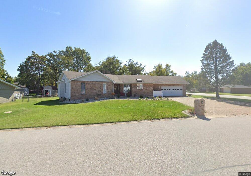
216 Chapel Dr Collinsville, IL 62234
Estimated Value: $227,000 - $303,000
4
Beds
2
Baths
1,676
Sq Ft
$161/Sq Ft
Est. Value
About This Home
This home is located at 216 Chapel Dr, Collinsville, IL 62234 and is currently estimated at $269,986, approximately $161 per square foot. 216 Chapel Dr is a home located in Madison County with nearby schools including John A Renfro Elementary School, Dorris Intermediate School, and Collinsville Middle School.
Ownership History
Date
Name
Owned For
Owner Type
Purchase Details
Closed on
Dec 10, 2020
Sold by
Wenos Trust
Bought by
Buente Laurie A
Current Estimated Value
Purchase Details
Closed on
Sep 21, 2016
Sold by
Wenos Herman J and Fiudo Wenos Madeleine M
Bought by
Herman J Wenos Revocable Trust
Purchase Details
Closed on
May 22, 2009
Sold by
Wenos Herman J and Wenos Mary M
Bought by
Herman J Wenos Revocable Trust
Purchase Details
Closed on
Apr 3, 2009
Sold by
Wenos Herman J and Wenos Mary M
Bought by
Herman J Wenos Revocable Trust
Create a Home Valuation Report for This Property
The Home Valuation Report is an in-depth analysis detailing your home's value as well as a comparison with similar homes in the area
Home Values in the Area
Average Home Value in this Area
Purchase History
| Date | Buyer | Sale Price | Title Company |
|---|---|---|---|
| Buente Laurie A | -- | None Available | |
| Herman J Wenos Revocable Trust | -- | None Available | |
| Herman J Wenos Revocable Trust | -- | None Available | |
| Herman J Wenos Revocable Trust | -- | None Available |
Source: Public Records
Tax History Compared to Growth
Tax History
| Year | Tax Paid | Tax Assessment Tax Assessment Total Assessment is a certain percentage of the fair market value that is determined by local assessors to be the total taxable value of land and additions on the property. | Land | Improvement |
|---|---|---|---|---|
| 2024 | $5,054 | $85,060 | $14,650 | $70,410 |
| 2023 | $5,054 | $77,780 | $13,330 | $64,450 |
| 2022 | $4,724 | $71,930 | $12,330 | $59,600 |
| 2021 | $4,253 | $67,570 | $11,580 | $55,990 |
| 2020 | $4,500 | $64,470 | $11,050 | $53,420 |
| 2019 | $4,204 | $59,750 | $10,310 | $49,440 |
| 2018 | $4,109 | $56,600 | $9,770 | $46,830 |
| 2017 | $4,117 | $55,480 | $9,580 | $45,900 |
| 2016 | $4,336 | $55,480 | $9,580 | $45,900 |
| 2015 | $4,016 | $54,040 | $9,330 | $44,710 |
| 2014 | $4,016 | $54,040 | $9,330 | $44,710 |
| 2013 | $4,016 | $54,040 | $9,330 | $44,710 |
Source: Public Records
Map
Nearby Homes
- 414 Bunker Hill Dr
- 0 N Keebler Ave
- 22 Brookwood Dr
- 1224 Cedar Ridge Ct
- 10 White Lily Dr
- 5 Brookwood Dr
- 203 Greenfield Dr
- 1120 Williams St
- 308 Brown Ave
- 1210 Constance St
- 617 N Morrison Ave
- 2007 Belt Line Rd
- 123 Elliot St
- 1121 Carraway Ct
- 0 Strong Ave
- 123 W Wickliffe Ave
- 501 Spring
- 706 Illinois Ave
- 102 Toni Ct
- 625 W Country Ln
- 302 Bridle Ridge Rd
- 214 Chapel Dr
- xx Chapel Dr
- 301 Bridle Ridge Rd
- 212 Chapel Dr
- 202 Bridle Ridge Rd
- 304 Bridle Ridge Rd
- 303 Chapel Dr
- 211 Yorktown Dr
- 303 Bridle Ridge Rd
- 209 Yorktown Dr
- 213 Chapel Dr
- 203 Bridle Ridge Rd
- 210 Chapel Dr
- 306 Bridle Ridge Rd
- 110 Lexington Dr
- 305 Bridle Ridge Rd
- 200 Bridle Ridge Rd
- 100 Lexington Dr
- 401 Chapel Dr