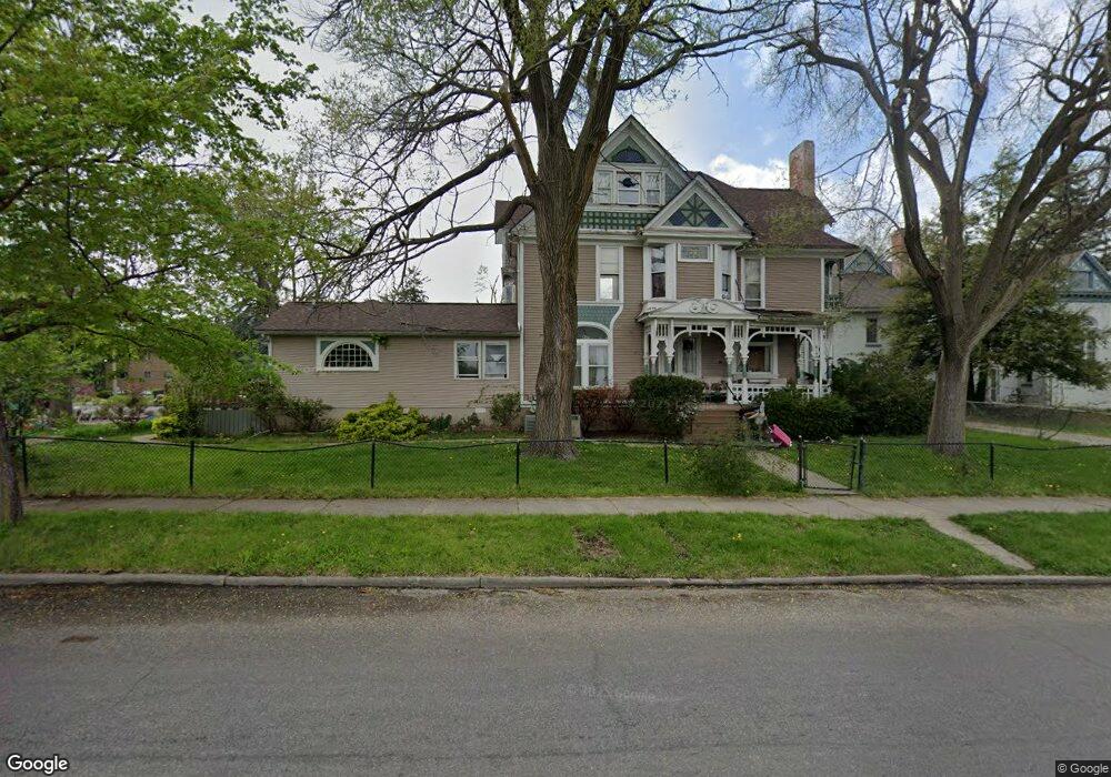
216 Division St Adrian, MI 49221
Estimated Value: $215,000 - $309,000
5
Beds
3
Baths
4,539
Sq Ft
$55/Sq Ft
Est. Value
About This Home
This home is located at 216 Division St, Adrian, MI 49221 and is currently estimated at $249,889, approximately $55 per square foot. 216 Division St is a home located in Lenawee County with nearby schools including Adrian High School and Berean Baptist Academy.
Ownership History
Date
Name
Owned For
Owner Type
Purchase Details
Closed on
Mar 3, 2020
Sold by
Thomas Opal
Bought by
Thomas Alexis O and Thomas Ciara R
Current Estimated Value
Purchase Details
Closed on
Oct 29, 2010
Sold by
Rice Marge and Welsh Sally
Bought by
Thomas Opal
Home Financials for this Owner
Home Financials are based on the most recent Mortgage that was taken out on this home.
Original Mortgage
$102,600
Interest Rate
6%
Mortgage Type
Adjustable Rate Mortgage/ARM
Purchase Details
Closed on
Mar 26, 2008
Sold by
Lighthouse Inn Program Inc
Bought by
Recovery Lifestyles Inc
Create a Home Valuation Report for This Property
The Home Valuation Report is an in-depth analysis detailing your home's value as well as a comparison with similar homes in the area
Home Values in the Area
Average Home Value in this Area
Purchase History
| Date | Buyer | Sale Price | Title Company |
|---|---|---|---|
| Thomas Alexis O | -- | None Available | |
| Thomas Opal | $108,000 | Atcl | |
| Recovery Lifestyles Inc | -- | None Available |
Source: Public Records
Mortgage History
| Date | Status | Borrower | Loan Amount |
|---|---|---|---|
| Previous Owner | Thomas Opal | $102,600 |
Source: Public Records
Tax History
| Year | Tax Paid | Tax Assessment Tax Assessment Total Assessment is a certain percentage of the fair market value that is determined by local assessors to be the total taxable value of land and additions on the property. | Land | Improvement |
|---|---|---|---|---|
| 2025 | $2,336 | $92,300 | $0 | $0 |
| 2024 | $20 | $86,800 | $0 | $0 |
| 2023 | $2,244 | $79,500 | $0 | $0 |
| 2022 | $1,926 | $71,400 | $0 | $0 |
| 2021 | $1,891 | $61,400 | $0 | $0 |
| 2020 | $1,887 | $60,200 | $0 | $0 |
| 2019 | $1,516 | $54,700 | $0 | $0 |
| 2018 | $1,822 | $67,267 | $0 | $0 |
| 2017 | $1,764 | $50,220 | $0 | $0 |
| 2016 | $1,750 | $41,976 | $0 | $0 |
| 2014 | -- | $44,700 | $0 | $0 |
Source: Public Records
Map
Nearby Homes
- 214 E Church St
- 236 Division St
- 204 E Church St
- 204 E Church St Unit Ste.
- 204 E Church St Unit Ste. 100
- 319 State St
- 250 Division St
- 0 Union St Unit 20468
- 0 Union St Unit 20508
- 0 Union St Unit 139 UNION ST 20490
- 0 Union St Unit 20022061
- 0 Union St Unit 20084615
- 239 Division St
- 205 E Church St
- 311 E Church St
- 247 Division St
- 317 E Church St
- 317 E Church St Unit 3
- 254 Division St
- 325 & 327 E Church
Your Personal Tour Guide
Ask me questions while you tour the home.