Estimated Value: $239,000 - $261,000
--
Bed
1
Bath
1,736
Sq Ft
$145/Sq Ft
Est. Value
About This Home
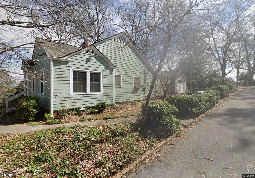
This home is located at 216 E 10th St SW, Rome, GA 30161 and is currently estimated at $252,411, approximately $145 per square foot. 216 E 10th St SW is a home located in Floyd County with nearby schools including Rome High School.
Ownership History
Date
Name
Owned For
Owner Type
Purchase Details
Closed on
Oct 19, 2015
Sold by
Beckman Brian
Bought by
Beckman Brian and Beckman Stephanie K
Current Estimated Value
Home Financials for this Owner
Home Financials are based on the most recent Mortgage that was taken out on this home.
Original Mortgage
$108,571
Outstanding Balance
$86,505
Interest Rate
4.5%
Mortgage Type
FHA
Estimated Equity
$165,906
Purchase Details
Closed on
Apr 11, 1975
Sold by
Hight Ii Gordon Lee and Sue Ellenberg
Bought by
Owen Wiley C
Purchase Details
Closed on
Jul 19, 1972
Sold by
Hand Elizabeth Joyner
Bought by
Hight Ii Gordon Lee and Sue Ellenberg
Purchase Details
Closed on
Mar 23, 1970
Sold by
Adams Ruth W
Bought by
Hand Elizabeth Joyner
Purchase Details
Closed on
Jan 1, 1901
Bought by
Adams Ruth W
Create a Home Valuation Report for This Property
The Home Valuation Report is an in-depth analysis detailing your home's value as well as a comparison with similar homes in the area
Home Values in the Area
Average Home Value in this Area
Purchase History
| Date | Buyer | Sale Price | Title Company |
|---|---|---|---|
| Beckman Brian | -- | -- | |
| Beckman Brian | $110,575 | -- | |
| Owen Wiley C | $35,000 | -- | |
| Hight Ii Gordon Lee | $25,000 | -- | |
| Hand Elizabeth Joyner | $18,000 | -- | |
| Adams Ruth W | -- | -- |
Source: Public Records
Mortgage History
| Date | Status | Borrower | Loan Amount |
|---|---|---|---|
| Open | Beckman Brian | $108,571 | |
| Closed | Beckman Brian | $108,571 |
Source: Public Records
Tax History
| Year | Tax Paid | Tax Assessment Tax Assessment Total Assessment is a certain percentage of the fair market value that is determined by local assessors to be the total taxable value of land and additions on the property. | Land | Improvement |
|---|---|---|---|---|
| 2025 | $2,396 | $99,375 | $13,065 | $86,310 |
| 2024 | $2,396 | $91,279 | $11,878 | $79,401 |
| 2023 | $2,381 | $86,603 | $10,666 | $75,937 |
| 2022 | $2,106 | $71,126 | $8,726 | $62,400 |
| 2021 | $2,021 | $64,383 | $8,726 | $55,657 |
| 2020 | $1,940 | $58,947 | $6,666 | $52,281 |
| 2019 | $1,864 | $55,572 | $6,666 | $48,906 |
| 2018 | $1,805 | $52,196 | $6,666 | $45,530 |
| 2017 | $1,758 | $49,482 | $6,666 | $42,816 |
| 2016 | $1,595 | $48,120 | $6,640 | $41,480 |
| 2015 | $893 | $49,308 | $6,640 | $42,668 |
| 2014 | $893 | $49,308 | $6,640 | $42,668 |
Source: Public Records
Map
Nearby Homes
- 31 Notasulga Dr SW
- 9 Eastridge Ct SW
- 419 E 13th St SW
- 803/805 Maple Ave SW
- 803/80 Maple Ave SW
- 170 E 11th St SW
- 162 E 11th St SE
- 168 E 11th St SE
- 164 E 11th St SE
- 166 E 11th St SW
- 1 E 11th St SW
- 209 Moultrie Ln SE
- 415 E 10th St SE
- 1011 Walnut Ave SW
- 416 E 9th St SE
- 801 Maple Ave SW
- 1312 E 2nd Ave SE
- 307 E 11th St SE
- 1314 E 2nd Ave SE
- 1407 E 2nd Ave SE
- 220 E 10th St SW
- 20 Notasulga Dr SW
- 222 E 10th St SW
- 18 Notasulga Dr SW
- 29 Notasulga Dr SW
- 11 Longbrooke Dr SE
- 2 Notasulga Dr SW
- 224 E 10th St SW
- 16 Notasulga Dr SW Unit A
- 16 Notasulga Dr SW Unit B
- 16 Notasulga Dr SW
- 217 E 10th St SW
- 27 Notasulga Dr SW
- 4 Notasulga Dr SW
- 14 Notasulga Dr SW
- 6 Notasulga Dr SW
- 25 Notasulga Dr SW
- 310 E 10th St SW
- 8 Notasulga Dr SW
- 219 E 10th St SW
Your Personal Tour Guide
Ask me questions while you tour the home.