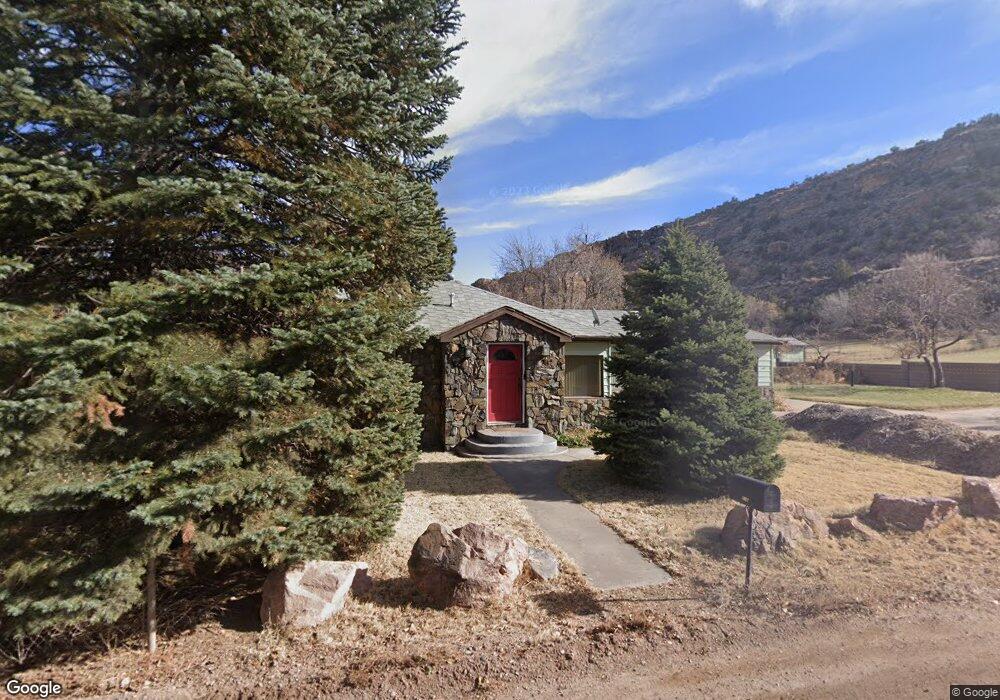
216 Grape St Cañon City, CO 81212
Estimated Value: $311,000 - $691,000
3
Beds
2
Baths
2,158
Sq Ft
$204/Sq Ft
Est. Value
About This Home
This home is located at 216 Grape St, Cañon City, CO 81212 and is currently estimated at $441,032, approximately $204 per square foot. 216 Grape St is a home located in Fremont County with nearby schools including Lincoln School of Science & Technology, Canon City Middle School, and Canon City High School.
Ownership History
Date
Name
Owned For
Owner Type
Purchase Details
Closed on
Jun 24, 2015
Sold by
Mcray Jerry Lee
Bought by
Rowland David B and Rowland Kristy L
Current Estimated Value
Home Financials for this Owner
Home Financials are based on the most recent Mortgage that was taken out on this home.
Original Mortgage
$159,500
Interest Rate
3.91%
Mortgage Type
Purchase Money Mortgage
Purchase Details
Closed on
Mar 14, 2012
Sold by
Mcray Roxanne Lee
Bought by
Mcray Jerry Lee
Purchase Details
Closed on
Mar 19, 2009
Sold by
Mcray Jerry Lee
Bought by
Mcray Jerry Lee and Mcray Roxanne Lee
Purchase Details
Closed on
Nov 13, 2000
Sold by
Suckle
Bought by
Mcray
Purchase Details
Closed on
Jan 31, 1997
Sold by
Carmack
Bought by
Suckle Suckle and Suckle Kralik
Create a Home Valuation Report for This Property
The Home Valuation Report is an in-depth analysis detailing your home's value as well as a comparison with similar homes in the area
Home Values in the Area
Average Home Value in this Area
Purchase History
| Date | Buyer | Sale Price | Title Company |
|---|---|---|---|
| Rowland David B | $259,500 | Fidelity National Title | |
| Mcray Jerry Lee | -- | None Available | |
| Mcray Jerry Lee | -- | Security Title | |
| Mcray | $175,000 | -- | |
| Suckle Suckle | -- | -- |
Source: Public Records
Mortgage History
| Date | Status | Borrower | Loan Amount |
|---|---|---|---|
| Closed | Rowland David B | $159,500 |
Source: Public Records
Tax History Compared to Growth
Tax History
| Year | Tax Paid | Tax Assessment Tax Assessment Total Assessment is a certain percentage of the fair market value that is determined by local assessors to be the total taxable value of land and additions on the property. | Land | Improvement |
|---|---|---|---|---|
| 2024 | $1,847 | $24,541 | $0 | $0 |
| 2023 | $1,847 | $20,856 | $0 | $0 |
| 2022 | $1,842 | $21,225 | $0 | $0 |
| 2021 | $1,847 | $21,836 | $0 | $0 |
| 2020 | $1,523 | $18,135 | $0 | $0 |
| 2019 | $1,504 | $18,135 | $0 | $0 |
| 2018 | $1,201 | $14,116 | $0 | $0 |
| 2017 | $1,118 | $14,116 | $0 | $0 |
| 2016 | $1,025 | $14,000 | $0 | $0 |
| 2015 | $1,023 | $14,000 | $0 | $0 |
| 2012 | $1,002 | $14,391 | $6,089 | $8,302 |
Source: Public Records
Map
Nearby Homes
- 123 W Catlin Ave
- 118 W Stanley Ave
- 104 Greenwood Ave
- 120 Greenwood Ave
- 205 Royal Gorge Blvd
- 205 Royal Gorge Blvd Unit 5-8
- 211 Greenwood Ave
- 212 Harrison Ave
- 1023 S 3rd St
- 323 N 4th St
- 414 Griffin Ave
- 3246 County Road 69
- 34 Wild Rose Dr
- 417 Greenwood Ave
- 46 Wild Rose Dr
- 315 N 5th St
- 412 Cooper Ave
- 523 N 5th St
- 950 Brewster Ave
- 215 Grape St
- 1211 Blake Dr
- 1208 Blake Dr
- 1202 Blake Dr
- 1032 Riverside Ave
- 920 Brewster Ave
- 1215 Blake Dr
- 1110 Riverside Ave
- 1003 Riverside Dr
- 1219 Blake Dr
- 1110 Riverside Dr Unit Lot 7
- 1221 Blake Dr
- 1210 Blake Dr
- 1231 Blake Dr
- 910 Riverside Dr
- 301 Grape Creek Dr
- 1235 Blake Dr
- 305 Grape Creek Dr
- 1233 Blake Dr