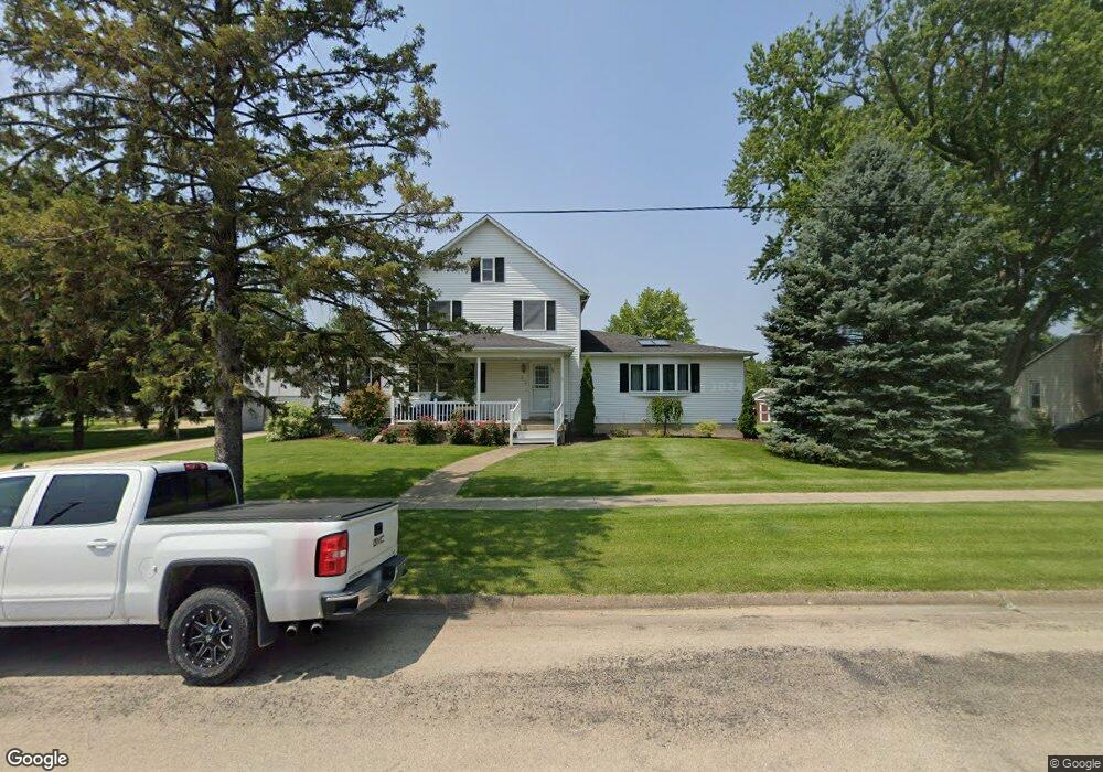
216 Main St Delmar, IA 52037
Estimated Value: $179,000 - $236,000
4
Beds
3
Baths
2,416
Sq Ft
$87/Sq Ft
Est. Value
About This Home
This home is located at 216 Main St, Delmar, IA 52037 and is currently estimated at $209,423, approximately $86 per square foot. 216 Main St is a home with nearby schools including Delwood Elementary School.
Ownership History
Date
Name
Owned For
Owner Type
Purchase Details
Closed on
Dec 6, 2021
Sold by
Deloris Newell Trust
Bought by
Bennis Kye Richard and Bennis Sara Lynn
Current Estimated Value
Home Financials for this Owner
Home Financials are based on the most recent Mortgage that was taken out on this home.
Original Mortgage
$1,080,310
Outstanding Balance
$1,024,627
Interest Rate
3.09%
Mortgage Type
New Conventional
Estimated Equity
-$815,204
Create a Home Valuation Report for This Property
The Home Valuation Report is an in-depth analysis detailing your home's value as well as a comparison with similar homes in the area
Purchase History
| Date | Buyer | Sale Price | Title Company |
|---|---|---|---|
| Bennis Kye Richard | $939,500 | Bartelt Glenn |
Source: Public Records
Mortgage History
| Date | Status | Borrower | Loan Amount |
|---|---|---|---|
| Open | Bennis Kye Richard | $1,080,310 | |
| Closed | Bennis Kye Richard | $1,029,323 |
Source: Public Records
Tax History
| Year | Tax Paid | Tax Assessment Tax Assessment Total Assessment is a certain percentage of the fair market value that is determined by local assessors to be the total taxable value of land and additions on the property. | Land | Improvement |
|---|---|---|---|---|
| 2025 | $3,270 | $185,500 | $19,320 | $166,180 |
| 2024 | $3,270 | $194,790 | $19,320 | $175,470 |
| 2023 | $3,224 | $194,790 | $19,320 | $175,470 |
| 2022 | $2,316 | $180,780 | $19,320 | $161,460 |
| 2021 | $1,860 | $126,860 | $19,870 | $106,990 |
| 2019 | $1,714 | $101,680 | $0 | $0 |
| 2018 | $1,678 | $101,680 | $0 | $0 |
| 2017 | $1,678 | $96,690 | $0 | $0 |
| 2016 | $1,606 | $96,690 | $0 | $0 |
| 2015 | $1,606 | $96,690 | $0 | $0 |
| 2014 | $1,458 | $96,690 | $0 | $0 |
| 2013 | $1,392 | $0 | $0 | $0 |
Source: Public Records
Map
Nearby Homes
- 213 Delmar Ave
- 105 Short St
- 0 200th Ave Unit MRDQC4268784
- 0 200th Ave Unit MRDQC4268785
- 0 200th Ave Unit MRDQC4268786
- Lot 2 Timber Dr
- Lot 3 Timber Dr
- Lot 1 Timber Dr
- 1374 290th Ave
- Lot 3 E Carlisle St
- 0 Nairn Dr Unit 153479
- 712 S 2nd St
- 314 E Locust St
- 260th Ave
- 302 E Maple St
- 701 W Summit St
- 313 S 4th St
- 407 W Maple St
- 1005 W Summit St
- 124 E Platt St
Your Personal Tour Guide
Ask me questions while you tour the home.