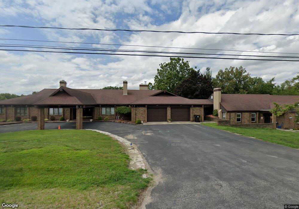
216 N Talbot St Addison, MI 49220
Estimated Value: $520,000 - $560,235
3
Beds
5
Baths
6,689
Sq Ft
$81/Sq Ft
Est. Value
About This Home
This home is located at 216 N Talbot St, Addison, MI 49220 and is currently estimated at $540,118, approximately $80 per square foot. 216 N Talbot St is a home located in Lenawee County with nearby schools including Addison Elementary School, Addison Middle School, and Addison High School.
Ownership History
Date
Name
Owned For
Owner Type
Purchase Details
Closed on
Apr 8, 2019
Sold by
Driver Richard A and Driver Brenda A
Bought by
Driver Richard A and Driver Brenda A
Current Estimated Value
Purchase Details
Closed on
May 15, 2017
Sold by
Hamlin Michelle L
Bought by
Driver Richard and Driver Brenda
Home Financials for this Owner
Home Financials are based on the most recent Mortgage that was taken out on this home.
Original Mortgage
$158,000
Interest Rate
3.34%
Mortgage Type
Closed End Mortgage
Purchase Details
Closed on
Oct 27, 2003
Bought by
Hamlin Lewis L and Michelle Lee
Create a Home Valuation Report for This Property
The Home Valuation Report is an in-depth analysis detailing your home's value as well as a comparison with similar homes in the area
Purchase History
| Date | Buyer | Sale Price | Title Company |
|---|---|---|---|
| Driver Richard A | -- | -- | |
| Driver Richard | -- | None Available | |
| Hamlin Lewis L | $200,000 | -- |
Source: Public Records
Mortgage History
| Date | Status | Borrower | Loan Amount |
|---|---|---|---|
| Previous Owner | Driver Richard | $158,000 |
Source: Public Records
Tax History
| Year | Tax Paid | Tax Assessment Tax Assessment Total Assessment is a certain percentage of the fair market value that is determined by local assessors to be the total taxable value of land and additions on the property. | Land | Improvement |
|---|---|---|---|---|
| 2025 | $2,841 | $325,100 | $0 | $0 |
| 2024 | $19 | $281,600 | $0 | $0 |
| 2023 | -- | $223,700 | $0 | $0 |
| 2022 | $2,600 | $224,400 | $0 | $0 |
| 2021 | $3,377 | $186,800 | $0 | $0 |
| 2020 | $3,303 | $85,000 | $0 | $0 |
| 2019 | $317,149 | $85,000 | $0 | $0 |
| 2018 | $3,818 | $229,984 | $0 | $0 |
| 2017 | $3,694 | $231,593 | $0 | $0 |
| 2016 | $5,097 | $227,327 | $0 | $0 |
| 2014 | -- | $328,731 | $0 | $0 |
Source: Public Records
Map
Nearby Homes
- 16001 Addison Rd
- 201 S Talbot St
- 6482 Sorby Hwy
- 18600 Manitou Rd
- 4955 N Somerset Rd
- 0
- VL Manitou Beach Road Proposed
- 0 Manitou Beach Rd Lot B
- 13840 N Adams Rd
- 13820 N Adams Rd
- 9265 Devils Lake Hwy
- 360 Park St
- 8676 Cherry Point Dr
- 348 Lenawee St
- 8164 Clarks Cove
- 7841 Devils Lake Hwy
- 17475 U S 223
- 12677 U S 223
- 6820 Devils Lake Hwy
- 10911 Devils Lake Hwy
- 216 N Talbot St
- 216 N Talbot St Unit 220 N. Talbot
- N Talbot Unit 220 N TALBOT
- 200 N Talbot St
- 220 N Talbot St
- 118 N Talbot St
- 106 N Talbot St
- 118 N Jackson St
- 106 E Main St
- 108 N Jackson St
- 114 N Talbot St
- 110 E Main St
- 120 E Main St
- 124 E Main St
- 0 W Main St Unit 4493070
- 0 W Main St Unit 4624611
- 0 W Main St Unit 20014622
- 0 W Main St Unit 20323810
- 0 W Main St Unit 20393235
- 0 W Main St Unit M21031270
Your Personal Tour Guide
Ask me questions while you tour the home.