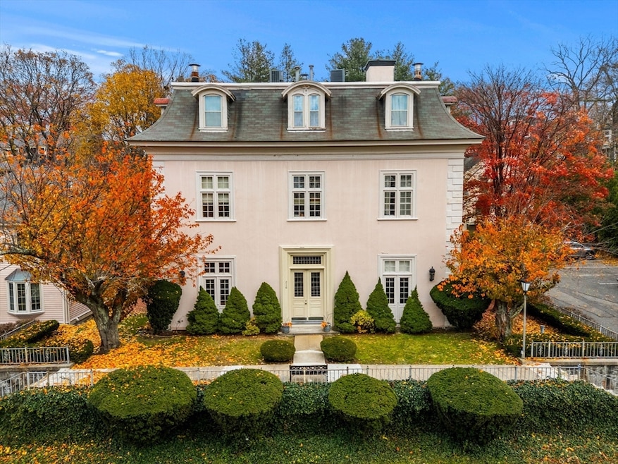
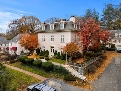
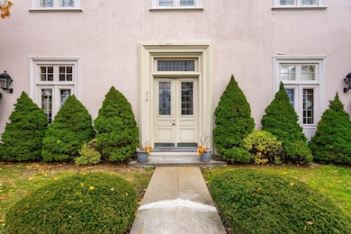
216 Nesmith St Unit 2 Lowell, MA 01852
Belvidere NeighborhoodEstimated payment $3,408/month
Highlights
- Popular Property
- City View
- Custom Closet System
- Medical Services
- Open Floorplan
- Property is near public transit
About This Home
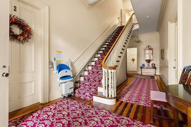
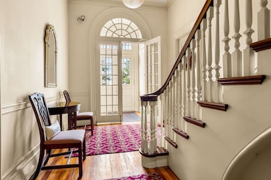
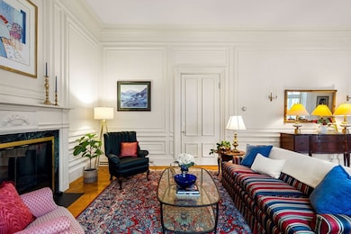
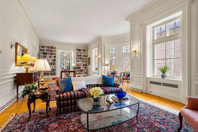
Step into timeless elegance at 216 Nesmith Street, where historic charm meets modern sophistication. This exquisite 2-bedroom, 2-bath condo, once part of a 19th-century chateau, radiates character and class. Enjoy rich hardwood floors, crown moldings, and custom millwork that showcase masterful craftsmanship. Step into the grandeur living room that features a stunning marble tiled fireplace, 12ft ceilings, built-in-bookshelves and large windows that flood the space with natural light. A full applianced kitchen with tiled flooring, recessed lighting, and generous cabinet space—perfect modern living needs. Two spacious bedrooms, two full baths, and in-unit laundry provide comfort and convenience. Ideally located near shopping, restaurants, highways, and entertainment. Whether you’re seeking a sophisticated retreat or a stylish place to reside, this rare condo offers unmatched class, craftsmanship, and comfort. Please allow 48 hour response for all offers.
Property Details
Home Type
- Condominium
Est. Annual Taxes
- $3,877
Year Built
- Built in 1985
Lot Details
- Garden
HOA Fees
- $450 Monthly HOA Fees
Parking
- 1 Car Garage
- Off-Street Parking
- Assigned Parking
Home Design
- Garden Home
- Entry on the 1st floor
Interior Spaces
- 1,540 Sq Ft Home
- 1-Story Property
- Open Floorplan
- Crown Molding
- French Doors
- Living Room with Fireplace
- City Views
- Basement
Kitchen
- Range
- Dishwasher
- Disposal
Flooring
- Wood
- Ceramic Tile
Bedrooms and Bathrooms
- 2 Bedrooms
- Custom Closet System
- Walk-In Closet
- 2 Full Bathrooms
Laundry
- Laundry in unit
- Dryer
- Washer
Outdoor Features
- Balcony
- Patio
Location
- Property is near public transit
- Property is near schools
Schools
- Central Enrollment Elementary And Middle School
- Lowell High School
Utilities
- Forced Air Heating and Cooling System
- 1 Cooling Zone
- Heating System Uses Natural Gas
Listing and Financial Details
- Assessor Parcel Number 3194763
Community Details
Overview
- Association fees include water, sewer, insurance, maintenance structure, road maintenance, ground maintenance, snow removal
- 12 Units
- Abbey Condominium Community
Amenities
- Medical Services
- Common Area
- Shops
Map
Home Values in the Area
Average Home Value in this Area
Tax History
| Year | Tax Paid | Tax Assessment Tax Assessment Total Assessment is a certain percentage of the fair market value that is determined by local assessors to be the total taxable value of land and additions on the property. | Land | Improvement |
|---|---|---|---|---|
| 2025 | $3,877 | $337,700 | $0 | $337,700 |
| 2024 | $3,652 | $306,600 | $0 | $306,600 |
| 2023 | $3,363 | $270,800 | $0 | $270,800 |
| 2022 | $3,194 | $251,700 | $0 | $251,700 |
| 2021 | $3,621 | $269,000 | $0 | $269,000 |
| 2020 | $3,480 | $260,500 | $0 | $260,500 |
| 2019 | $4,093 | $291,500 | $0 | $291,500 |
| 2018 | $4,118 | $286,200 | $0 | $286,200 |
| 2017 | $3,748 | $251,200 | $0 | $251,200 |
| 2016 | $3,694 | $243,700 | $0 | $243,700 |
| 2015 | $3,560 | $230,000 | $0 | $230,000 |
| 2013 | $3,634 | $242,100 | $0 | $242,100 |
Property History
| Date | Event | Price | List to Sale | Price per Sq Ft |
|---|---|---|---|---|
| 11/14/2025 11/14/25 | For Sale | $499,900 | -- | $325 / Sq Ft |
Purchase History
| Date | Type | Sale Price | Title Company |
|---|---|---|---|
| Deed | $135,000 | -- | |
| Deed | $177,250 | -- |
Mortgage History
| Date | Status | Loan Amount | Loan Type |
|---|---|---|---|
| Open | $108,000 | Purchase Money Mortgage | |
| Previous Owner | $133,000 | Purchase Money Mortgage |
Source: MLS Property Information Network (MLS PIN)
MLS Number: 73455190
APN: LOWE-000219-004280-000216-000002
Disclaimer: Certain information contained herein is derived from information provided by parties other than Homes.com. All information provided is deemed reliable, but is not guaranteed to be accurate and should be independently verified.
![]() The property listing data and information, or the Images, set forth herein were provided to MLS Property Information Network, Inc. from third party sources, including sellers, lessors and public records, and were compiled by MLS Property Information Network, Inc. The property listing data and information, and the Images, are for the personal, non-commercial use of consumers having a good faith interest in purchasing or leasing listed properties of the type displayed to them and may not be used for any purpose other than to identify prospective properties which such consumers may have a good faith interest in purchasing or leasing. MLS Property Information Network, Inc. and its subscribers disclaim any and all representations and warranties as to the accuracy of the property listing data and information, or as to the accuracy of any of the Images, set forth herein.
The property listing data and information, or the Images, set forth herein were provided to MLS Property Information Network, Inc. from third party sources, including sellers, lessors and public records, and were compiled by MLS Property Information Network, Inc. The property listing data and information, and the Images, are for the personal, non-commercial use of consumers having a good faith interest in purchasing or leasing listed properties of the type displayed to them and may not be used for any purpose other than to identify prospective properties which such consumers may have a good faith interest in purchasing or leasing. MLS Property Information Network, Inc. and its subscribers disclaim any and all representations and warranties as to the accuracy of the property listing data and information, or as to the accuracy of any of the Images, set forth herein.
- 53 Fairmount St
- 250 Nesmith St Unit 10
- 44 Hanks St
- 112 Fort Hill Ave
- 318 Andover St
- 355 Andover St
- 158 Concord St
- 162 Starr Ave
- 80 Rogers St Unit 204
- 80 Rogers St Unit 304
- 15 Alton St Unit 10
- 137 Hoyt Ave
- 260 Mansur St
- 96 Park Ave W Unit A4
- 540 Lawrence St
- 39 Groves Ave
- 9 Watson St
- 154 Parkview Ave
- 14 Watson St Unit 4
- 45 Luce St
- 66 Hanks St
- 66 Hanks St
- 505 High St Unit 505
- 213 Concord St Unit 1
- 466 E Merrimack St Unit 3
- 43 Nesmith St Unit 7
- 375 E Merrimack St Unit 1
- 170 Warren Ct Unit 1
- 168 Warren Ct Unit 1
- 333 First Street Blvd Unit 310
- 716 Lawrence St Unit 2
- 690 Lawrence St Unit 1
- 19 Elm St Unit 1
- 82 Luce St
- 122 Chapel St Unit 2
- 124 Chapel St Unit 3
- 449 Central St Unit 1
- 850 Lawrence St
- 19 Hurd St Unit 1
- 92 Gorham St Unit 201
