Estimated Value: $186,846 - $269,000
3
Beds
1
Bath
1,590
Sq Ft
$143/Sq Ft
Est. Value
About This Home
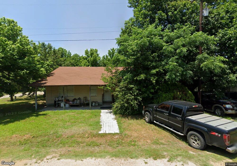
This home is located at 216 W Merritt Ave, Ennis, TX 75119 and is currently estimated at $227,923, approximately $143 per square foot. 216 W Merritt Ave is a home located in Ellis County with nearby schools including Austin Elementary School, Dorie Miller Int, and Ennis Junior High School.
Ownership History
Date
Name
Owned For
Owner Type
Purchase Details
Closed on
Jun 9, 2023
Sold by
Sheriff Ellis County
Bought by
Vien Ladd
Current Estimated Value
Purchase Details
Closed on
Apr 20, 2010
Sold by
Barajas Pablo and Barajas Celia
Bought by
Diaz Pedro Zepeda and Zepeda Margarita
Home Financials for this Owner
Home Financials are based on the most recent Mortgage that was taken out on this home.
Original Mortgage
$40,000
Interest Rate
4.91%
Create a Home Valuation Report for This Property
The Home Valuation Report is an in-depth analysis detailing your home's value as well as a comparison with similar homes in the area
Home Values in the Area
Average Home Value in this Area
Purchase History
| Date | Buyer | Sale Price | Title Company |
|---|---|---|---|
| Vien Ladd | $70,000 | None Listed On Document | |
| Diaz Pedro Zepeda | -- | -- |
Source: Public Records
Mortgage History
| Date | Status | Borrower | Loan Amount |
|---|---|---|---|
| Previous Owner | Diaz Pedro Zepeda | $40,000 |
Source: Public Records
Tax History Compared to Growth
Tax History
| Year | Tax Paid | Tax Assessment Tax Assessment Total Assessment is a certain percentage of the fair market value that is determined by local assessors to be the total taxable value of land and additions on the property. | Land | Improvement |
|---|---|---|---|---|
| 2025 | $2,391 | $146,666 | $55,000 | $91,666 |
| 2024 | $2,391 | $135,954 | $45,000 | $90,954 |
| 2023 | $2,391 | $217,051 | $45,000 | $172,051 |
| 2022 | $3,315 | $166,542 | $27,000 | $139,542 |
| 2021 | $3,045 | $140,430 | $15,000 | $125,430 |
| 2020 | $2,371 | $102,430 | $15,000 | $87,430 |
| 2019 | $1,621 | $67,240 | $0 | $0 |
| 2018 | $1,240 | $51,460 | $7,500 | $43,960 |
| 2017 | $1,293 | $52,710 | $7,500 | $45,210 |
| 2016 | $1,054 | $42,950 | $5,000 | $37,950 |
| 2015 | $1,004 | $40,900 | $5,000 | $35,900 |
| 2014 | $1,004 | $41,440 | $0 | $0 |
Source: Public Records
Map
Nearby Homes
- Lavon Plan at The Hollow
- Bowie Plan at The Hollow
- San Gabriel II Plan at The Hollow
- Cascade II Plan at The Hollow
- Bailey Plan at The Hollow
- Burnett Plan at The Hollow
- Briley Plan at The Hollow
- Basswood Plan at The Hollow
- 717 Woodcrest Dr
- 801 Woodcrest Dr
- 000 Sleepy Hollow Rd
- 2810 Belmont Dr
- 707 Oakmont Dr
- TBD Lot 6 Prachyl Rd
- 5530 Interstate 45
- 1002 Hoylake Ct
- 4740 Fm 879
- 2904 Terrytown Dr
- 2900 Terrytown Dr
- 2308 Louise Ln
- 214 W Merritt Ave
- 206 W Merritt Ave
- 102 N Templeton St
- 101 N Templeton St
- 211 W Merritt Ave
- 207 W Williams St
- 107 N Templeton St
- 205 W Merritt Ave
- 101 S Templeton St
- 103 N Ferris St
- 111 N Ferris St
- 200 N Templeton St
- 203 W Merritt Ave
- 306 W Merritt Ave
- 114 Garrett
- 000 Garrett
- 212 W Conner St
- 201 N Templeton St
- 206 W Williams St
- 300 W Conner St