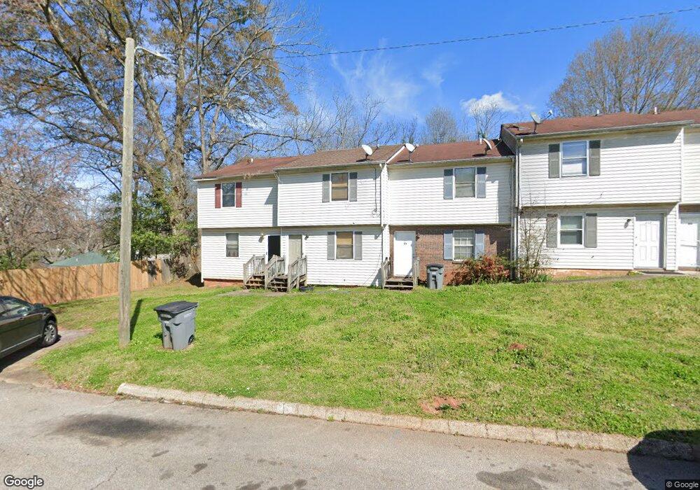
216 Wesley Way Lagrange, GA 30241
Estimated Value: $71,000 - $153,314
2
Beds
2
Baths
1,152
Sq Ft
$89/Sq Ft
Est. Value
About This Home
This home is located at 216 Wesley Way, Lagrange, GA 30241 and is currently estimated at $102,329, approximately $88 per square foot. 216 Wesley Way is a home located in Troup County with nearby schools including Hollis Hand Elementary School, Franklin Forest Elementary School, and Ethel W. Kight Elementary School.
Ownership History
Date
Name
Owned For
Owner Type
Purchase Details
Closed on
Mar 23, 2005
Sold by
Brown Thayer
Bought by
Brown Thayer and Brown Rita Davis
Current Estimated Value
Purchase Details
Closed on
Jun 1, 2004
Sold by
Fanning Linda Una
Bought by
Jp Morgan Chase Bank As Truste
Purchase Details
Closed on
Oct 4, 1997
Sold by
Cb
Bought by
Fanning Linda Una
Purchase Details
Closed on
Jun 11, 1997
Sold by
James R Aspinwall
Bought by
Cb
Purchase Details
Closed on
Oct 4, 1995
Sold by
Jerry Driver
Bought by
James R Aspinwall
Create a Home Valuation Report for This Property
The Home Valuation Report is an in-depth analysis detailing your home's value as well as a comparison with similar homes in the area
Home Values in the Area
Average Home Value in this Area
Purchase History
| Date | Buyer | Sale Price | Title Company |
|---|---|---|---|
| Brown Thayer | -- | -- | |
| Brown Thayer | $24,700 | -- | |
| Jp Morgan Chase Bank As Truste | $37,300 | -- | |
| Fanning Linda Una | -- | -- | |
| Cb | -- | -- | |
| James R Aspinwall | -- | -- |
Source: Public Records
Tax History Compared to Growth
Tax History
| Year | Tax Paid | Tax Assessment Tax Assessment Total Assessment is a certain percentage of the fair market value that is determined by local assessors to be the total taxable value of land and additions on the property. | Land | Improvement |
|---|---|---|---|---|
| 2024 | $688 | $25,240 | $1,840 | $23,400 |
| 2023 | $701 | $25,720 | $1,840 | $23,880 |
| 2022 | $669 | $23,960 | $1,840 | $22,120 |
| 2021 | $474 | $15,720 | $760 | $14,960 |
| 2020 | $474 | $15,720 | $760 | $14,960 |
| 2019 | $433 | $14,358 | $918 | $13,440 |
| 2018 | $433 | $14,358 | $918 | $13,440 |
| 2017 | $433 | $14,358 | $918 | $13,440 |
| 2016 | $420 | $13,910 | $918 | $12,992 |
| 2015 | $416 | $13,782 | $790 | $12,992 |
| 2014 | $430 | $14,204 | $790 | $13,415 |
| 2013 | -- | $14,204 | $790 | $13,415 |
Source: Public Records
Map
Nearby Homes
- 910 N 916 1000 1002 N Oak & 1011 1019 1021 Johnson St
- 0 Locust St
- 105 Dix St
- 803 1/2 Hines St
- 0 Burr St
- 306 Burr St
- 101 McGee St
- 801 Hines St
- 208 Render St
- 203 Revis St
- 205 Revis St
- 519 Greenville St
- LOT 58 Belk St
- 119 Belk St
- LOT 65 Belk St
- LOT 66 Belk St
- 203 Fannin St
- 205 Fannin St
- 200 Mccall St
- 117 Belk St
- 218 Wesley Way
- 214 Wesley Way
- 212 Wesley Way
- 210 Wesley Way
- 400 Ware St
- 314 Ware St
- 108 Wesley Way
- 204 Johnson St
- 0 Wesley Way Unit 7459235
- 0 Wesley Way Unit 7488372
- 0 Wesley Way Unit 7228589
- 0 Wesley Way Unit 7116869
- 0 Wesley Way Unit 7078986
- 0 Wesley Way
- 312 Ware St
- 106 Wesley Way
- 210 Johnson St
- 104 Wesley Way
- 404 Ware St
- 208 Johnson St