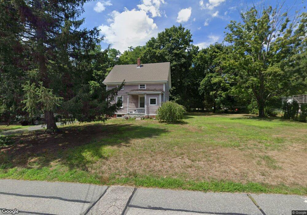
216 West Ave Seekonk, MA 02771
Estimated Value: $368,000 - $430,535
3
Beds
2
Baths
1,092
Sq Ft
$375/Sq Ft
Est. Value
About This Home
This home is located at 216 West Ave, Seekonk, MA 02771 and is currently estimated at $409,884, approximately $375 per square foot. 216 West Ave is a home located in Bristol County with nearby schools including Seekonk High School, St Margaret School, and The Wolf School.
Ownership History
Date
Name
Owned For
Owner Type
Purchase Details
Closed on
Feb 26, 1999
Sold by
Department Of Housing & Urban Dev
Bought by
Webb Angela S
Current Estimated Value
Home Financials for this Owner
Home Financials are based on the most recent Mortgage that was taken out on this home.
Original Mortgage
$110,000
Outstanding Balance
$26,690
Interest Rate
6.78%
Mortgage Type
Purchase Money Mortgage
Estimated Equity
$383,194
Purchase Details
Closed on
May 21, 1998
Sold by
Boyd Harry R and Chase Manhattan Mtg
Bought by
Chase Manhattan Mtg
Purchase Details
Closed on
May 1, 1996
Sold by
Ward William T and Ward Laura N
Bought by
Boyd Harry R and Boyd Kerry A
Home Financials for this Owner
Home Financials are based on the most recent Mortgage that was taken out on this home.
Original Mortgage
$124,387
Interest Rate
7.82%
Mortgage Type
Purchase Money Mortgage
Purchase Details
Closed on
Dec 27, 1989
Sold by
Beaty Daniel R
Bought by
Ward Wm T
Create a Home Valuation Report for This Property
The Home Valuation Report is an in-depth analysis detailing your home's value as well as a comparison with similar homes in the area
Home Values in the Area
Average Home Value in this Area
Purchase History
| Date | Buyer | Sale Price | Title Company |
|---|---|---|---|
| Webb Angela S | $104,000 | -- | |
| Chase Manhattan Mtg | $140,697 | -- | |
| Boyd Harry R | $125,000 | -- | |
| Ward Wm T | $136,000 | -- |
Source: Public Records
Mortgage History
| Date | Status | Borrower | Loan Amount |
|---|---|---|---|
| Open | Ward Wm T | $110,000 | |
| Previous Owner | Ward Wm T | $124,387 | |
| Previous Owner | Ward Wm T | $25,000 |
Source: Public Records
Tax History Compared to Growth
Tax History
| Year | Tax Paid | Tax Assessment Tax Assessment Total Assessment is a certain percentage of the fair market value that is determined by local assessors to be the total taxable value of land and additions on the property. | Land | Improvement |
|---|---|---|---|---|
| 2025 | $4,179 | $338,400 | $159,600 | $178,800 |
| 2024 | $4,025 | $325,900 | $159,600 | $166,300 |
| 2023 | $3,793 | $289,300 | $143,000 | $146,300 |
| 2022 | $3,500 | $262,400 | $137,300 | $125,100 |
| 2021 | $3,308 | $243,800 | $121,700 | $122,100 |
| 2020 | $3,105 | $235,800 | $121,600 | $114,200 |
| 2019 | $3,025 | $231,600 | $121,600 | $110,000 |
| 2018 | $2,914 | $218,300 | $121,600 | $96,700 |
| 2017 | $2,808 | $208,600 | $116,400 | $92,200 |
| 2016 | $2,804 | $209,100 | $116,400 | $92,700 |
| 2015 | $2,534 | $191,500 | $101,800 | $89,700 |
Source: Public Records
Map
Nearby Homes
- 243 West Ave
- 188 Newman Ave
- 282 West Ave
- 50 Dexter Ave
- 181 Sherman Ave
- 224 Arcade Ave
- 27 Gertrude Ave
- 24 Morra Way
- 60 West Dr
- 63 East Dr
- 25 East Dr
- 15 East Dr
- 136 Hoyt Ave
- 0 Newman Ave Rear
- 40 Upyonda Way
- 91 Seabiscuit Place
- 724 Beverage Hill Ave Unit 302
- 8 Pine Grove St
- 16 Elm Ave
- 0 Patterson St Unit 73348933