
Seller's Agent in 2025
Jane Chambers
Virginia Capital Realty
(804) 339-3969
3 in this area
85 Total Sales
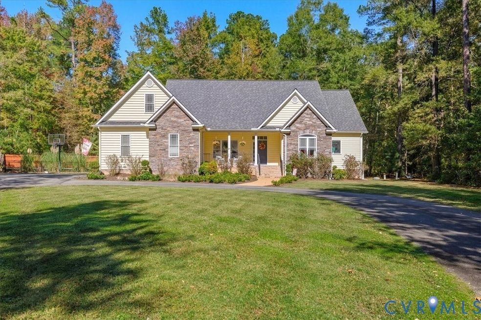


SHOWINGS BEGIN ON 10/18! Are you searching for a home with a little land, still tucked right here in Chesterfield County and within the Grange Hall, Deep Creek & Cosby school districts? Look no further because you’ve arrived! Welcome to 21600 Sappony Road, a charming ranch on nearly 3 acres. From the moment you pull up, the country porch is ready for rocking. Inside, you’ll find an office (or dining room, if that works better for you), and a spacious two-story family room anchored by a gorgeous stone fireplace offering cozy vibes. The kitchen, complete with a sunny eat-in area and tray ceiling, overlooks the beautifully landscaped backyard and sparkling pool (yes, we’ll get to that!). Hardwood floors flow throughout the foyer, hallway, dining room, and kitchen, tying the spaces together. The first-floor owner’s suite is a retreat all its own, with a tray ceiling with two walk-in closets, a double vanity, a jetted tub, and a separate shower. Den and primary bedroom have access your new favorite place to be ... the large screened porch which is ideal for morning coffee or chill-laxin with a view of the in-ground saltwater pool. Also you will find additional spacious bedrooms, another full bath, and a convenient utility room as you move throughout the rest of the home. Upstairs, a finished bonus room above the garage is the ultimate flex space whether you want a playroom, home office, workout room, or a chill spot to unwind, it’s ready for you. Just far enough from the hustle and bustle, this home delivers the peace of country living while keeping the convenience of the 360 corridor close by.
Last Agent to Sell the Property
Virginia Capital Realty License #0225212753 Listed on: 09/19/2025
Last Buyer's Agent
NON MLS USER MLS
NON MLS OFFICE
| Date | Type | Sale Price | Title Company |
|---|---|---|---|
| Gift Deed | -- | None Listed On Document | |
| Warranty Deed | $299,900 | -- |
| Date | Event | Price | List to Sale | Price per Sq Ft |
|---|---|---|---|---|
| 12/11/2025 12/11/25 | Sold | $590,000 | -1.5% | $259 / Sq Ft |
| 11/10/2025 11/10/25 | Pending | -- | -- | -- |
| 10/16/2025 10/16/25 | For Sale | $599,000 | -- | $263 / Sq Ft |
| Year | Tax Paid | Tax Assessment Tax Assessment Total Assessment is a certain percentage of the fair market value that is determined by local assessors to be the total taxable value of land and additions on the property. | Land | Improvement |
|---|---|---|---|---|
| 2025 | $3,988 | $445,300 | $79,800 | $365,500 |
| 2024 | $3,988 | $424,500 | $77,100 | $347,400 |
| 2023 | $3,440 | $378,000 | $72,600 | $305,400 |
| 2022 | $3,116 | $338,700 | $65,700 | $273,000 |
| 2021 | $3,170 | $326,700 | $63,900 | $262,800 |
| 2020 | $2,987 | $314,400 | $63,900 | $250,500 |
| 2019 | $2,882 | $303,400 | $62,100 | $241,300 |
| 2018 | $2,760 | $290,500 | $61,200 | $229,300 |
| 2017 | $2,700 | $281,200 | $60,300 | $220,900 |
| 2016 | $2,642 | $275,200 | $59,400 | $215,800 |
| 2015 | $2,553 | $263,300 | $59,400 | $203,900 |
| 2014 | $2,479 | $255,600 | $59,400 | $196,200 |
Seller's Agent in 2025
Jane Chambers
Virginia Capital Realty
(804) 339-3969
3 in this area
85 Total Sales
N
Buyer's Agent in 2025
NON MLS USER MLS
NON MLS OFFICE
Source: Central Virginia Regional MLS
MLS Number: 2526050
APN: 685-65-63-47-500-000
Disclaimer: Certain information contained herein is derived from information provided by parties other than Homes.com. All information provided is deemed reliable, but is not guaranteed to be accurate and should be independently verified.
![]() All or a portion of th multiple Listing information is provided by the Central Virginia Regional Multiple Listing Service, LLC, from a copyrighted compilation of Listing s. All CVR MLS information provided is deemed reliable but is not guaranteed accurate. The compilation of Listings and each individual Listing are ©2026 Central Virginia Regional Multiple Listing Service, LLC. All rights reserved.
All or a portion of th multiple Listing information is provided by the Central Virginia Regional Multiple Listing Service, LLC, from a copyrighted compilation of Listing s. All CVR MLS information provided is deemed reliable but is not guaranteed accurate. The compilation of Listings and each individual Listing are ©2026 Central Virginia Regional Multiple Listing Service, LLC. All rights reserved.
Ask me questions while you tour the home.