Estimated Value: $205,000 - $265,000
3
Beds
1
Bath
1,920
Sq Ft
$123/Sq Ft
Est. Value
About This Home
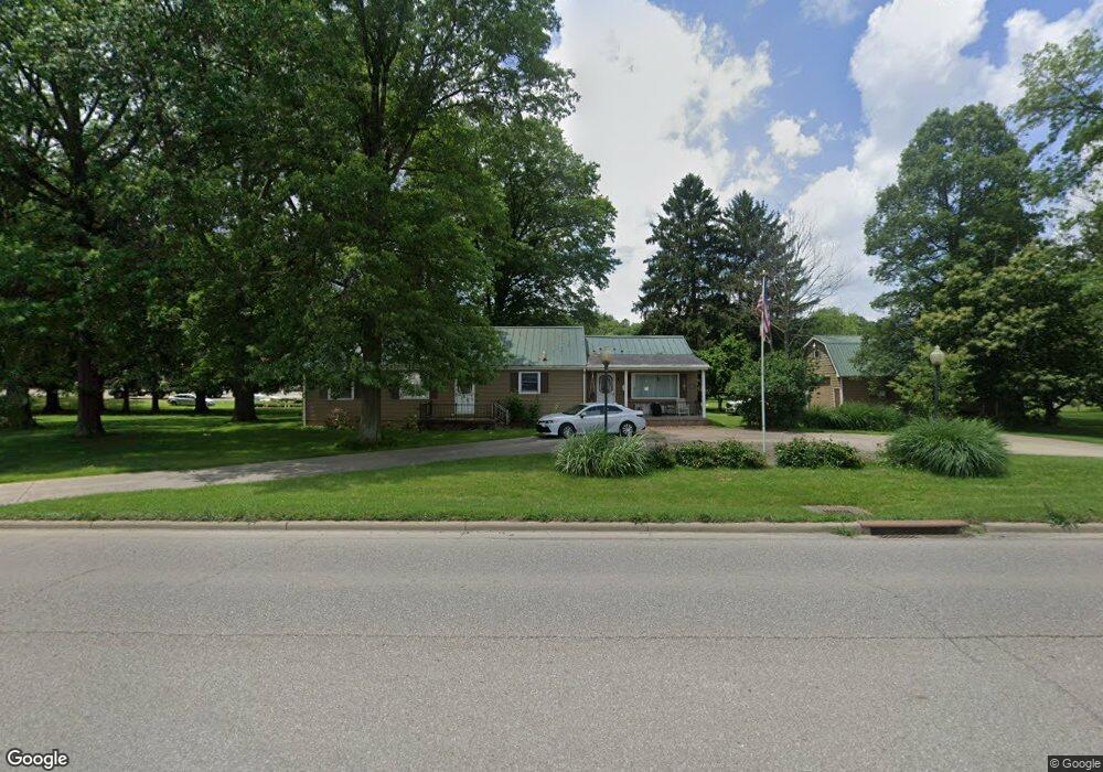
This home is located at 2161 State Route 39 NW, Dover, OH 44622 and is currently estimated at $235,698, approximately $122 per square foot. 2161 State Route 39 NW is a home located in Tuscarawas County with nearby schools including Dover High School, Tuscarawas Central Catholic Elementary School, and Tuscarawas Central Catholic Junior/Senior High School.
Ownership History
Date
Name
Owned For
Owner Type
Purchase Details
Closed on
Feb 16, 2016
Sold by
Tschantz Rudy J
Bought by
Tschantz Rudy J and Rudy J Tschantz Revocable Trust
Current Estimated Value
Purchase Details
Closed on
Jul 24, 2014
Sold by
Tschantz Ruth A and Tschantz Rudy J
Bought by
Tschantz Rudy J
Purchase Details
Closed on
Mar 11, 2013
Sold by
Tschantz Sam W and Tschantz Ruth A
Bought by
Tschantz Ruth A
Purchase Details
Closed on
Aug 3, 2012
Sold by
Tschantz Sam W and Tschantz Ruth A
Bought by
Tschantz Sam W and Tschantz Ruth A
Purchase Details
Closed on
Feb 6, 2007
Sold by
Tschantz Sam W and Tschantz Ruth A
Bought by
Tschantz Sam W and Tschantz Ruth A
Create a Home Valuation Report for This Property
The Home Valuation Report is an in-depth analysis detailing your home's value as well as a comparison with similar homes in the area
Home Values in the Area
Average Home Value in this Area
Purchase History
| Date | Buyer | Sale Price | Title Company |
|---|---|---|---|
| Tschantz Rudy J | -- | None Available | |
| Tschantz Rudy J | $88,090 | Alpha Land Title | |
| Tschantz Ruth A | -- | None Available | |
| Tschantz Sam W | -- | None Available | |
| Tschantz Sam W | -- | None Available |
Source: Public Records
Tax History Compared to Growth
Tax History
| Year | Tax Paid | Tax Assessment Tax Assessment Total Assessment is a certain percentage of the fair market value that is determined by local assessors to be the total taxable value of land and additions on the property. | Land | Improvement |
|---|---|---|---|---|
| 2024 | $1,981 | $47,600 | $13,000 | $34,600 |
| 2023 | $1,981 | $136,000 | $37,150 | $98,850 |
| 2022 | $2,003 | $47,600 | $13,003 | $34,598 |
| 2021 | $1,769 | $39,645 | $11,722 | $27,923 |
| 2020 | $1,769 | $39,645 | $11,722 | $27,923 |
| 2019 | $1,782 | $39,645 | $11,722 | $27,923 |
| 2018 | $1,793 | $37,900 | $11,210 | $26,690 |
| 2017 | $1,793 | $37,900 | $11,210 | $26,690 |
| 2016 | $1,796 | $37,900 | $11,210 | $26,690 |
| 2014 | $1,161 | $34,260 | $9,330 | $24,930 |
| 2013 | $1,164 | $34,260 | $9,330 | $24,930 |
Source: Public Records
Map
Nearby Homes
- 2180 Kimberley Dr NW
- 500 W 13th St
- 159 Charles Dr
- 1411 Chestnut St
- 1319 N Walnut St
- 3030 N Wooster Ave
- 0000 Red Hill Rd NW
- 227 E Slingluff Ave
- 306 E 15th St
- 0 Bair Rd NW Unit 5124469
- 0 Bair Rd NW Unit 5124477
- 0 Bair Rd NW Unit 5124464
- 0 Bair Rd NW Unit 5124485
- 0 Bair Rd NW Unit 5124339
- 0 Bair Rd NW Unit 5124397
- 0 Bair Rd NW Unit 5124402
- 0 Bair Rd NW Unit 5124415
- 0 Bair Rd NW Unit 5124421
- 450 E 5th St
- 442 E 4th St
- 2170 State Route 39 NW
- 2150 Ohio 39
- 2184 State Route 39 NW
- 2391 Circleview Dr NW
- 2213 State Route 39 NW
- 2120 Ohio 39
- 2226 Donald St
- 2198 Donald St
- 3361 Circleview Dr NW
- 3326 Circleview Dr NW
- 2135 State Route 39 NW
- 2158 Donald St
- 2117 State Route 39 NW
- 3183 Reese Rd NW
- 2024 State Route 39 NW
- 2563 Circleview Dr NW
- 3272 Circleview Dr NW
- 2605 Circleview Dr NW
- 2174 State Route 516 NW
- 0 Ohio 516 Unit 4473365