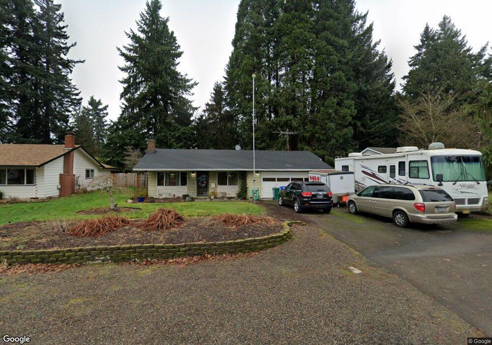
21633 SE Oak St Gresham, OR 97030
North Central NeighborhoodEstimated Value: $420,000 - $485,000
3
Beds
2
Baths
1,408
Sq Ft
$324/Sq Ft
Est. Value
About This Home
This home is located at 21633 SE Oak St, Gresham, OR 97030 and is currently estimated at $456,059, approximately $323 per square foot. 21633 SE Oak St is a home located in Multnomah County with nearby schools including North Gresham Elementary School, Clear Creek Middle School, and Gresham High School.
Ownership History
Date
Name
Owned For
Owner Type
Purchase Details
Closed on
May 17, 2024
Sold by
Bliss Sandra Ann
Bought by
Lefave Paula
Current Estimated Value
Purchase Details
Closed on
Mar 31, 2021
Sold by
Bliss Sanora Ann
Bought by
Bliss Sandra Ann and Le Fave Paula
Create a Home Valuation Report for This Property
The Home Valuation Report is an in-depth analysis detailing your home's value as well as a comparison with similar homes in the area
Home Values in the Area
Average Home Value in this Area
Purchase History
| Date | Buyer | Sale Price | Title Company |
|---|---|---|---|
| Lefave Paula | -- | None Listed On Document | |
| Bliss Sandra Ann | $158,000 | None Available |
Source: Public Records
Tax History
| Year | Tax Paid | Tax Assessment Tax Assessment Total Assessment is a certain percentage of the fair market value that is determined by local assessors to be the total taxable value of land and additions on the property. | Land | Improvement |
|---|---|---|---|---|
| 2025 | $4,297 | $211,150 | -- | -- |
| 2024 | $4,113 | $205,000 | -- | -- |
| 2023 | $3,747 | $199,030 | $0 | $0 |
| 2022 | $3,643 | $193,240 | $0 | $0 |
| 2021 | $3,551 | $187,620 | $0 | $0 |
| 2020 | $3,341 | $182,160 | $0 | $0 |
| 2019 | $3,254 | $176,860 | $0 | $0 |
| 2018 | $3,102 | $171,710 | $0 | $0 |
| 2017 | $2,977 | $166,710 | $0 | $0 |
| 2016 | $2,624 | $161,860 | $0 | $0 |
| 2015 | $2,568 | $157,150 | $0 | $0 |
| 2014 | $2,505 | $152,580 | $0 | $0 |
Source: Public Records
Map
Nearby Homes
- 21525 SE Oak St
- 132 SE 214th Ave
- 209 SE 214th Ave
- 21400 SE Stark St Unit 2
- 920 SE 214th Ave
- 21016 SE Stark St Unit 69
- 21001 SE Yamhill St
- 1026 SE 209th Ave
- 1035 SE 225th Ave
- 2730 NE Roberts Ave
- 1208 SE 209th Ave
- 872 NE Pacific Dr
- 760 NE Pacific Dr
- 85 NE 23rd St
- 22285 NE Park Ln
- 2013 NW Bella Vista Dr
- 1305 NE Village St
- 1711 NW 19th St
- 2775 NE Linden Ave
- 1505 NE Village St
- 21617 SE Oak St
- 21657 SE Oak St
- 21636 SE Ash St
- 21605 SE Oak St
- 21650 SE Ash St
- 21701 SE Oak St
- 21713 SE Oak St
- 21646 SE Oak St
- 21620 SE Ash St
- 21622 SE Oak St
- 21658 SE Oak St
- 21712 SE Ash St
- 21704 SE Oak St
- 21610 SE Oak St
- 21545 SE Oak St
- 21727 SE Oak St
- 21712 SE Oak St
- 21726 SE Ash St
- 21552 SE Ash St
- 21730 SE Ash St
Your Personal Tour Guide
Ask me questions while you tour the home.