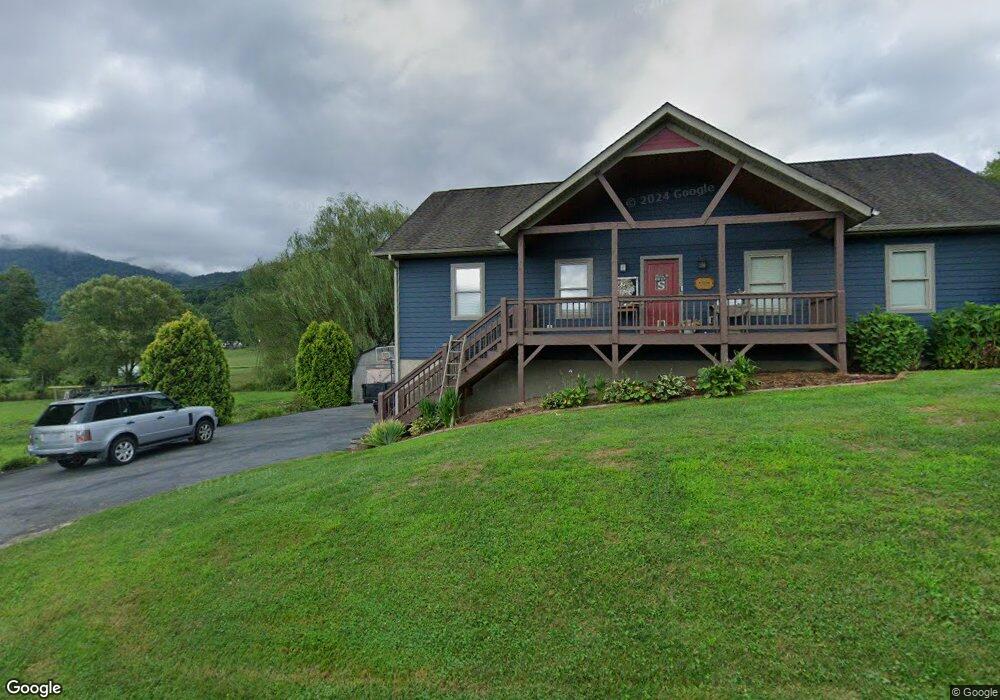
2164 Murray Rd Canton, NC 28716
Estimated Value: $346,000 - $539,000
3
Beds
2
Baths
1,590
Sq Ft
$286/Sq Ft
Est. Value
About This Home
This home is located at 2164 Murray Rd, Canton, NC 28716 and is currently estimated at $454,139, approximately $285 per square foot. 2164 Murray Rd is a home located in Haywood County with nearby schools including Bethel Elementary, Bethel Middle School, and Pisgah High School.
Ownership History
Date
Name
Owned For
Owner Type
Purchase Details
Closed on
Apr 21, 2009
Sold by
Moody Evelyn
Bought by
Smathers Donovan Matthew
Current Estimated Value
Purchase Details
Closed on
Dec 20, 2007
Sold by
Phillips Christopher D and Phillips Mandy
Bought by
Smathers Donovan and Smathers Kendra
Home Financials for this Owner
Home Financials are based on the most recent Mortgage that was taken out on this home.
Original Mortgage
$217,600
Interest Rate
6.21%
Mortgage Type
New Conventional
Purchase Details
Closed on
Aug 10, 2007
Sold by
Jcw Land Development Ltd
Bought by
Phillips Christopher D and Phillips Mandy
Home Financials for this Owner
Home Financials are based on the most recent Mortgage that was taken out on this home.
Original Mortgage
$237,500
Interest Rate
6.37%
Mortgage Type
New Conventional
Purchase Details
Closed on
Jan 20, 2006
Sold by
Caldwell Jason B and Caldwell Marissa R
Bought by
Jcw Land Development Ltd
Create a Home Valuation Report for This Property
The Home Valuation Report is an in-depth analysis detailing your home's value as well as a comparison with similar homes in the area
Home Values in the Area
Average Home Value in this Area
Purchase History
| Date | Buyer | Sale Price | Title Company |
|---|---|---|---|
| Smathers Donovan Matthew | -- | None Available | |
| Smathers Donovan | $272,000 | None Available | |
| Phillips Christopher D | $250,000 | None Available | |
| Jcw Land Development Ltd | $30,000 | None Available |
Source: Public Records
Mortgage History
| Date | Status | Borrower | Loan Amount |
|---|---|---|---|
| Previous Owner | Smathers Donovan | $217,600 | |
| Previous Owner | Phillips Christopher D | $237,500 |
Source: Public Records
Tax History
| Year | Tax Paid | Tax Assessment Tax Assessment Total Assessment is a certain percentage of the fair market value that is determined by local assessors to be the total taxable value of land and additions on the property. | Land | Improvement |
|---|---|---|---|---|
| 2025 | -- | $274,500 | $34,000 | $240,500 |
| 2024 | $19 | $274,500 | $34,000 | $240,500 |
| 2023 | $1,861 | $274,500 | $34,000 | $240,500 |
| 2022 | $1,861 | $274,500 | $34,000 | $240,500 |
| 2021 | $1,861 | $274,500 | $34,000 | $240,500 |
| 2020 | $1,679 | $226,800 | $34,000 | $192,800 |
| 2019 | $1,684 | $226,800 | $34,000 | $192,800 |
| 2018 | $1,684 | $226,800 | $34,000 | $192,800 |
| 2017 | $1,661 | $226,800 | $0 | $0 |
| 2016 | $1,753 | $247,900 | $0 | $0 |
| 2015 | $1,753 | $247,900 | $0 | $0 |
| 2014 | $1,620 | $247,900 | $0 | $0 |
Source: Public Records
Map
Nearby Homes
- 1901 Murray Rd
- 4 Mayapple Ln
- 706 Ramble Ln
- 32 Windy Hill Ln
- 133 Windy Hill Ln
- 800 Murray Rd
- 600 Scottdale Rd
- 57 Eden Brook Dr
- 201 Mountain Vista Rd
- 00 Aquarius Rd
- 999 Wilson Dr
- 99 Thistle Ridge
- 3760 Pisgah Dr
- 8573 Cruso Rd
- 57 Bittersweet Trail
- 27 Barkn Cove
- 1001 Mountain Glen Rd
- 36 Lambert Ln
- 131 Tobacco Trail
- 248 Max Thompson Rd
- 2108 Murray Rd
- 2123 Murray Rd
- 2206 Murray Rd
- 2104 Murray Rd
- 2183 Murray Rd
- 2224 Murray Rd
- 2079 Murray Rd
- 2078 Murray Rd
- 82 Wilson Branch Rd
- 21 Wilson Branch Rd
- 1561 Henson Cove Rd
- 1561 Henson Cove Rd
- 2258 Old Henson Cove Rd
- 194 Wilson Branch Rd
- 1452 Henson Cove Rd
- 2322 Old Henson Cove Rd
- 53 Wilson Branch Rd
- 193 Wilson Branch Rd
- 1957 Murray Rd
- 54 Creekside Ln
Your Personal Tour Guide
Ask me questions while you tour the home.