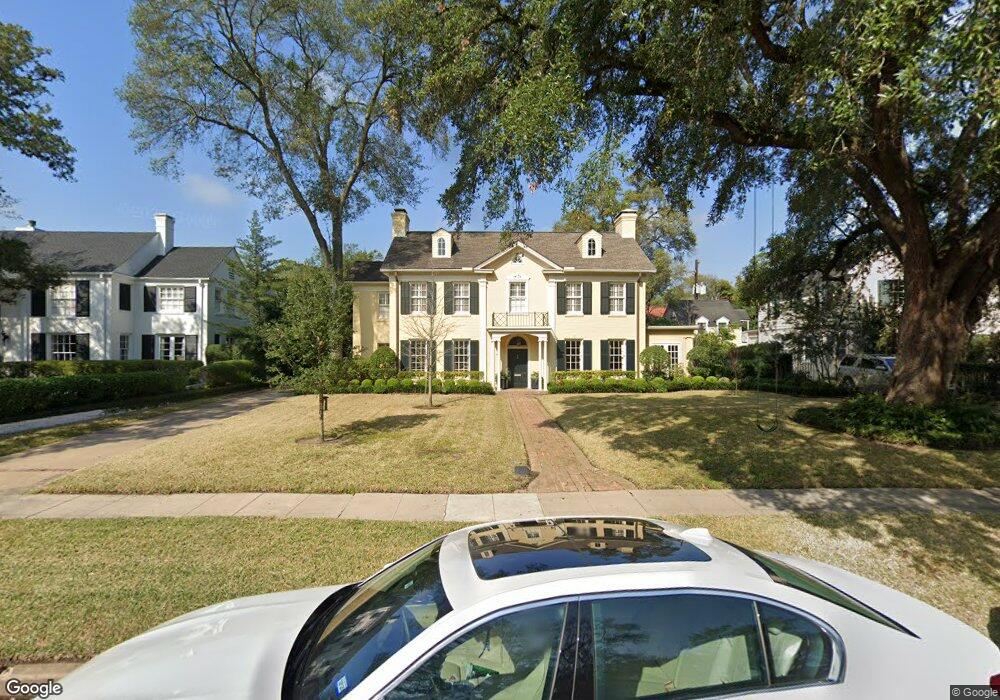
2164 Troon Rd Houston, TX 77019
River Oaks NeighborhoodEstimated Value: $3,027,000 - $3,343,000
6
Beds
5
Baths
4,791
Sq Ft
$668/Sq Ft
Est. Value
About This Home
This home is located at 2164 Troon Rd, Houston, TX 77019 and is currently estimated at $3,198,616, approximately $667 per square foot. 2164 Troon Rd is a home located in Harris County with nearby schools including River Oaks Elementary School, Lanier Middle School, and Lamar High School.
Ownership History
Date
Name
Owned For
Owner Type
Purchase Details
Closed on
May 1, 1997
Sold by
Burge William F and Burge Pamela Sue
Bought by
Romano Joseph J and Romano Anne
Current Estimated Value
Purchase Details
Closed on
Mar 7, 1996
Sold by
Burge William F
Bought by
Burge Pamela Sue
Create a Home Valuation Report for This Property
The Home Valuation Report is an in-depth analysis detailing your home's value as well as a comparison with similar homes in the area
Home Values in the Area
Average Home Value in this Area
Purchase History
| Date | Buyer | Sale Price | Title Company |
|---|---|---|---|
| Romano Joseph J | -- | Lawyers Title Company | |
| Burge Pamela Sue | -- | Lawyers Title Company |
Source: Public Records
Tax History Compared to Growth
Tax History
| Year | Tax Paid | Tax Assessment Tax Assessment Total Assessment is a certain percentage of the fair market value that is determined by local assessors to be the total taxable value of land and additions on the property. | Land | Improvement |
|---|---|---|---|---|
| 2025 | $34,831 | $3,027,400 | $2,190,150 | $837,250 |
| 2024 | $34,831 | $2,474,377 | $2,048,850 | $425,527 |
| 2023 | $33,530 | $2,487,945 | $1,978,200 | $509,745 |
| 2022 | $35,893 | $2,225,261 | $1,836,900 | $388,361 |
| 2021 | $54,965 | $2,290,798 | $1,766,250 | $524,548 |
| 2020 | $55,212 | $2,280,000 | $1,766,250 | $513,750 |
| 2019 | $55,405 | $2,189,527 | $1,766,250 | $423,277 |
| 2018 | $40,981 | $2,263,100 | $1,836,900 | $426,200 |
| 2017 | $46,646 | $2,397,300 | $1,836,900 | $560,400 |
| 2016 | $42,406 | $2,318,000 | $1,766,250 | $551,750 |
| 2015 | $28,472 | $2,055,339 | $1,437,150 | $618,189 |
| 2014 | $28,472 | $1,521,000 | $1,306,500 | $214,500 |
Source: Public Records
Map
Nearby Homes
- 2117 Chilton Rd
- 2116 Looscan Ln
- 1216 S Shepherd Dr
- 2247 Chilton Rd
- 20 Tiel Way
- 1025 S Shepherd Dr Unit 209
- 1005 S Shepherd Dr Unit 406
- 1005 S Shepherd Dr Unit 304
- 2131 Brentwood Dr
- 1201 Mcduffie St Unit 198
- 2204 Inwood Dr
- 102 Asbury St Unit 2803
- 102 Asbury St Unit 1704
- 102 Asbury St Unit 2202
- 102 Asbury St Unit 3703
- 102 Asbury St Unit 1003
- 102 Asbury St Unit 1901
- 102 Asbury St Unit 3501
- 2413 Brentwood Dr
- 5248 Memorial Dr Unit 5248