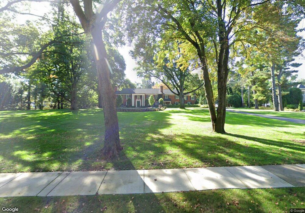
2169 Tottenham Rd Bloomfield Hills, MI 48301
Estimated Value: $3,222,000 - $5,145,000
6
Beds
8
Baths
7,207
Sq Ft
$577/Sq Ft
Est. Value
About This Home
This home is located at 2169 Tottenham Rd, Bloomfield Hills, MI 48301 and is currently estimated at $4,156,750, approximately $576 per square foot. 2169 Tottenham Rd is a home located in Oakland County with nearby schools including Quarton Elementary, Derby Middle School, and Ernest W. Seaholm High School.
Ownership History
Date
Name
Owned For
Owner Type
Purchase Details
Closed on
Feb 27, 2018
Sold by
Mullany Joseph J and Mullany Cori
Bought by
Aaron Jonathon and Aaron Mary
Current Estimated Value
Purchase Details
Closed on
Aug 23, 2012
Sold by
Skandalaris Robert and Skandalaris Julie A
Bought by
Mullany Joseph J and Mullany Cori
Create a Home Valuation Report for This Property
The Home Valuation Report is an in-depth analysis detailing your home's value as well as a comparison with similar homes in the area
Home Values in the Area
Average Home Value in this Area
Purchase History
| Date | Buyer | Sale Price | Title Company |
|---|---|---|---|
| Aaron Jonathon | $3,645,000 | None Available | |
| Mullany Joseph J | -- | Devon Title Agency |
Source: Public Records
Tax History
| Year | Tax Paid | Tax Assessment Tax Assessment Total Assessment is a certain percentage of the fair market value that is determined by local assessors to be the total taxable value of land and additions on the property. | Land | Improvement |
|---|---|---|---|---|
| 2025 | $72,392 | $2,114,220 | $706,280 | $1,407,940 |
| 2024 | $38,651 | $2,114,220 | $0 | $0 |
| 2023 | $37,093 | $1,901,490 | $0 | $0 |
| 2022 | $64,171 | $1,800,900 | $0 | $0 |
| 2021 | $64,703 | $1,700,010 | $0 | $0 |
| 2020 | $34,960 | $1,617,540 | $0 | $0 |
| 2019 | $64,504 | $1,549,850 | $0 | $0 |
| 2018 | $57,686 | $1,449,340 | $0 | $0 |
| 2017 | $57,143 | $1,405,000 | $0 | $0 |
| 2016 | $57,468 | $1,451,370 | $0 | $0 |
| 2015 | -- | $1,404,840 | $0 | $0 |
| 2014 | -- | $1,291,950 | $0 | $0 |
| 2011 | -- | $1,068,530 | $0 | $0 |
Source: Public Records
Map
Nearby Homes
- 1120 Lyonhurst St
- 60 Quarton Ln
- 1444 Fairfax St
- 1882 Melbourne St
- 1094 Suffield Ave
- 375 Dunston Rd
- 1183 Puritan Ave
- 341 Lowell Ct
- 1309 Sandringham Way
- 1295 Lakeside Dr
- 1551 Lakeside Dr
- 363 Lakewood Dr
- 591 Rudgate Rd
- 592 Lakeside Dr
- 1115 N Old Woodward Ave Unit 52
- 1115 N Old Woodward Ave Unit 61
- 394 S Glenhurst Dr
- 596 Rudgate Rd
- 1115 N Old Woodward #76 Ave
- 3249 Bradway Blvd
- 1331 Westwood Dr
- 1241 Westwood Dr
- 2215 Tottenham Rd
- 1369 Westwood Dr
- 1185 Westwood Dr
- 2140 Yarmouth Rd
- 1298 Westwood Dr
- 2243 Tottenham Rd Unit Bldg-Unit
- 2243 Tottenham Rd
- 2200 Tottenham Rd
- 1274 Westwood Dr
- 1356 Westwood Dr
- 2168 Yarmouth Rd
- 1133 Westwood Dr
- 1186 Westwood Dr Unit Bldg-Unit
- 1186 Westwood Dr
- 2152 Tottenham Rd
- 1394 Westwood Dr
- 1150 Westwood Dr
- 2192 Yarmouth Rd
Your Personal Tour Guide
Ask me questions while you tour the home.