Estimated Value: $155,000 - $206,000
3
Beds
2
Baths
1,232
Sq Ft
$147/Sq Ft
Est. Value
About This Home
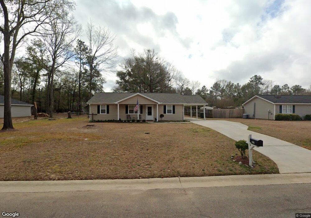
This home is located at 217 Addison Ln, Perry, GA 31069 and is currently estimated at $181,370, approximately $147 per square foot. 217 Addison Ln is a home located in Houston County with nearby schools including Langston Road Elementary School, Mossy Creek Middle School, and Perry High School.
Ownership History
Date
Name
Owned For
Owner Type
Purchase Details
Closed on
Jun 3, 2005
Sold by
Boselie Marinus M and Boselie Susan J
Bought by
Washington Christine
Current Estimated Value
Home Financials for this Owner
Home Financials are based on the most recent Mortgage that was taken out on this home.
Original Mortgage
$89,000
Outstanding Balance
$52,653
Interest Rate
5.74%
Mortgage Type
Purchase Money Mortgage
Estimated Equity
$128,717
Purchase Details
Closed on
Mar 15, 2002
Sold by
Maund Robert W
Bought by
Boselie Marinus M and Boselie Susan J
Purchase Details
Closed on
Apr 30, 1999
Sold by
Halstead Ii Randolph R and Halstead Kimberly S
Bought by
Maund Robert W
Purchase Details
Closed on
Jul 24, 1996
Sold by
La Development Inc
Bought by
Halstead Ii Randolph F and Halstead Kimberly S
Create a Home Valuation Report for This Property
The Home Valuation Report is an in-depth analysis detailing your home's value as well as a comparison with similar homes in the area
Home Values in the Area
Average Home Value in this Area
Purchase History
| Date | Buyer | Sale Price | Title Company |
|---|---|---|---|
| Washington Christine | $89,000 | None Available | |
| Boselie Marinus M | $73,000 | -- | |
| Maund Robert W | $69,000 | -- | |
| Halstead Ii Randolph F | $64,900 | -- |
Source: Public Records
Mortgage History
| Date | Status | Borrower | Loan Amount |
|---|---|---|---|
| Open | Washington Christine | $89,000 |
Source: Public Records
Tax History
| Year | Tax Paid | Tax Assessment Tax Assessment Total Assessment is a certain percentage of the fair market value that is determined by local assessors to be the total taxable value of land and additions on the property. | Land | Improvement |
|---|---|---|---|---|
| 2025 | $910 | $53,280 | $6,000 | $47,280 |
| 2024 | $925 | $47,760 | $6,000 | $41,760 |
| 2023 | $745 | $39,920 | $6,000 | $33,920 |
| 2022 | $733 | $39,400 | $6,000 | $33,400 |
| 2021 | $601 | $33,840 | $6,000 | $27,840 |
| 2020 | $506 | $29,800 | $4,400 | $25,400 |
| 2019 | $506 | $29,800 | $4,320 | $25,480 |
| 2018 | $506 | $29,800 | $4,320 | $25,480 |
| 2017 | $506 | $29,800 | $4,320 | $25,480 |
| 2016 | $481 | $28,760 | $4,320 | $24,440 |
| 2015 | $481 | $28,760 | $4,320 | $24,440 |
| 2014 | -- | $28,760 | $4,320 | $24,440 |
| 2013 | -- | $31,640 | $7,200 | $24,440 |
Source: Public Records
Map
Nearby Homes
- 602 Wooden Eagle Trail
- 505 Wooden Eagle Trail
- 305 Gibson Cir
- 304 N Lake Dr
- 109 Village Blvd
- 103 Wooden Eagle Trail
- 201 Boulder Creek Rd
- 203 Saraland Trail
- 103 Anna Claire Way
- 115 Mallards Landing Dr
- 115 Woody Dr
- 107 Waldorf Dr
- 219 Otters Ridge Dr
- 105 Gallberry Ln Unit 49G
- 107 Gallberry Ln Unit 50G
- 107 Gallberry Ln
- 103 Gallberry Ln
- 103 Gallberry Ln Unit 48G
- 212 Bald Cypress Dr Unit 46G
- 212 Bald Cypress Dr
- 215 Addison Ln
- 219 Addison Ln
- 407 Cavalcade Ct
- 213 Addison Ln
- 216 Addison Ln
- 218 Addison Ln
- 214 Addison Ln
- 206 Sunnybrook Dr
- 220 Addison Ln
- 212 Addison Ln
- 204 Sunnybrook Dr
- 223 Addison Ln
- 405 Cavalcade Ct
- 408 Cavalcade Ct
- 213 Annas Way
- 210 Addison Ln
- 211 Annas Way
- 215 Annas Way
- 215 Annas Way Unit 23
- 215 Anna's Way
Your Personal Tour Guide
Ask me questions while you tour the home.