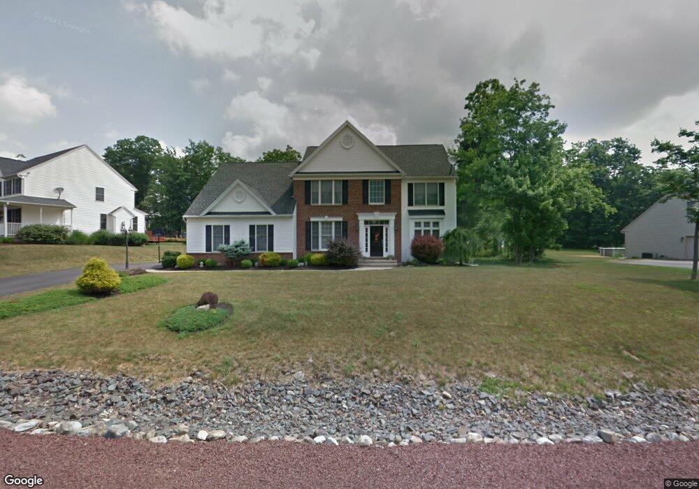
217 Bluestone Ave Mountain Top, PA 18707
Estimated Value: $537,000 - $721,000
4
Beds
3
Baths
2,950
Sq Ft
$204/Sq Ft
Est. Value
About This Home
This home is located at 217 Bluestone Ave, Mountain Top, PA 18707 and is currently estimated at $602,852, approximately $204 per square foot. 217 Bluestone Ave is a home located in Luzerne County with nearby schools including Crestwood Secondary Campus (Crestwood High School) and St Jude School.
Ownership History
Date
Name
Owned For
Owner Type
Purchase Details
Closed on
Jul 1, 2013
Sold by
Cordeiro Manuel and Nogueira Anabela
Bought by
Brady Edward L and Brady Michelle M
Current Estimated Value
Home Financials for this Owner
Home Financials are based on the most recent Mortgage that was taken out on this home.
Original Mortgage
$364,800
Outstanding Balance
$255,301
Interest Rate
3.51%
Mortgage Type
New Conventional
Estimated Equity
$347,552
Create a Home Valuation Report for This Property
The Home Valuation Report is an in-depth analysis detailing your home's value as well as a comparison with similar homes in the area
Home Values in the Area
Average Home Value in this Area
Purchase History
| Date | Buyer | Sale Price | Title Company |
|---|---|---|---|
| Brady Edward L | $384,000 | None Available |
Source: Public Records
Mortgage History
| Date | Status | Borrower | Loan Amount |
|---|---|---|---|
| Open | Brady Edward L | $364,800 |
Source: Public Records
Tax History
| Year | Tax Paid | Tax Assessment Tax Assessment Total Assessment is a certain percentage of the fair market value that is determined by local assessors to be the total taxable value of land and additions on the property. | Land | Improvement |
|---|---|---|---|---|
| 2026 | $8,252 | $388,900 | $71,100 | $317,800 |
| 2025 | $8,106 | $388,900 | $71,100 | $317,800 |
| 2024 | $7,971 | $388,900 | $71,100 | $317,800 |
| 2023 | $7,721 | $388,900 | $71,100 | $317,800 |
| 2022 | $7,649 | $388,900 | $71,100 | $317,800 |
| 2021 | $7,486 | $388,900 | $71,100 | $317,800 |
| 2020 | $7,029 | $388,900 | $71,100 | $317,800 |
| 2019 | $6,695 | $388,900 | $71,100 | $317,800 |
| 2018 | $6,484 | $388,900 | $71,100 | $317,800 |
| 2017 | $6,484 | $388,900 | $71,100 | $317,800 |
| 2016 | -- | $388,900 | $71,100 | $317,800 |
| 2015 | $5,805 | $388,900 | $71,100 | $317,800 |
| 2014 | $5,805 | $388,900 | $71,100 | $317,800 |
Source: Public Records
Map
Nearby Homes
- 5 Taylor Cir
- 1 Taylor Cir
- 2 Taylor Cir
- 0 Sterling St
- 263 S Mountain Blvd
- Lot 150 Manor Dr
- Lot 155 Manor Dr
- Lot 154 Manor Dr
- Lot 149 Manor Dr
- Lot 151 Manor Dr
- 0 Aleksander Blvd
- 509 Ryan Way
- 1,2,3 Sans Souci Pkwy
- 426 Mitchell Ave Unit 65
- 25-73 Olivia Way
- 29 Olivia Way
- 25 Olivia Way
- 23 Olivia Way
- 330 Deer Run Dr
- 13 Hill St
- 221 Bluestone Ave
- 213 Bluestone Ave
- 222 Bluestone Ave
- 218 Bluestone Ave
- 226 Bluestone Ave
- 225 Bluestone Ave
- 139 Fieldstone Way
- 230 Bluestone Ave
- 209 Bluestone Ave
- 214 Bluestone Ave
- 135 Fieldstone Way
- 234 Bluestone Ave
- 229 Bluestone Ave
- 145 Fieldstone Way
- 61 Fieldstone Way
- 57 Fieldstone Way
- 205 Bluestone Ave
- 53 Fieldstone Way
- 69 Fieldstone Way
- 65 Fieldstone Way
Your Personal Tour Guide
Ask me questions while you tour the home.