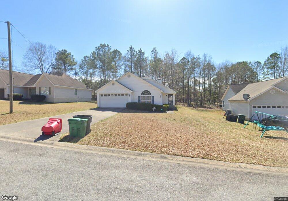
217 Bradstone Cir Macon, GA 31217
Estimated Value: $96,000 - $160,000
3
Beds
2
Baths
1,265
Sq Ft
$104/Sq Ft
Est. Value
About This Home
This home is located at 217 Bradstone Cir, Macon, GA 31217 and is currently estimated at $131,071, approximately $103 per square foot. 217 Bradstone Cir is a home located in Bibb County with nearby schools including Martin Luther King Jr. Elementary School, Appling Middle School, and Northeast High School.
Ownership History
Date
Name
Owned For
Owner Type
Purchase Details
Closed on
Feb 7, 2025
Sold by
Hill Beverly and West Beverly
Bought by
Destiny Properties Llc
Current Estimated Value
Purchase Details
Closed on
Apr 11, 2024
Sold by
Hill Beverly
Bought by
Destiny Properties Llc
Purchase Details
Closed on
Mar 24, 2004
Sold by
Multi-Prop Services Inc
Bought by
West Beverly D
Create a Home Valuation Report for This Property
The Home Valuation Report is an in-depth analysis detailing your home's value as well as a comparison with similar homes in the area
Home Values in the Area
Average Home Value in this Area
Purchase History
| Date | Buyer | Sale Price | Title Company |
|---|---|---|---|
| Destiny Properties Llc | -- | None Listed On Document | |
| Destiny Properties Llc | -- | None Listed On Document | |
| Destiny Properties Llc | $104,000 | None Listed On Document | |
| West Beverly D | $100 | -- |
Source: Public Records
Tax History Compared to Growth
Tax History
| Year | Tax Paid | Tax Assessment Tax Assessment Total Assessment is a certain percentage of the fair market value that is determined by local assessors to be the total taxable value of land and additions on the property. | Land | Improvement |
|---|---|---|---|---|
| 2025 | $1,079 | $43,913 | $5,200 | $38,713 |
| 2024 | $1,115 | $43,913 | $5,200 | $38,713 |
| 2023 | $1,115 | $43,913 | $5,200 | $38,713 |
| 2022 | $1,531 | $44,210 | $5,200 | $39,010 |
| 2021 | $1,140 | $30,007 | $4,000 | $26,007 |
| 2020 | $1,165 | $30,007 | $4,000 | $26,007 |
| 2019 | $1,175 | $30,007 | $4,000 | $26,007 |
| 2018 | $1,979 | $30,007 | $4,000 | $26,007 |
| 2017 | $1,124 | $30,007 | $4,000 | $26,007 |
| 2016 | $1,444 | $41,750 | $6,480 | $35,270 |
| 2015 | $2,045 | $41,750 | $6,480 | $35,270 |
| 2014 | $2,351 | $41,750 | $6,480 | $35,270 |
Source: Public Records
Map
Nearby Homes
- 2130 New Clinton Rd
- 2229 New Clinton Rd
- 2066 Melton Ave
- 2370 Recreation Rd
- 2146 Melton Ave
- 1840 Kinder Kare Dr
- 875 Artic Cir
- 1818 Kinder Kare Dr
- 2675 Andy Dr
- 837 Artic Cir
- 875 Artic Place
- 4436 Jeffersonville Rd
- 860 Morningside Dr
- 2720 Jordan Ave
- 909 Johnson St
- 2954 Tyler Place
- 2750 Lakeshore Dr
- 2458 Tredway Dr
- 2371 Kensington Rd
- 1008 Sunnydale Dr
- 221 Bradstone Cir
- 213 Bradstone Cir
- 304 Bradstone Ct
- 225 Bradstone Cir
- 179 Bradstone Cir
- 201 Bradstone Cir
- 183 Bradstone Cir
- 218 Bradstone Cir
- 218 Bradstone Cir Unit 43
- 214 Bradstone Cir
- 222 Bradstone Cir
- 308 Bradstone Ct
- 175 Bradstone Cir
- 175 Bradstone Cir Unit 57
- 229 Bradstone Cir
- 210 Bradstone Cir
- 226 Bradstone Cir
- 206 Bradstone Cir
- 235 Bradstone Cir
- 312 Bradstone Ct