Estimated Value: $836,346 - $917,000
3
Beds
3
Baths
1,653
Sq Ft
$522/Sq Ft
Est. Value
About This Home
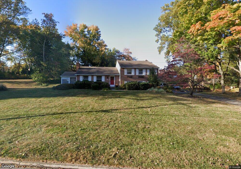
This home is located at 217 Brookmead Rd, Wayne, PA 19087 and is currently estimated at $862,587, approximately $521 per square foot. 217 Brookmead Rd is a home located in Chester County with nearby schools including Valley Forge Elementary School, Valley Forge Middle School, and Conestoga Senior High School.
Ownership History
Date
Name
Owned For
Owner Type
Purchase Details
Closed on
Oct 8, 2001
Sold by
Crenny Edward C
Bought by
Merrill Andrew M and Merrill Georgia A
Current Estimated Value
Home Financials for this Owner
Home Financials are based on the most recent Mortgage that was taken out on this home.
Original Mortgage
$252,800
Outstanding Balance
$99,172
Interest Rate
6.92%
Estimated Equity
$763,415
Create a Home Valuation Report for This Property
The Home Valuation Report is an in-depth analysis detailing your home's value as well as a comparison with similar homes in the area
Home Values in the Area
Average Home Value in this Area
Purchase History
| Date | Buyer | Sale Price | Title Company |
|---|---|---|---|
| Merrill Andrew M | $316,000 | -- |
Source: Public Records
Mortgage History
| Date | Status | Borrower | Loan Amount |
|---|---|---|---|
| Open | Merrill Andrew M | $252,800 |
Source: Public Records
Tax History
| Year | Tax Paid | Tax Assessment Tax Assessment Total Assessment is a certain percentage of the fair market value that is determined by local assessors to be the total taxable value of land and additions on the property. | Land | Improvement |
|---|---|---|---|---|
| 2025 | $7,173 | $203,630 | $61,820 | $141,810 |
| 2024 | $7,173 | $203,630 | $61,820 | $141,810 |
| 2023 | $6,737 | $203,630 | $61,820 | $141,810 |
| 2022 | $6,564 | $203,630 | $61,820 | $141,810 |
| 2021 | $6,439 | $203,630 | $61,820 | $141,810 |
| 2020 | $6,261 | $203,630 | $61,820 | $141,810 |
| 2019 | $6,063 | $203,630 | $61,820 | $141,810 |
| 2018 | $5,943 | $203,630 | $61,820 | $141,810 |
| 2017 | $5,802 | $203,630 | $61,820 | $141,810 |
| 2016 | -- | $203,630 | $61,820 | $141,810 |
| 2015 | -- | $203,630 | $61,820 | $141,810 |
| 2014 | -- | $203,630 | $61,820 | $141,810 |
Source: Public Records
Map
Nearby Homes
- 116 Chase Rd Unit 108
- 66 Old Forge Crossing Unit 66
- 278 Old Forge Crossing Unit 278
- 290 Musket Ln
- 4 Knox Ct
- 65 Le Forge Ct Unit 65
- 714 Gulph Rd
- 42 Drummers Ln
- 419 Drummers Ln Unit 419
- 176 Drummers Ln
- 134 Drummers Ln Unit 134
- 262 Drummers Ln Unit 262
- 275 Drummers Ln Unit 275
- 137 Drummers Ln
- 159 Drummers Ln Unit 159
- 71 Drummers Ln Unit 71
- 340 Coldstream Dr
- 170, 200, 220 Old State Rd
- 201 Springhouse Pond
- 910 Mountainview Dr Unit 910
- 1416 Woodford Dr
- 209 Brookmead Rd
- 1432 Woodford Dr
- 214 Brookmead Rd
- 1440 Woodford Dr
- 228 Brookmead Rd
- 1413 Woodford Dr
- 1409 Anthony Wayne Dr
- 1421 Woodford Dr
- 233 Brookmead Rd
- 226 Valerie Ln
- 1448 Woodford Dr
- 204 Brookmead Rd
- 1425 Anthony Wayne Dr
- 236 Brookmead Rd
- 1431 Woodford Dr
- 1435 Anthony Wayne Dr
- 1460 Woodford Dr
- 1439 Woodford Dr
- 1383 Anthony Wayne Dr
Your Personal Tour Guide
Ask me questions while you tour the home.