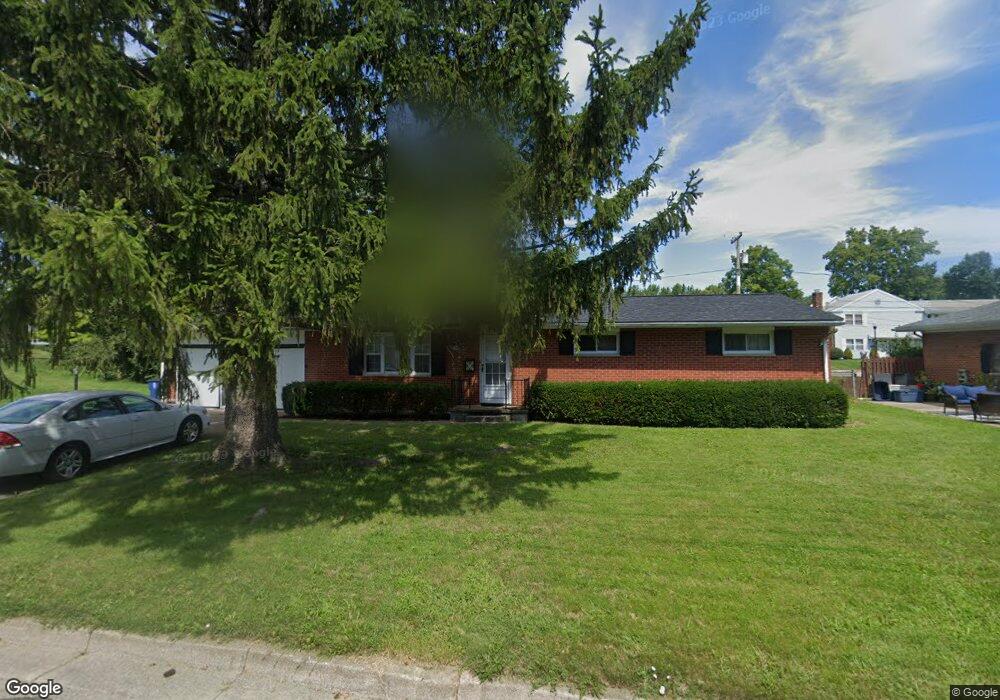
217 Curtis Dr Wilmington, OH 45177
Estimated Value: $220,546 - $257,000
3
Beds
2
Baths
1,836
Sq Ft
$134/Sq Ft
Est. Value
About This Home
This home is located at 217 Curtis Dr, Wilmington, OH 45177 and is currently estimated at $245,637, approximately $133 per square foot. 217 Curtis Dr is a home located in Clinton County with nearby schools including East End Elementary School, Denver Place Elementary School, and Roy E. Holmes Elementary School.
Ownership History
Date
Name
Owned For
Owner Type
Purchase Details
Closed on
Dec 31, 2002
Sold by
Mcbrayer Buell E
Bought by
Derickson Stanley P and Derickson Patricia A
Current Estimated Value
Home Financials for this Owner
Home Financials are based on the most recent Mortgage that was taken out on this home.
Original Mortgage
$99,000
Outstanding Balance
$42,204
Interest Rate
6.01%
Mortgage Type
New Conventional
Estimated Equity
$203,433
Purchase Details
Closed on
Nov 17, 1992
Bought by
Mcbrayer Wilma S
Create a Home Valuation Report for This Property
The Home Valuation Report is an in-depth analysis detailing your home's value as well as a comparison with similar homes in the area
Home Values in the Area
Average Home Value in this Area
Purchase History
| Date | Buyer | Sale Price | Title Company |
|---|---|---|---|
| Derickson Stanley P | $105,000 | -- | |
| Mcbrayer Wilma S | -- | -- |
Source: Public Records
Mortgage History
| Date | Status | Borrower | Loan Amount |
|---|---|---|---|
| Open | Derickson Stanley P | $99,000 |
Source: Public Records
Tax History Compared to Growth
Tax History
| Year | Tax Paid | Tax Assessment Tax Assessment Total Assessment is a certain percentage of the fair market value that is determined by local assessors to be the total taxable value of land and additions on the property. | Land | Improvement |
|---|---|---|---|---|
| 2024 | $1,790 | $53,310 | $9,070 | $44,240 |
| 2023 | $1,790 | $53,310 | $9,070 | $44,240 |
| 2022 | $1,457 | $40,830 | $8,220 | $32,610 |
| 2021 | $1,474 | $40,830 | $8,220 | $32,610 |
| 2020 | $1,386 | $40,830 | $8,220 | $32,610 |
| 2019 | $1,348 | $36,280 | $9,360 | $26,920 |
| 2018 | $1,361 | $36,280 | $9,360 | $26,920 |
| 2017 | $1,323 | $36,280 | $9,360 | $26,920 |
| 2016 | $1,214 | $32,900 | $9,100 | $23,800 |
| 2015 | $1,194 | $32,900 | $9,100 | $23,800 |
| 2013 | $1,245 | $33,880 | $9,100 | $24,780 |
Source: Public Records
Map
Nearby Homes
- 215 Leyland Park Dr Unit 1C
- 813 N Lincoln St
- 165 Lorish Ave
- 31 Fairland Ave
- 26 E Kentucky Ave
- Edmon Plan at Creekview
- Elder Plan at Creekview
- Sullivan Plan at Creekview
- Cabral Plan at Creekview
- Elm Plan at Creekview
- Pine Plan at Creekview
- 320 Lorish Ave
- 995 N South St
- 1005 N South St
- 987 N South St
- 1015 N South St
- 0 Mccoy Rd Unit 1761017
- 353 Hiatt Ave
- 619 Hiatt Ave
- 18 E Kentucky Ave
- 836 N Lincoln St
- 221 Leyland Park Dr
- 218 Curtis Dr
- 200 Curtis Dr
- 203 Leyland Park Dr
- 203 Leyland Park Dr Unit 1A
- 251 Curtis Dr
- 236 Curtis Dr
- 255 Leyland Park Dr
- 249 Leyland Park Dr
- 818 N Lincoln St
- 237 Leyland Park Dr Unit 2A
- 243 Leyland Park Dr
- 269 Curtis Dr
- 254 Curtis Dr
- 786 N Lincoln St
- 853 N Lincoln St
- 879 N Lincoln St
- 896 N Lincoln St
- 914 N Lincoln St