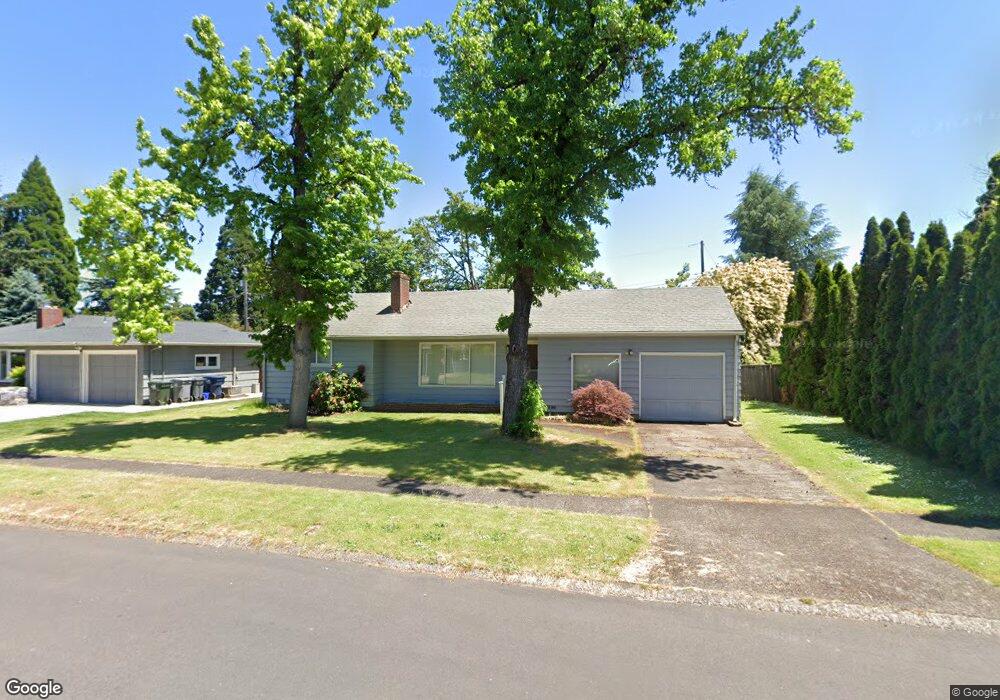
217 Hambletonian Dr Eugene, OR 97401
Harlow NeighborhoodEstimated Value: $419,734 - $503,000
3
Beds
1
Bath
1,050
Sq Ft
$447/Sq Ft
Est. Value
About This Home
This home is located at 217 Hambletonian Dr, Eugene, OR 97401 and is currently estimated at $469,684, approximately $447 per square foot. 217 Hambletonian Dr is a home located in Lane County with nearby schools including Holt Elementary School, Monroe Middle School, and Sheldon High School.
Ownership History
Date
Name
Owned For
Owner Type
Purchase Details
Closed on
Feb 26, 1998
Sold by
Jeffrey Maxwell and Jeffrey Carlene A
Bought by
Lehnert Alexander M and Lehnert Patricia L
Current Estimated Value
Home Financials for this Owner
Home Financials are based on the most recent Mortgage that was taken out on this home.
Original Mortgage
$108,000
Outstanding Balance
$18,347
Interest Rate
6.9%
Estimated Equity
$451,337
Create a Home Valuation Report for This Property
The Home Valuation Report is an in-depth analysis detailing your home's value as well as a comparison with similar homes in the area
Home Values in the Area
Average Home Value in this Area
Purchase History
| Date | Buyer | Sale Price | Title Company |
|---|---|---|---|
| Lehnert Alexander M | $120,190 | Fidelity National Title Ins |
Source: Public Records
Mortgage History
| Date | Status | Borrower | Loan Amount |
|---|---|---|---|
| Open | Lehnert Alexander M | $108,000 |
Source: Public Records
Tax History
| Year | Tax Paid | Tax Assessment Tax Assessment Total Assessment is a certain percentage of the fair market value that is determined by local assessors to be the total taxable value of land and additions on the property. | Land | Improvement |
|---|---|---|---|---|
| 2025 | $3,967 | $203,601 | -- | -- |
| 2024 | $3,918 | $197,671 | -- | -- |
| 2023 | $3,918 | $191,914 | $0 | $0 |
| 2022 | $3,670 | $186,325 | $0 | $0 |
| 2021 | $3,447 | $180,899 | $0 | $0 |
| 2020 | $3,459 | $175,631 | $0 | $0 |
| 2019 | $3,341 | $170,516 | $0 | $0 |
| 2018 | $3,145 | $160,728 | $0 | $0 |
| 2017 | $3,004 | $160,728 | $0 | $0 |
| 2016 | $2,929 | $156,047 | $0 | $0 |
| 2015 | $2,845 | $151,502 | $0 | $0 |
| 2014 | $2,788 | $147,089 | $0 | $0 |
Source: Public Records
Map
Nearby Homes
- 341 Ransom Ct
- 280 Regal Ct
- 2994 Dapple Way
- 3460 Oxbow Way
- 3579 Oxbow Way
- 2746 Harlow Rd
- 2872 Suffolk Ct
- 600 Cherry Dr Unit 8
- 347 Rustic Place Unit 14
- 2355 Pioneer Pike
- 825 Waverly St
- 446 Kodiak St
- 950 Coburg Rd
- 3360 Chevy Chase St
- 1038 President St
- 375 Mia Ln
- 820 Lariat Dr
- 3025 Bailey Ln
- 1130 Anderson Ln
- 1270 Calvin St
- 233 Hambletonian Dr
- 209 Hambletonian Dr
- 206 Fell Place
- 3147 Sorrel Way
- 237 Hambletonian Dr
- 230 Fell Place
- 208 Hambletonian Dr
- 236 Hambletonian Dr
- 234 Hambletonian Dr
- 255 Hambletonian Dr
- 196 Roan Dr
- 242 Roan Dr
- 3175 Sorrel Way
- 3074 Sorrel Way
- 250 Roan Dr
- 160 Roan Dr
- 258 Hambletonian Dr
- 3005 Sorrel Way
- 3110 Sorrel Way
- 225 Palomino Dr
Your Personal Tour Guide
Ask me questions while you tour the home.