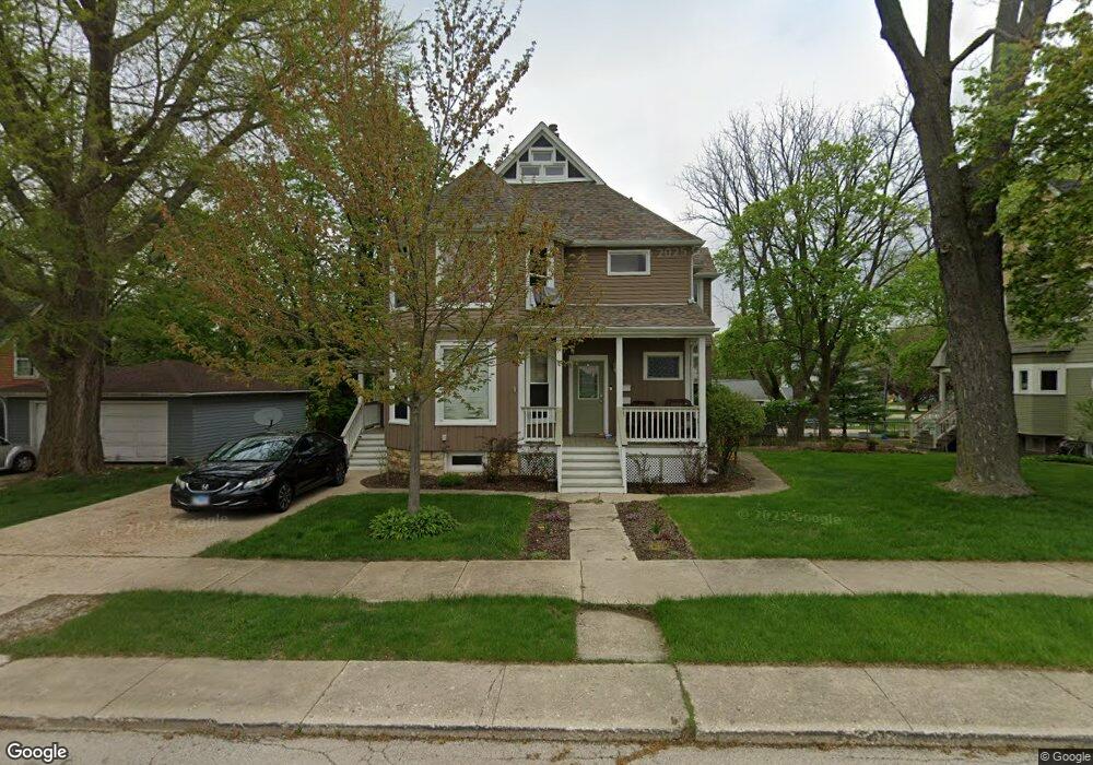
217 High St West Chicago, IL 60185
Chicago West NeighborhoodEstimated Value: $411,177 - $473,000
5
Beds
3
Baths
2,700
Sq Ft
$159/Sq Ft
Est. Value
About This Home
This home is located at 217 High St, West Chicago, IL 60185 and is currently estimated at $429,794, approximately $159 per square foot. 217 High St is a home located in DuPage County with nearby schools including Turner Elementary School, Leman Middle School, and West Chicago Community High School.
Ownership History
Date
Name
Owned For
Owner Type
Purchase Details
Closed on
Dec 12, 2016
Sold by
Meirick Michael F and Meirick Beverly A
Bought by
Barnes Benjamin
Current Estimated Value
Home Financials for this Owner
Home Financials are based on the most recent Mortgage that was taken out on this home.
Original Mortgage
$250,381
Outstanding Balance
$204,332
Interest Rate
3.87%
Mortgage Type
FHA
Estimated Equity
$225,462
Purchase Details
Closed on
May 31, 2001
Sold by
Judson Rose Ann
Bought by
Meirick Michael F and Meirick Beverly A
Home Financials for this Owner
Home Financials are based on the most recent Mortgage that was taken out on this home.
Original Mortgage
$134,400
Interest Rate
7.22%
Mortgage Type
Purchase Money Mortgage
Purchase Details
Closed on
Sep 24, 1999
Sold by
Judson Rose Ann
Bought by
Judson Rose Ann and The Rose Ann Judson Declaration Of Trust
Create a Home Valuation Report for This Property
The Home Valuation Report is an in-depth analysis detailing your home's value as well as a comparison with similar homes in the area
Home Values in the Area
Average Home Value in this Area
Purchase History
| Date | Buyer | Sale Price | Title Company |
|---|---|---|---|
| Barnes Benjamin | $255,000 | Git | |
| Meirick Michael F | $192,000 | -- | |
| Judson Rose Ann | -- | -- |
Source: Public Records
Mortgage History
| Date | Status | Borrower | Loan Amount |
|---|---|---|---|
| Open | Barnes Benjamin | $250,381 | |
| Previous Owner | Meirick Michael F | $134,400 |
Source: Public Records
Tax History Compared to Growth
Tax History
| Year | Tax Paid | Tax Assessment Tax Assessment Total Assessment is a certain percentage of the fair market value that is determined by local assessors to be the total taxable value of land and additions on the property. | Land | Improvement |
|---|---|---|---|---|
| 2024 | $9,677 | $116,881 | $27,132 | $89,749 |
| 2023 | $9,159 | $106,750 | $24,780 | $81,970 |
| 2022 | $8,875 | $99,770 | $23,160 | $76,610 |
| 2021 | $8,549 | $95,640 | $22,200 | $73,440 |
| 2020 | $8,382 | $92,740 | $21,530 | $71,210 |
| 2019 | $8,141 | $88,310 | $20,500 | $67,810 |
| 2018 | $7,812 | $83,300 | $19,330 | $63,970 |
| 2017 | $7,624 | $79,150 | $18,370 | $60,780 |
| 2016 | $7,408 | $73,800 | $17,130 | $56,670 |
| 2015 | $7,252 | $68,320 | $15,860 | $52,460 |
| 2014 | $7,077 | $66,350 | $15,400 | $50,950 |
| 2013 | $7,168 | $68,770 | $15,960 | $52,810 |
Source: Public Records
Map
Nearby Homes
- 200 Fulton St
- 228 Chicago St
- 128 S Oakwood Ave
- 209 E Washington St
- 130 Sophia St
- 125 Arbor Ave
- 515 Main St Unit 402
- 325 E York Ave
- 433 Virgie Place
- 212 N Oakwood Ave
- 550 Main St Unit 215
- 348 Arbor Ave
- 143 Conde St
- 247 N Neltnor Blvd Unit H1C
- 129 W Blair St
- 713 E Elmwood Ave
- 527 Fremont St
- 421 N Neltnor Blvd
- 536 Fremont St
- 1N175 Ridgeland Ave