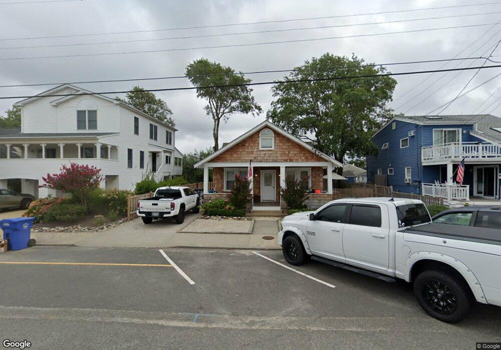
217 Pearl St Beach Haven, NJ 08008
Long Beach Island NeighborhoodEstimated Value: $1,025,000 - $1,854,000
2
Beds
1
Bath
2,000
Sq Ft
$696/Sq Ft
Est. Value
About This Home
This home is located at 217 Pearl St, Beach Haven, NJ 08008 and is currently estimated at $1,391,988, approximately $695 per square foot. 217 Pearl St is a home located in Ocean County with nearby schools including Beach Haven School, Southern Regional Middle School, and Southern Regional High School.
Ownership History
Date
Name
Owned For
Owner Type
Purchase Details
Closed on
Sep 26, 2022
Sold by
Johnson Reed
Bought by
Borough Of Beach Haven
Current Estimated Value
Purchase Details
Closed on
Mar 31, 2021
Sold by
Olen Elliot Mark and Estate Of Lois R Mosley
Bought by
Johnson Reed and Johnson Abigail
Home Financials for this Owner
Home Financials are based on the most recent Mortgage that was taken out on this home.
Original Mortgage
$596,250
Interest Rate
3%
Mortgage Type
New Conventional
Purchase Details
Closed on
Mar 3, 2021
Sold by
Mosley Lois R and Olen Elliot Mark
Bought by
Johnson Reed and Johnson Abigail
Home Financials for this Owner
Home Financials are based on the most recent Mortgage that was taken out on this home.
Original Mortgage
$596,250
Interest Rate
3%
Mortgage Type
New Conventional
Purchase Details
Closed on
Dec 31, 1988
Bought by
Mousley Lois R
Create a Home Valuation Report for This Property
The Home Valuation Report is an in-depth analysis detailing your home's value as well as a comparison with similar homes in the area
Home Values in the Area
Average Home Value in this Area
Purchase History
| Date | Buyer | Sale Price | Title Company |
|---|---|---|---|
| Borough Of Beach Haven | -- | -- | |
| Johnson Reed | $795,000 | Foundation Title Llc | |
| Johnson Reed | $795,000 | Land Title | |
| Mousley Lois R | $100 | -- |
Source: Public Records
Mortgage History
| Date | Status | Borrower | Loan Amount |
|---|---|---|---|
| Previous Owner | Johnson Reed | $596,250 | |
| Previous Owner | Johnson Reed | $596,250 |
Source: Public Records
Tax History Compared to Growth
Tax History
| Year | Tax Paid | Tax Assessment Tax Assessment Total Assessment is a certain percentage of the fair market value that is determined by local assessors to be the total taxable value of land and additions on the property. | Land | Improvement |
|---|---|---|---|---|
| 2025 | $11,550 | $880,300 | $630,000 | $250,300 |
| 2024 | $10,660 | $880,300 | $630,000 | $250,300 |
| 2023 | $8,715 | $774,700 | $630,000 | $144,700 |
| 2022 | $8,715 | $774,700 | $630,000 | $144,700 |
| 2021 | $8,294 | $756,100 | $630,000 | $126,100 |
| 2020 | $8,476 | $756,100 | $630,000 | $126,100 |
| 2019 | $8,234 | $756,100 | $630,000 | $126,100 |
| 2018 | $8,521 | $756,100 | $630,000 | $126,100 |
| 2017 | $8,136 | $756,100 | $630,000 | $126,100 |
| 2016 | $7,524 | $567,400 | $475,000 | $92,400 |
| 2015 | $7,200 | $567,400 | $475,000 | $92,400 |
| 2014 | $6,809 | $567,400 | $475,000 | $92,400 |
Source: Public Records
Map
Nearby Homes
- 204 Coral St
- 132 Coral St
- 20 Amber St Unit E3
- 310 W West Ave Unit 2E
- 109 Centre St
- 507 Amber Street U-B
- 1 Centre St Unit 1
- 507 Amber St Unit B
- 320 3rd St
- 301 N Beach Ave
- 317 3rd St
- 27 3rd St
- 225 4th St
- 100 Northwest Ave
- 415 N Bay Ave Unit C
- 415 N Bay Ave Unit B
- 415 N Bay Ave Unit D
- 415 N Bay Ave Unit A
- 224 5th St Unit A
- 224 5th St