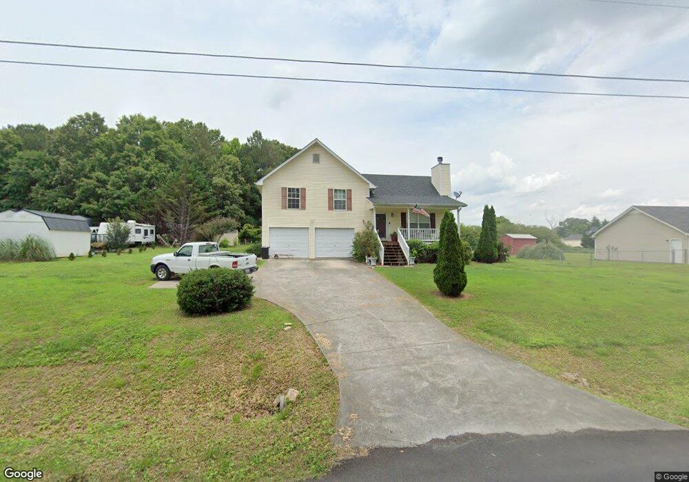
217 Shaw Rd SW Adairsville, GA 30103
Estimated Value: $242,000 - $273,000
3
Beds
2
Baths
1,144
Sq Ft
$223/Sq Ft
Est. Value
About This Home
This home is located at 217 Shaw Rd SW, Adairsville, GA 30103 and is currently estimated at $254,826, approximately $222 per square foot. 217 Shaw Rd SW is a home located in Gordon County with nearby schools including Swain Elementary School, Ashworth Middle School, and Gordon Central High School.
Ownership History
Date
Name
Owned For
Owner Type
Purchase Details
Closed on
Mar 1, 2021
Sold by
Laboard Cheryl Jones
Bought by
Jones Asenath
Current Estimated Value
Purchase Details
Closed on
Apr 14, 2003
Sold by
Collis Builders Inc
Bought by
Jones Asenath and Jones Cheryl
Purchase Details
Closed on
Jul 5, 2002
Sold by
Collis Ronald V
Bought by
Collis Builders Inc
Create a Home Valuation Report for This Property
The Home Valuation Report is an in-depth analysis detailing your home's value as well as a comparison with similar homes in the area
Home Values in the Area
Average Home Value in this Area
Purchase History
| Date | Buyer | Sale Price | Title Company |
|---|---|---|---|
| Jones Asenath | -- | -- | |
| Jones Asenath | $102,600 | -- | |
| Collis Builders Inc | $14,000 | -- |
Source: Public Records
Tax History Compared to Growth
Tax History
| Year | Tax Paid | Tax Assessment Tax Assessment Total Assessment is a certain percentage of the fair market value that is determined by local assessors to be the total taxable value of land and additions on the property. | Land | Improvement |
|---|---|---|---|---|
| 2024 | -- | $73,920 | $6,000 | $67,920 |
| 2023 | $1,858 | $69,360 | $6,000 | $63,360 |
| 2022 | $1,858 | $64,840 | $6,000 | $58,840 |
| 2021 | $1,402 | $48,928 | $6,000 | $42,928 |
| 2020 | $1,423 | $49,420 | $6,000 | $43,420 |
| 2019 | $1,479 | $49,420 | $6,000 | $43,420 |
| 2018 | $0 | $42,920 | $3,920 | $39,000 |
| 2017 | $1,224 | $40,880 | $3,920 | $36,960 |
| 2016 | $1,224 | $40,880 | $3,920 | $36,960 |
| 2015 | -- | $40,160 | $3,920 | $36,240 |
| 2014 | -- | $38,483 | $3,920 | $34,563 |
Source: Public Records
Map
Nearby Homes
- 269 Riverboat Dr
- Woodridge Plan at The Landing at Miller’s Ferry
- Kensington Plan at The Landing at Miller’s Ferry
- Northwyck Plan at The Landing at Miller’s Ferry
- Richmond Plan at The Landing at Miller’s Ferry
- Brookhaven Plan at The Landing at Miller’s Ferry
- Newport I Plan at The Landing at Miller’s Ferry
- Wesley Plan at The Landing at Miller’s Ferry
- Newport II Plan at The Landing at Miller’s Ferry
- Richardson Plan at The Landing at Miller’s Ferry
- Dewhurst Plan at The Landing at Miller’s Ferry
- 178 Harbor Trail
- 365 Riverboat Dr
- 238 Lighthouse Cove SW
- 51 Robin Rd
- 58 Thacker Trail
- 172 Graham Cir
- 166 Graham Cir
- 0 Woody Rd NW Unit 10634615
- 38 Woody Way NW
- 231 Shaw Rd SW
- 182 Terry Ln
- 192 Terry Ln
- 193 Shaw Rd SW
- 243 Shaw Rd SW
- 162 Terry Ln
- 197 Terry Ln
- 181 Shaw Rd SW
- 255 Shaw Rd SW
- 189 Terry Ln
- 144 Terry Ln
- 155 Terry Ln
- 171 Terry Ln
- 167 Shaw Rd SW
- 262 Shaw Rd SW
- 0 Terry Ln Unit 7069467
- 0 Terry Ln Unit 8319205
- 0 Terry Ln Unit 8714454
- 0 Terry Ln Unit 3288938
- 130 Terry Ln