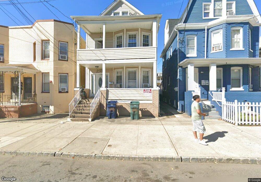
217 Sherman St Perth Amboy, NJ 08861
Southwestern Perth Amboy NeighborhoodEstimated Value: $476,072 - $566,000
--
Bed
--
Bath
1,928
Sq Ft
$272/Sq Ft
Est. Value
About This Home
This home is located at 217 Sherman St, Perth Amboy, NJ 08861 and is currently estimated at $524,768, approximately $272 per square foot. 217 Sherman St is a home located in Middlesex County with nearby schools including Perth Amboy High School, Middlesex County STEM Charter School, and Academy for Urban Leadership Charter School.
Ownership History
Date
Name
Owned For
Owner Type
Purchase Details
Closed on
Oct 15, 2013
Sold by
Valdez Adriana and Rivera Omar
Bought by
Niemeyer Richard W and Niemeyer Xiaoying
Current Estimated Value
Home Financials for this Owner
Home Financials are based on the most recent Mortgage that was taken out on this home.
Original Mortgage
$140,000
Outstanding Balance
$104,128
Interest Rate
4.24%
Mortgage Type
New Conventional
Estimated Equity
$420,641
Create a Home Valuation Report for This Property
The Home Valuation Report is an in-depth analysis detailing your home's value as well as a comparison with similar homes in the area
Home Values in the Area
Average Home Value in this Area
Purchase History
| Date | Buyer | Sale Price | Title Company |
|---|---|---|---|
| Niemeyer Richard W | $200,000 | Chicago Title Insurance Co |
Source: Public Records
Mortgage History
| Date | Status | Borrower | Loan Amount |
|---|---|---|---|
| Open | Niemeyer Richard W | $140,000 |
Source: Public Records
Tax History Compared to Growth
Tax History
| Year | Tax Paid | Tax Assessment Tax Assessment Total Assessment is a certain percentage of the fair market value that is determined by local assessors to be the total taxable value of land and additions on the property. | Land | Improvement |
|---|---|---|---|---|
| 2025 | $7,313 | $242,400 | $86,400 | $156,000 |
| 2024 | $7,299 | $242,400 | $86,400 | $156,000 |
| 2023 | $7,299 | $242,400 | $86,400 | $156,000 |
| 2022 | $7,211 | $242,400 | $86,400 | $156,000 |
| 2021 | $7,221 | $242,400 | $86,400 | $156,000 |
| 2020 | $7,219 | $242,400 | $86,400 | $156,000 |
| 2019 | $7,245 | $242,400 | $86,400 | $156,000 |
| 2018 | $7,182 | $242,400 | $86,400 | $156,000 |
| 2017 | $7,168 | $242,400 | $86,400 | $156,000 |
| 2016 | $6,981 | $242,400 | $86,400 | $156,000 |
| 2015 | $7,030 | $242,400 | $86,400 | $156,000 |
| 2014 | $7,073 | $242,400 | $86,400 | $156,000 |
Source: Public Records
Map
Nearby Homes
- 371 Mcguire Place
- 278 Market St
- 267 Elm St
- 203 Gordon St
- 206 Market St
- 374 Oak St
- 187 Gordon St
- 136 1st St
- 397 Washington St
- 303 Holly Dr
- 402 Hidden Village Dr
- 306 Holly Dr Unit 306
- 404 Washington St
- 309 Hidden Village Dr
- 307 Hidden Village Dr
- 190 Lewis St
- 1002 Hidden Village Dr
- 376 Barclay St
- 448 Baker Place
- 461 Lawrie St
- 211 Sherman St Unit 215A
- 219 Sherman St
- 221 Sherman St
- 209 Sherman St
- 218 Sheridan St
- 216 Sheridan St
- 223 Sherman St
- 220 Sheridan St
- 222 Sheridan St
- 212 Sheridan St
- 210 Sheridan St
- 227 Sherman St
- 226 Sheridan St
- 224 Sheridan St
- 224 Sheridan St Unit 2
- 224 Sheridan St Unit 1
- 218 Sherman St
- 220 Sherman St
- 212 Sherman St
- 222 Sherman St