Estimated Value: $248,437 - $342,000
4
Beds
2
Baths
1,404
Sq Ft
$205/Sq Ft
Est. Value
About This Home
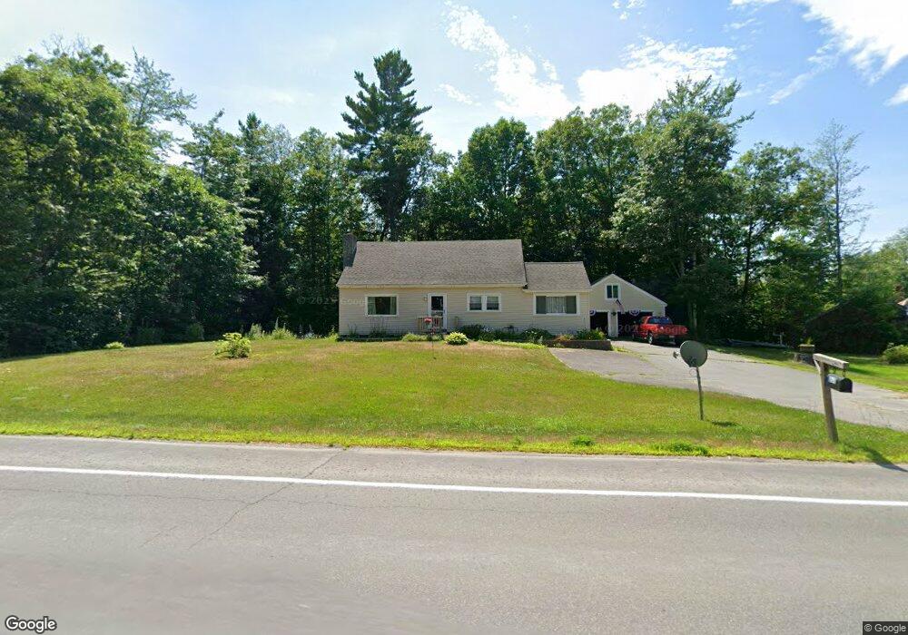
This home is located at 217 Thorndike Rd, Unity, ME 04988 and is currently estimated at $288,359, approximately $205 per square foot. 217 Thorndike Rd is a home located in Waldo County with nearby schools including Mt. View Middle School, Mt. View High School, and Ecology Learning Center.
Create a Home Valuation Report for This Property
The Home Valuation Report is an in-depth analysis detailing your home's value as well as a comparison with similar homes in the area
Tax History
| Year | Tax Paid | Tax Assessment Tax Assessment Total Assessment is a certain percentage of the fair market value that is determined by local assessors to be the total taxable value of land and additions on the property. | Land | Improvement |
|---|---|---|---|---|
| 2025 | $2,580 | $229,800 | $45,200 | $184,600 |
| 2024 | $2,580 | $170,300 | $33,500 | $136,800 |
| 2022 | $2,166 | $136,200 | $26,800 | $109,400 |
| 2021 | $2,200 | $136,200 | $26,800 | $109,400 |
| 2020 | $2,377 | $136,200 | $26,800 | $109,400 |
| 2019 | $2,377 | $136,200 | $26,800 | $109,400 |
| 2018 | $2,281 | $136,200 | $26,800 | $109,400 |
| 2017 | $2,268 | $136,200 | $26,800 | $109,400 |
| 2016 | $2,295 | $136,200 | $26,800 | $109,400 |
| 2014 | $2,016 | $136,200 | $26,800 | $109,400 |
| 2013 | $1,825 | $136,200 | $26,800 | $109,400 |
Source: Public Records
Map
Nearby Homes
- M12 L31-3 Stage Coach Rd
- 156 Depot St
- Pond View Subdivision Us-202
- 23 Bangor Rd
- 173 Main St
- Lot 45-1 Maine 220
- 13 Chestnut St
- 5 Chestnut St
- 126 Newell Ct
- Lot # 5 Locust Ln
- 391 School St
- 44 Charles Taylor Ln
- 126 Rancourt Ln
- M11L10 Gordon Hill Rd
- 87 Pond Rd
- Lot 12 Moulton Hill Ln
- Lot 13 Moulton Hill Ln
- 309 Pond Rd
- 194 E Gulch Rd
- Lot 3-1 Bryant Rd
- Lot #1 Thorndike Road (Route 139 220)
- 230 Thorndike Rd
- 233 Thorndike Rd
- 0 Stagecoach Rd Unit 785086
- 0 Stagecoach Rd Unit 1139432
- 257 Depot St
- Lot 2 Thorndike Road (Route 139 220)
- Lot 2 Thorndike Rd
- 241 Depot St
- 225 Depot St
- M 12 L 31 Route 220 and Back Troy Rd
- 13 Stagecoach Rd
- 240 Depot St
- 29 Stagecoach Rd Unit 29A
- 29 Stagecoach Rd
- 32 Stagecoach Rd Unit 32B
- 36 Stagecoach Rd Unit 36B
- 205 Depot St
- 39 Stagecoach Rd Unit 39B
- Lot36-37 Stagecoach Rd
Your Personal Tour Guide
Ask me questions while you tour the home.