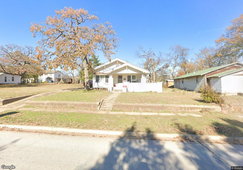
217 W 7th Ave Bristow, OK 74010
Estimated Value: $119,000 - $142,000
3
Beds
1
Bath
1,252
Sq Ft
$105/Sq Ft
Est. Value
About This Home
This home is located at 217 W 7th Ave, Bristow, OK 74010 and is currently estimated at $131,577, approximately $105 per square foot. 217 W 7th Ave is a home located in Creek County with nearby schools including Edison Elementary School, Collins Elementary School, and Bristow Middle School.
Ownership History
Date
Name
Owned For
Owner Type
Purchase Details
Closed on
Aug 22, 2024
Sold by
Latigrid Holdings Llc
Bought by
Deeringwater Aspen and Deeringwater Matthew
Current Estimated Value
Home Financials for this Owner
Home Financials are based on the most recent Mortgage that was taken out on this home.
Original Mortgage
$121,212
Outstanding Balance
$119,817
Interest Rate
6.78%
Mortgage Type
New Conventional
Estimated Equity
$11,760
Purchase Details
Closed on
Sep 20, 2023
Sold by
Latigrid Holdings Llc
Bought by
Armer Michael
Purchase Details
Closed on
May 15, 2023
Sold by
Nelson Michael
Bought by
Latigrid Holdings Llc
Home Financials for this Owner
Home Financials are based on the most recent Mortgage that was taken out on this home.
Original Mortgage
$132,750
Interest Rate
6.43%
Mortgage Type
Credit Line Revolving
Create a Home Valuation Report for This Property
The Home Valuation Report is an in-depth analysis detailing your home's value as well as a comparison with similar homes in the area
Home Values in the Area
Average Home Value in this Area
Purchase History
| Date | Buyer | Sale Price | Title Company |
|---|---|---|---|
| Deeringwater Aspen | $120,000 | Oklahoma Secured Title | |
| Armer Michael | -- | Westcor Land Title | |
| Latigrid Holdings Llc | $115,000 | None Listed On Document |
Source: Public Records
Mortgage History
| Date | Status | Borrower | Loan Amount |
|---|---|---|---|
| Open | Deeringwater Aspen | $121,212 | |
| Previous Owner | Latigrid Holdings Llc | $132,750 |
Source: Public Records
Tax History
| Year | Tax Paid | Tax Assessment Tax Assessment Total Assessment is a certain percentage of the fair market value that is determined by local assessors to be the total taxable value of land and additions on the property. | Land | Improvement |
|---|---|---|---|---|
| 2025 | $1,403 | $14,269 | $1,728 | $12,541 |
| 2024 | $1,474 | $14,994 | $1,440 | $13,554 |
| 2023 | $1,474 | $13,728 | $1,440 | $12,288 |
| 2022 | $430 | $4,495 | $1,186 | $3,309 |
| 2021 | $411 | $4,282 | $1,180 | $3,102 |
| 2020 | $378 | $4,078 | $1,171 | $2,907 |
| 2019 | $363 | $3,884 | $1,163 | $2,721 |
| 2018 | $338 | $3,523 | $1,090 | $2,433 |
| 2017 | $323 | $3,355 | $1,028 | $2,327 |
| 2016 | $312 | $3,196 | $969 | $2,227 |
| 2015 | -- | $3,043 | $912 | $2,131 |
| 2014 | -- | $2,899 | $859 | $2,040 |
Source: Public Records
Map
Nearby Homes
- 32380 W Highway 33
- 106 N Main St
- 0 State Highway 48
- 602 W 7th Ave
- 551 W 10th Ave
- 516 W 11th Ave
- 302 E 8th Ave
- 410 S Roland St
- 810 S Walnut
- 619 E 6th Ave
- 610 E 4th Ave
- 1001 S Chestnut St
- 904 S Hickory St
- 1109 S Chestnut St
- 508 E Grant Place
- 1219 S Poplar Place
- 504 E Pershing Place
- 34335 W Highway 16
- 805 E Tejon Ave
- 1421 S Cedar St
Your Personal Tour Guide
Ask me questions while you tour the home.