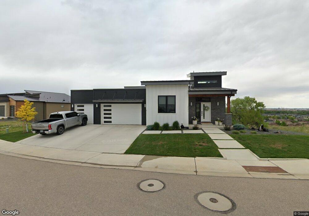
2171 Picture Pointe Dr Windsor, CO 80550
Water Valley NeighborhoodEstimated Value: $1,133,000 - $1,273,000
3
Beds
4
Baths
2,543
Sq Ft
$471/Sq Ft
Est. Value
About This Home
This home is located at 2171 Picture Pointe Dr, Windsor, CO 80550 and is currently estimated at $1,198,826, approximately $471 per square foot. 2171 Picture Pointe Dr is a home located in Weld County with nearby schools including Tozer Elementary School, Mountain View Elementary School, and Windsor Middle School.
Ownership History
Date
Name
Owned For
Owner Type
Purchase Details
Closed on
May 26, 2021
Sold by
Victor B Miller & Susan D Miller 2017 Re
Bought by
Hardy Jay Mark and Hardy Nancy Lynn
Current Estimated Value
Home Financials for this Owner
Home Financials are based on the most recent Mortgage that was taken out on this home.
Original Mortgage
$760,000
Outstanding Balance
$684,699
Interest Rate
3%
Mortgage Type
New Conventional
Estimated Equity
$514,127
Purchase Details
Closed on
May 17, 2019
Sold by
Juma Llc
Bought by
Victor B Miller & Susan D Miller 2017 Re
Purchase Details
Closed on
Dec 21, 2018
Sold by
Eagle Crossing Development Inc
Bought by
Juma Llc
Create a Home Valuation Report for This Property
The Home Valuation Report is an in-depth analysis detailing your home's value as well as a comparison with similar homes in the area
Home Values in the Area
Average Home Value in this Area
Purchase History
We collect this data history from publicly available records. To have your information removed, we recommend requesting removal directly through your county’s website.
| Date | Buyer | Sale Price | Title Company |
|---|---|---|---|
| Hardy Jay Mark | $950,000 | Land Title Guarantee Co | |
| Victor B Miller & Susan D Miller 2017 Re | $985,000 | Land Title Guarantee Co | |
| Juma Llc | -- | None Available |
Source: Public Records
Mortgage History
We collect this data history from publicly available records. To have your information removed, we recommend requesting removal directly through your county’s website.
| Date | Status | Borrower | Loan Amount |
|---|---|---|---|
| Open | Hardy Jay Mark | $760,000 |
Source: Public Records
Tax History
| Year | Tax Paid | Tax Assessment Tax Assessment Total Assessment is a certain percentage of the fair market value that is determined by local assessors to be the total taxable value of land and additions on the property. | Land | Improvement |
|---|---|---|---|---|
| 2025 | $9,673 | $72,250 | $25,000 | $47,250 |
| 2024 | $9,673 | $72,250 | $25,000 | $47,250 |
| 2023 | $8,917 | $75,100 | $16,910 | $58,190 |
| 2022 | $8,677 | $61,870 | $17,380 | $44,490 |
| 2021 | $8,070 | $61,950 | $17,880 | $44,070 |
| 2020 | $6,010 | $46,740 | $12,510 | $34,230 |
| 2019 | $2,039 | $15,950 | $15,950 | $0 |
| 2018 | $646 | $4,900 | $4,900 | $0 |
| 2017 | $408 | $3,020 | $3,020 | $0 |
| 2016 | $190 | $1,420 | $1,420 | $0 |
| 2015 | $181 | $1,420 | $1,420 | $0 |
| 2014 | $168 | $1,260 | $1,260 | $0 |
Source: Public Records
Map
Nearby Homes
- 2177 Picture Point Dr
- 101 Siesta Key Ct
- 2086 Cape Hatteras Dr
- 2036 Vineyard Ct
- 2084 Bayfront Dr
- 2047 Bayfront Dr
- 189 Kitty Hawk Ct
- 2336 Golden Way
- 216 Siesta Key Dr
- 2366 Blissful Ln
- 2169 Longfin Dr
- 2175 Longfin Dr
- 2178 Cape Hatteras Dr Unit 246
- 2178 Cape Hatteras Dr Unit 247
- 2083 Vineyard Dr
- 2177 Cape Hatteras Dr Unit 1
- 2006 Vineyard Dr
- 2078 Vineyard Dr
- 1979 Cayman Dr
- 2304 Sublime Dr
- 2171 Picture Point Dr
- 2171 Picture Pointe Dr
- 2173 Picture Point Dr
- 2167 Picture Point Dr
- 2167 Picture Pointe Dr
- 2175 Picture Point Dr
- 2175 Picture Pointe Dr
- 2163 Picture Point Dr
- 2159 Picture Point Dr
- 2179 Picture Point Dr
- 2155 Picture Point Dr
- 2179 Sky End Dr
- 2179 Sky End Dr
- 2181 Picture Point Dr
- 2151 Picture Point Dr
- 2183 Picture Point Dr
- 2147 Picture Pointe Dr
- 2147 Picture Point Dr
- 2187 Picture Point Dr
- 2145 Picture Point Dr
Your Personal Tour Guide
Ask me questions while you tour the home.