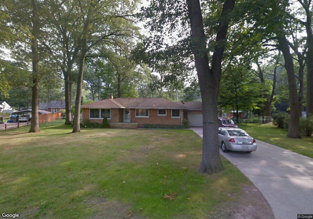
2171 S Manitou Cir Norton Shores, MI 49441
Estimated Value: $280,000 - $298,962
3
Beds
2
Baths
1,780
Sq Ft
$163/Sq Ft
Est. Value
About This Home
This home is located at 2171 S Manitou Cir, Norton Shores, MI 49441 and is currently estimated at $290,741, approximately $163 per square foot. 2171 S Manitou Cir is a home located in Muskegon County with nearby schools including Mona Shores High School, Muskegon Montessori Academy for Environmental Change, and St. Francis De Sales Elementary School.
Ownership History
Date
Name
Owned For
Owner Type
Purchase Details
Closed on
Dec 23, 2005
Sold by
The Jane Ann S Dobb Trust
Bought by
Mcpeak Billy G and Mcpeak Kay M
Current Estimated Value
Home Financials for this Owner
Home Financials are based on the most recent Mortgage that was taken out on this home.
Original Mortgage
$106,500
Outstanding Balance
$59,976
Interest Rate
6.4%
Mortgage Type
Fannie Mae Freddie Mac
Estimated Equity
$230,765
Create a Home Valuation Report for This Property
The Home Valuation Report is an in-depth analysis detailing your home's value as well as a comparison with similar homes in the area
Home Values in the Area
Average Home Value in this Area
Purchase History
| Date | Buyer | Sale Price | Title Company |
|---|---|---|---|
| Mcpeak Billy G | $107,000 | None Available |
Source: Public Records
Mortgage History
| Date | Status | Borrower | Loan Amount |
|---|---|---|---|
| Open | Mcpeak Billy G | $106,500 |
Source: Public Records
Tax History Compared to Growth
Tax History
| Year | Tax Paid | Tax Assessment Tax Assessment Total Assessment is a certain percentage of the fair market value that is determined by local assessors to be the total taxable value of land and additions on the property. | Land | Improvement |
|---|---|---|---|---|
| 2025 | $2,314 | $125,400 | $0 | $0 |
| 2024 | $1,814 | $116,200 | $0 | $0 |
| 2023 | $1,732 | $102,600 | $0 | $0 |
| 2022 | $2,112 | $89,500 | $0 | $0 |
| 2021 | $2,052 | $81,800 | $0 | $0 |
| 2020 | $2,029 | $65,200 | $0 | $0 |
| 2019 | $1,991 | $58,600 | $0 | $0 |
| 2018 | $1,945 | $56,400 | $0 | $0 |
| 2017 | $1,900 | $54,800 | $0 | $0 |
| 2016 | $1,471 | $51,100 | $0 | $0 |
| 2015 | -- | $49,000 | $0 | $0 |
| 2014 | $1,765 | $48,900 | $0 | $0 |
| 2013 | -- | $45,800 | $0 | $0 |
Source: Public Records
Map
Nearby Homes
- 2115 Garland Dr
- 2298 Norcrest Dr
- 2059 Garland Dr
- 1947 Spencer Dr
- 2263 Lawnel Ave
- 3283 Mccracken St
- 2290 Blissfield Ct
- 1936 Lawnel Ave
- 2280 Arbor Ave
- 4057 Dunes Pkwy
- 3658 Lake Harbor Rd
- 1905 Crestwood Ln
- 2278 Reneer Ave
- 1744 W Norton Ave
- 2097 Geneva Ln
- 1733 Woodside Rd
- 3507 Winnetaska Rd
- 3891 Wickham Dr
- 1812 Ritter Hills Dr
- 3681 Brentwood St Unit 24
- 2157 S Manitou Cir
- 2174 Seminole Rd
- 2160 Seminole Rd
- 2186 Seminole Rd
- 3540 W Manitou Cir
- 2137 S Manitou Cir
- 2148 Seminole Rd
- 3537 W Manitou Cir
- 3526 W Manitou Cir
- 2131 S Manitou Cir
- 2134 Seminole Rd
- 3541 Seneca Dr
- 2171 Seminole Rd
- 3521 W Manitou Cir
- 2183 Seminole Rd
- 2159 Seminole Rd
- 2195 Seminole Rd
- 3525 Seneca Dr
- 3512 W Manitou Cir
- 2147 Seminole Rd