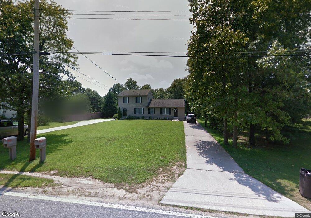
2171 W Oak Rd Vineland, NJ 08360
Estimated Value: $282,252 - $475,000
--
Bed
--
Bath
2,320
Sq Ft
$158/Sq Ft
Est. Value
About This Home
This home is located at 2171 W Oak Rd, Vineland, NJ 08360 and is currently estimated at $366,063, approximately $157 per square foot. 2171 W Oak Rd is a home located in Cumberland County with nearby schools including Marie D. Durand Elementary School, T.W. Wallace Middle School, and Vineland Senior High School.
Ownership History
Date
Name
Owned For
Owner Type
Purchase Details
Closed on
Aug 18, 2021
Sold by
Cromley Donald K and Cromley Stephanie A
Bought by
Cromley Donald K
Current Estimated Value
Purchase Details
Closed on
Dec 2, 2004
Purchase Details
Closed on
Oct 18, 2002
Sold by
Brandt Construction Llc
Bought by
Brandt Jason
Home Financials for this Owner
Home Financials are based on the most recent Mortgage that was taken out on this home.
Original Mortgage
$120,000
Interest Rate
6.2%
Mortgage Type
Purchase Money Mortgage
Create a Home Valuation Report for This Property
The Home Valuation Report is an in-depth analysis detailing your home's value as well as a comparison with similar homes in the area
Home Values in the Area
Average Home Value in this Area
Purchase History
| Date | Buyer | Sale Price | Title Company |
|---|---|---|---|
| Cromley Donald K | -- | None Available | |
| -- | $215,000 | -- | |
| Brandt Jason | $155,000 | -- |
Source: Public Records
Mortgage History
| Date | Status | Borrower | Loan Amount |
|---|---|---|---|
| Previous Owner | Brandt Jason | $120,000 |
Source: Public Records
Tax History Compared to Growth
Tax History
| Year | Tax Paid | Tax Assessment Tax Assessment Total Assessment is a certain percentage of the fair market value that is determined by local assessors to be the total taxable value of land and additions on the property. | Land | Improvement |
|---|---|---|---|---|
| 2025 | $5,550 | $174,300 | $33,400 | $140,900 |
| 2024 | $5,550 | $174,300 | $33,400 | $140,900 |
| 2023 | $5,513 | $174,300 | $33,400 | $140,900 |
| 2022 | $5,349 | $174,300 | $33,400 | $140,900 |
| 2021 | $5,252 | $174,300 | $33,400 | $140,900 |
| 2020 | $5,102 | $174,300 | $33,400 | $140,900 |
| 2019 | $5,032 | $174,300 | $33,400 | $140,900 |
| 2018 | $4,900 | $174,300 | $33,400 | $140,900 |
| 2017 | $4,654 | $174,300 | $33,400 | $140,900 |
| 2016 | $4,490 | $174,300 | $33,400 | $140,900 |
| 2015 | $4,324 | $174,300 | $33,400 | $140,900 |
| 2014 | $4,089 | $174,300 | $33,400 | $140,900 |
Source: Public Records
Map
Nearby Homes
- 1469 N Mill Rd
- 1500 Venus Dr
- 1429 W Oak Rd
- 1252 W Oak Rd
- 1799 W Landis Ave
- 834 Gershal Ave
- 0 Levishohn St
- 1535 W Landis Ave
- 58 Wallace St
- 1457 W Landis Ave
- 1489 N Delsea Dr
- 765 Gershal Ave
- 1811 N Delsea Dr Unit 4
- 829 W Garden Rd
- 663 Wayne Ave
- 0 W Landis Ave
- 342 S Orchard Rd
- 550 Northwest Ave
- 47 Maple Shade Ln
- L 1 & 1.01 Shiff Ave