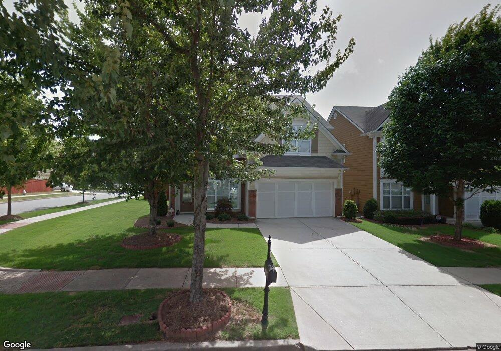
2173 Worrall Hill Dr Duluth, GA 30096
Estimated Value: $485,838 - $516,000
4
Beds
3
Baths
2,261
Sq Ft
$221/Sq Ft
Est. Value
About This Home
This home is located at 2173 Worrall Hill Dr, Duluth, GA 30096 and is currently estimated at $498,710, approximately $220 per square foot. 2173 Worrall Hill Dr is a home located in Gwinnett County with nearby schools including M. H. Mason Elementary School, Hull Middle School, and Peachtree Ridge High School.
Ownership History
Date
Name
Owned For
Owner Type
Purchase Details
Closed on
Jul 19, 2005
Sold by
Bowen Family Homes Inc
Bought by
Killen Valerie J
Current Estimated Value
Home Financials for this Owner
Home Financials are based on the most recent Mortgage that was taken out on this home.
Original Mortgage
$153,700
Outstanding Balance
$78,434
Interest Rate
5.51%
Mortgage Type
New Conventional
Estimated Equity
$420,276
Create a Home Valuation Report for This Property
The Home Valuation Report is an in-depth analysis detailing your home's value as well as a comparison with similar homes in the area
Home Values in the Area
Average Home Value in this Area
Purchase History
| Date | Buyer | Sale Price | Title Company |
|---|---|---|---|
| Killen Valerie J | $243,700 | -- |
Source: Public Records
Mortgage History
| Date | Status | Borrower | Loan Amount |
|---|---|---|---|
| Open | Killen Valerie J | $153,700 |
Source: Public Records
Tax History Compared to Growth
Tax History
| Year | Tax Paid | Tax Assessment Tax Assessment Total Assessment is a certain percentage of the fair market value that is determined by local assessors to be the total taxable value of land and additions on the property. | Land | Improvement |
|---|---|---|---|---|
| 2025 | -- | $196,440 | $30,240 | $166,200 |
| 2024 | $1,456 | $179,960 | $37,200 | $142,760 |
| 2023 | $1,456 | $179,960 | $37,200 | $142,760 |
| 2022 | $0 | $139,920 | $28,000 | $111,920 |
| 2021 | $1,404 | $113,640 | $20,000 | $93,640 |
| 2020 | $1,402 | $113,640 | $20,000 | $93,640 |
| 2019 | $1,289 | $113,640 | $20,000 | $93,640 |
| 2018 | $1,278 | $107,960 | $20,000 | $87,960 |
| 2016 | $3,157 | $87,080 | $18,400 | $68,680 |
| 2015 | $2,991 | $81,560 | $18,400 | $63,160 |
| 2014 | $2,553 | $68,920 | $16,000 | $52,920 |
Source: Public Records
Map
Nearby Homes
- 2578 Worrall Hill Way
- 2816 Staunton Dr
- 2539 Larson Creek Cove
- 2437 Staunton Dr
- 2491 Cannon Farm Ln
- 2822 Salem Oak Way
- 2747 Mount Pleasant Trail
- 2568 Gadsen Walk
- 2502 Oak Hill Overlook
- 2515 Gadsen Walk
- 2646 Ridge Run Trail
- 2893 Thurleston Ln
- 2820 Bluebird Cir NW
- 2883 Thurleston Ln
- 2061 Meadow Peak Rd
- 2207 Landing Walk Dr
- 2098 Meadow Peak Rd
- 2741 Willowstone Dr
- 2818 Willowstone Dr
- 2199 Landing Walk Dr
- 2163 Worrall Hill Dr
- 2153 Worrall Hill Dr
- 0 Worrall Hill Dr Unit 3154601
- 0 Worrall Hill Dr Unit 7094245
- 0 Worrall Hill Dr Unit 7510064
- 0 Worrall Hill Dr Unit 8685984
- 0 Worrall Hill Dr Unit 8487819
- 0 Worrall Hill Dr Unit 8194092
- 2203 Worrall Hill Dr
- 2657 Staunton Ln
- 2646 Staunton Ln
- 2143 Worrall Hill Dr
- 2647 Staunton Ln
- 2176 Worrall Hill Dr
- 2166 Worrall Hill Dr
- 2186 Worrall Hill Dr
- 2637 Staunton Ln
- 2213 Worrall Hill Dr
- 2156 Worrall Hill Dr
- 2636 Staunton Ln