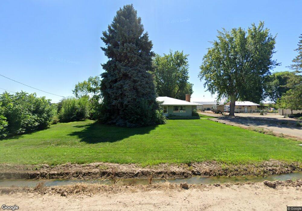
2175 E 1st St Fruitland, ID 83619
Estimated Value: $402,000 - $500,000
3
Beds
3
Baths
1,504
Sq Ft
$293/Sq Ft
Est. Value
About This Home
This home is located at 2175 E 1st St, Fruitland, ID 83619 and is currently estimated at $440,033, approximately $292 per square foot. 2175 E 1st St is a home located in Payette County with nearby schools including Fruitland Elementary School, Fruitland Preparatory Academy Alternative School, and Fruitland Middle School.
Ownership History
Date
Name
Owned For
Owner Type
Purchase Details
Closed on
Mar 7, 2025
Sold by
Ronald E Sullins Family Living Trust and Simkins Theresa L
Bought by
Apex Land Group Llc
Current Estimated Value
Purchase Details
Closed on
May 21, 2024
Sold by
Ronald E Sullins Family Living Trust and Simkins Theresa L
Bought by
Ronald E Sullins Family Living Trust and Simkins
Purchase Details
Closed on
Jun 28, 2023
Sold by
Ronald E Sullins Family Living Trust
Bought by
Simkins Tim L and Simkins Theresa L
Create a Home Valuation Report for This Property
The Home Valuation Report is an in-depth analysis detailing your home's value as well as a comparison with similar homes in the area
Home Values in the Area
Average Home Value in this Area
Purchase History
| Date | Buyer | Sale Price | Title Company |
|---|---|---|---|
| Apex Land Group Llc | -- | Title One | |
| Ronald E Sullins Family Living Trust | -- | None Listed On Document | |
| Simkins Tim L | -- | None Listed On Document | |
| Ronald E Sullins Family Living Trust | -- | None Listed On Document |
Source: Public Records
Tax History Compared to Growth
Tax History
| Year | Tax Paid | Tax Assessment Tax Assessment Total Assessment is a certain percentage of the fair market value that is determined by local assessors to be the total taxable value of land and additions on the property. | Land | Improvement |
|---|---|---|---|---|
| 2025 | $967 | $357,239 | $184,500 | $172,739 |
| 2024 | $967 | $420,709 | $225,659 | $195,050 |
| 2023 | $908 | $445,845 | $219,639 | $226,206 |
| 2022 | $1,289 | $444,444 | $218,238 | $226,206 |
| 2021 | $1,128 | $335,990 | $131,422 | $204,568 |
| 2020 | $748 | $210,439 | $61,291 | $149,148 |
| 2017 | $896 | $0 | $0 | $0 |
| 2016 | $886 | $0 | $0 | $0 |
| 2015 | $820 | $127,064 | $56,064 | $71,000 |
| 2014 | $795 | $118,750 | $46,870 | $71,880 |
Source: Public Records
Map
Nearby Homes
- 2150 E 1st St
- Shoshone Plan at Aspen Meadows
- 343 Blacksmith Ave
- 305 Bobcat
- 426 Stagecoach Ave
- 411 S Pennsylvania Ave
- 2833 Birch Rd
- 725 Lilac St
- 507 S Pennsylvania Ave
- 204 Crimson Cir E
- 413 S Minnesota Ave
- 135 Magnolia Ave
- 403 Blacksmith Ave
- 113 NW 4th St
- 418 S Iowa Ave
- 359 Lodgepole Ct
- TBD S Iowa Ave
- 351 Lodgepole Ct
- 1040 N Pennsylvania Ave
- 862 Brookwood Dr