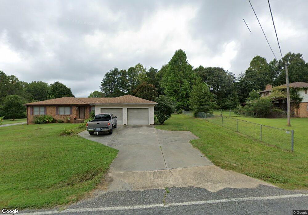
2176 Devine Rd Iron Station, NC 28080
Estimated Value: $260,000 - $337,000
3
Beds
2
Baths
1,442
Sq Ft
$200/Sq Ft
Est. Value
About This Home
This home is located at 2176 Devine Rd, Iron Station, NC 28080 and is currently estimated at $288,030, approximately $199 per square foot. 2176 Devine Rd is a home located in Lincoln County with nearby schools including Iron Station Elementary School, East Lincoln Middle School, and East Lincoln High School.
Ownership History
Date
Name
Owned For
Owner Type
Purchase Details
Closed on
May 7, 1999
Bought by
Cole James Robert and Cole Maledia S
Current Estimated Value
Purchase Details
Closed on
Jan 21, 1992
Bought by
Shank Jerome Steven and Shank Michele S
Create a Home Valuation Report for This Property
The Home Valuation Report is an in-depth analysis detailing your home's value as well as a comparison with similar homes in the area
Home Values in the Area
Average Home Value in this Area
Purchase History
| Date | Buyer | Sale Price | Title Company |
|---|---|---|---|
| Cole James Robert | $70,000 | -- | |
| Shank Jerome Steven | $62,000 | -- |
Source: Public Records
Tax History Compared to Growth
Tax History
| Year | Tax Paid | Tax Assessment Tax Assessment Total Assessment is a certain percentage of the fair market value that is determined by local assessors to be the total taxable value of land and additions on the property. | Land | Improvement |
|---|---|---|---|---|
| 2025 | $867 | $257,646 | $36,288 | $221,358 |
| 2024 | $857 | $257,646 | $36,288 | $221,358 |
| 2023 | $1,675 | $257,646 | $36,288 | $221,358 |
| 2022 | $1,111 | $135,428 | $26,000 | $109,428 |
| 2021 | $1,111 | $135,428 | $26,000 | $109,428 |
| 2020 | $969 | $135,428 | $26,000 | $109,428 |
| 2019 | $969 | $135,428 | $26,000 | $109,428 |
| 2018 | $1,050 | $130,458 | $25,000 | $105,458 |
| 2017 | $949 | $130,458 | $25,000 | $105,458 |
| 2016 | $949 | $130,458 | $25,000 | $105,458 |
| 2015 | $1,016 | $130,458 | $25,000 | $105,458 |
| 2014 | $1,010 | $130,958 | $25,500 | $105,458 |
Source: Public Records
Map
Nearby Homes
- 5486 E Highway 27
- 3388 Rhyne Forest Rd
- 1987 & 1981 Magnolia Grove Rd
- 1554 Forum Ln
- 1481 Depot St
- 3960 Orchard Rd
- 3132 Fox Den Cir
- 1279 Craig Dr
- 2651 Keever Dairy Farm Rd
- 00 Southmont Rd
- 1371 Alexis High Shoals Rd
- 222 Oakhill St
- 4394 Mountain Creek Rd
- 6 Hager Mountain Ln
- 1341 Mirror Lake Rd
- 4859 Paysour Pond Rd
- 00 Timber Rd
- 189 Fea Ln
- 375 Timber Rd
- 1585 Salem Church Rd
- 2160 Devine Rd
- 2184 Devine Rd
- 5099 Antebellum Dr
- 5095 Antebellum Dr
- 5091 Antebellum Dr
- 5087 Antebellum Dr
- 5063 Antebellum Dr
- 5071 Antebellum Dr
- 5067 Antebellum Dr
- 806 Latrobe Dr
- 838 Latrobe Dr
- 5035 Antebellum Dr
- 5024 Antebellum Dr
- 846 Latrobe Dr
- 5076 Antebellum Dr
- 5015 Antebellum Dr
- 863 Latrobe Dr
- 867 Latrobe Dr
- 847 Latrobe Dr
- 5068 Antebellum Dr