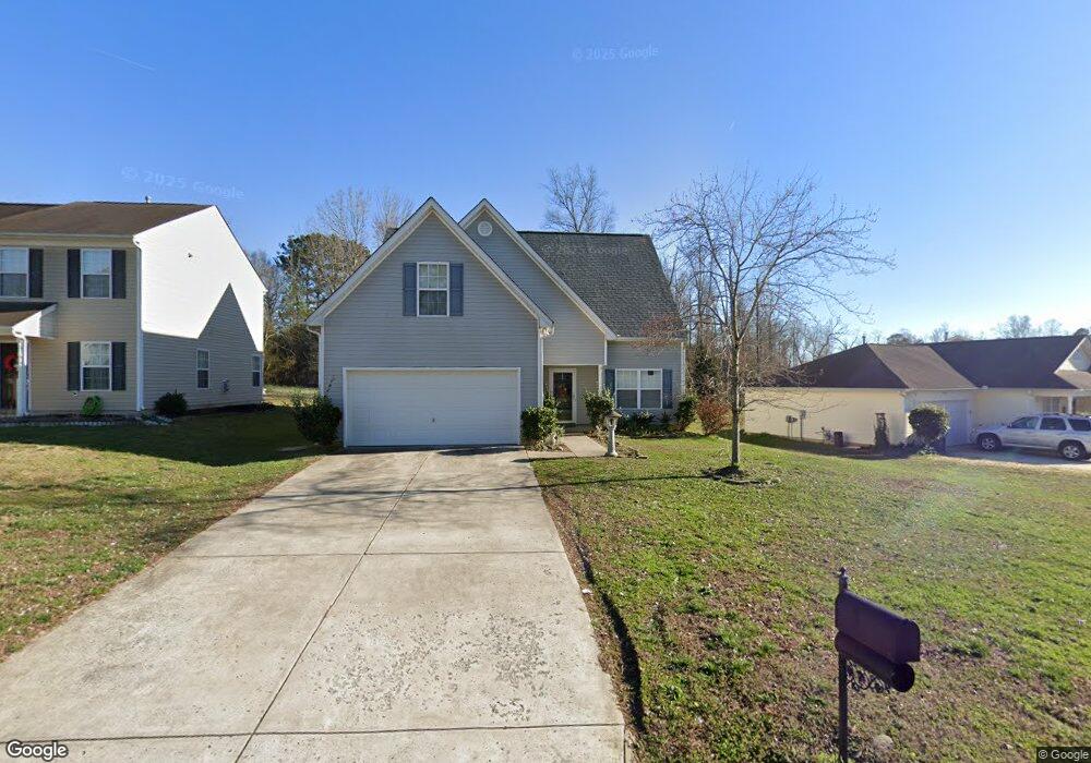
2176 Mallard Pointe Dr Kannapolis, NC 28083
Estimated Value: $301,000 - $348,000
3
Beds
3
Baths
1,628
Sq Ft
$195/Sq Ft
Est. Value
About This Home
This home is located at 2176 Mallard Pointe Dr, Kannapolis, NC 28083 and is currently estimated at $317,672, approximately $195 per square foot. 2176 Mallard Pointe Dr is a home located in Cabarrus County with nearby schools including Forest Park Elementary School, Kannapolis Middle, and A.L. Brown High School.
Ownership History
Date
Name
Owned For
Owner Type
Purchase Details
Closed on
May 25, 2007
Sold by
Deutsche Bank National Trust Co
Bought by
Hill Smith Sophia L and Smith Ashley O
Current Estimated Value
Home Financials for this Owner
Home Financials are based on the most recent Mortgage that was taken out on this home.
Original Mortgage
$141,900
Outstanding Balance
$86,078
Interest Rate
6.12%
Mortgage Type
Purchase Money Mortgage
Estimated Equity
$231,594
Purchase Details
Closed on
Feb 26, 2007
Sold by
Cochran William Melvin
Bought by
Deutsche Bank National Trust Co
Purchase Details
Closed on
Dec 19, 2003
Sold by
Craft Homes Usa Llc
Bought by
Cochran William Melvin
Home Financials for this Owner
Home Financials are based on the most recent Mortgage that was taken out on this home.
Original Mortgage
$120,692
Interest Rate
8.12%
Mortgage Type
Purchase Money Mortgage
Create a Home Valuation Report for This Property
The Home Valuation Report is an in-depth analysis detailing your home's value as well as a comparison with similar homes in the area
Home Values in the Area
Average Home Value in this Area
Purchase History
| Date | Buyer | Sale Price | Title Company |
|---|---|---|---|
| Hill Smith Sophia L | $142,000 | None Available | |
| Deutsche Bank National Trust Co | $132,974 | None Available | |
| Cochran William Melvin | $127,500 | -- |
Source: Public Records
Mortgage History
| Date | Status | Borrower | Loan Amount |
|---|---|---|---|
| Open | Hill Smith Sophia L | $141,900 | |
| Previous Owner | Cochran William Melvin | $120,692 |
Source: Public Records
Tax History
| Year | Tax Paid | Tax Assessment Tax Assessment Total Assessment is a certain percentage of the fair market value that is determined by local assessors to be the total taxable value of land and additions on the property. | Land | Improvement |
|---|---|---|---|---|
| 2025 | $3,346 | $294,630 | $69,000 | $225,630 |
| 2024 | $3,346 | $294,630 | $69,000 | $225,630 |
| 2023 | $2,274 | $165,960 | $41,000 | $124,960 |
| 2022 | $2,274 | $165,960 | $41,000 | $124,960 |
| 2021 | $2,274 | $165,960 | $41,000 | $124,960 |
| 2020 | $2,274 | $165,960 | $41,000 | $124,960 |
| 2019 | $1,655 | $120,810 | $17,000 | $103,810 |
| 2018 | $1,631 | $120,810 | $17,000 | $103,810 |
| 2017 | $1,607 | $120,810 | $17,000 | $103,810 |
| 2016 | $1,607 | $122,660 | $25,000 | $97,660 |
| 2015 | $1,546 | $122,660 | $25,000 | $97,660 |
| 2014 | $1,546 | $122,660 | $25,000 | $97,660 |
Source: Public Records
Map
Nearby Homes
- 2124 Clear Brook Dr
- 2020 Quill Ct
- 2495 Centergrove Rd
- 1838 Summit Ridge Ln
- 2564 Captains Watch Rd NE
- 304 Athens Hills Place
- 1713 Prism Place
- 915 Harbour View Cove NE
- 00 Dixie Dr
- 2208 Brantley Rd
- 361 China Grove Rd
- 108 S Little Texas Rd
- 1517 Jamaica Rd
- 141 Beaumont Ave
- 137 Beaumont Ave
- 2640 Centergrove Rd
- 1699 Mission Oaks St
- 2041 Brantley Creek Dr
- 2122 Centergrove Rd
- 1526 Shepard St
- 2180 Mallard Pointe Dr
- 2172 Mallard Pointe Dr
- 2184 Mallard Pointe Dr
- 2168 Mallard Pointe Dr
- 2188 Mallard Pointe Dr
- 2164 Mallard Pointe Dr
- 2171 Mallard Pointe Dr
- 2175 Mallard Pointe Dr
- 2167 Mallard Pointe Dr
- 2179 Mallard Pointe Dr
- 2163 Mallard Pointe Dr
- 2159 Mallard Pointe Dr
- 2160 Mallard Pointe Dr
- 2155 Mallard Pointe Dr
- 2192 Mallard Pointe Dr
- 2183 Mallard Pointe Dr
- 2151 Mallard Pointe Dr
- 2187 Mallard Pointe Dr
- 2147 Mallard Pointe Dr
- 2156 Mallard Pointe Dr
Your Personal Tour Guide
Ask me questions while you tour the home.