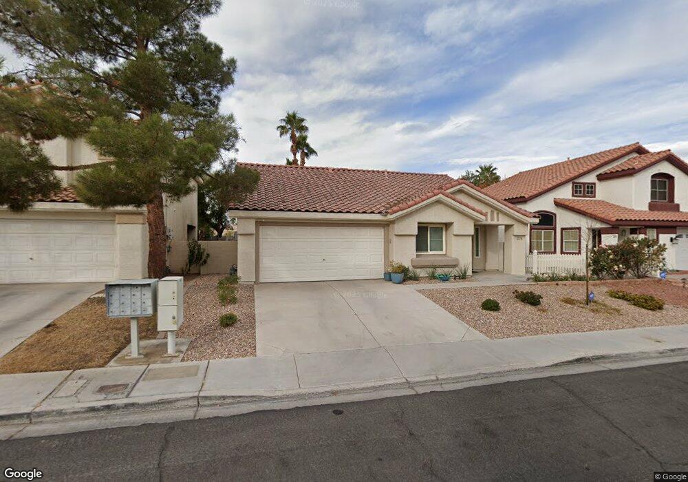
2178 Eaglecloud Dr Henderson, NV 89074
Green Valley South NeighborhoodEstimated Value: $406,000 - $418,000
3
Beds
2
Baths
1,407
Sq Ft
$294/Sq Ft
Est. Value
About This Home
This home is located at 2178 Eaglecloud Dr, Henderson, NV 89074 and is currently estimated at $413,646, approximately $293 per square foot. 2178 Eaglecloud Dr is a home located in Clark County with nearby schools including Selma F Bartlett Elementary School, Barbara and Hank Greenspun Junior High School, and Coronado High School.
Ownership History
Date
Name
Owned For
Owner Type
Purchase Details
Closed on
Dec 30, 2014
Sold by
Armbrister Marna S
Bought by
Armbrister Marna S
Current Estimated Value
Purchase Details
Closed on
Apr 28, 2007
Sold by
Shepard Leon and Shepard Mary
Bought by
Shepard Leon and Armbrister Marna
Purchase Details
Closed on
Feb 8, 2002
Sold by
Shepard Mary and Shepard Leon
Bought by
Shepard Mary and Shepard Leon
Purchase Details
Closed on
Apr 20, 1994
Sold by
Beazer Homes Nevada Inc
Bought by
Shepard Leon and Shepard Mary
Home Financials for this Owner
Home Financials are based on the most recent Mortgage that was taken out on this home.
Original Mortgage
$87,200
Interest Rate
7.79%
Create a Home Valuation Report for This Property
The Home Valuation Report is an in-depth analysis detailing your home's value as well as a comparison with similar homes in the area
Home Values in the Area
Average Home Value in this Area
Purchase History
| Date | Buyer | Sale Price | Title Company |
|---|---|---|---|
| Armbrister Marna S | -- | None Available | |
| Shepard Leon | -- | None Available | |
| Shepard Mary | -- | -- | |
| Shepard Leon | $109,000 | First American Title Company |
Source: Public Records
Mortgage History
| Date | Status | Borrower | Loan Amount |
|---|---|---|---|
| Previous Owner | Shepard Leon | $87,200 |
Source: Public Records
Tax History
| Year | Tax Paid | Tax Assessment Tax Assessment Total Assessment is a certain percentage of the fair market value that is determined by local assessors to be the total taxable value of land and additions on the property. | Land | Improvement |
|---|---|---|---|---|
| 2026 | $1,772 | $90,148 | $38,500 | $51,648 |
| 2025 | $1,721 | $89,472 | $36,750 | $52,722 |
| 2024 | $1,671 | $89,472 | $36,750 | $52,722 |
| 2023 | $1,671 | $88,582 | $38,150 | $50,432 |
| 2022 | $1,622 | $75,345 | $29,190 | $46,155 |
| 2021 | $1,575 | $71,416 | $27,300 | $44,116 |
| 2020 | $1,526 | $69,351 | $25,550 | $43,801 |
| 2019 | $1,482 | $66,165 | $22,750 | $43,415 |
| 2018 | $1,439 | $60,858 | $18,900 | $41,958 |
| 2017 | $1,764 | $60,585 | $18,200 | $42,385 |
| 2016 | $1,363 | $57,080 | $14,350 | $42,730 |
| 2015 | $1,360 | $45,255 | $10,150 | $35,105 |
| 2014 | $1,320 | $45,614 | $8,750 | $36,864 |
Source: Public Records
Map
Nearby Homes
- 78 Fortuna Ct
- 2132 Polynesia Cir
- 2176 Mccartney Ct
- 2201 Ramsgate Dr Unit 923
- 2201 Ramsgate Dr Unit 622
- 2201 Ramsgate Dr Unit 326
- 2201 Ramsgate Dr Unit 818
- 2201 Ramsgate Dr Unit 911
- 2201 Ramsgate Dr Unit 514
- 2107 Eaglepath Cir
- 73 Sea Holly Way
- 2251 Wigwam Pkwy Unit 225
- 2251 Wigwam Pkwy Unit 1822
- 2251 Wigwam Pkwy Unit 211
- 2251 Wigwam Pkwy Unit 1927
- 2251 Wigwam Pkwy Unit 921
- 2251 Wigwam Pkwy Unit 422
- 2251 Wigwam Pkwy Unit 526
- 2251 Wigwam Pkwy Unit 1324
- 2251 Wigwam Pkwy Unit 218
- 2180 Eaglecloud Dr
- 2176 Eaglecloud Dr
- 79 Motu Ct
- 2182 Eaglecloud Dr
- 77 Motu Ct
- 2190 Polynesia Cir
- 2174 Eaglecloud Dr
- 2179 Eaglecloud Dr
- 2177 Eaglecloud Dr
- 2188 Polynesia Cir
- 75 Motu Ct
- 2175 Eaglecloud Dr
- 2181 Eaglecloud Dr
- 2184 Eaglecloud Dr
- 2186 Polynesia Cir
- 2194 Polynesia Cir
- 2183 Eaglecloud Dr
- 2173 Eaglecloud Dr
- 2184 Polynesia Cir
- 81 Huntfield Dr
Your Personal Tour Guide
Ask me questions while you tour the home.